USGS Open-File Report 03-474, G1-03-GM, Gas Hydrates Cruise Report, R/V Gyre, 1-14 May 2003, Northern Gulf of Mexico
Title Page
Abstract
INTRODUCTION
Acknowledgments
Geologic Settings
Cruise Objectives
Cruise Strategy
Instrumentation
Data Processing
Data Handling
Marine Mammal Mitigation
Operational Summary
Success in Meeting Objectives
Summary
References
Appendices
1. Multichannel
Line Statistics
2. Summary of
Digital Data
3. Marine
Mammal
Documents
4. Science
Roster
5. Ship Roster &
Specifications
6. Photo Gallery
Introduction
Gas Hydrates in the Gulf of Mexico
Gas hydrates are well known for their capacity to change the physical properties of near surface sediments and might be linked to massive slope failures on continental margins (Paull and others, 2000). As drilling in the Gulf of Mexico has progressed from shallow-water shelf depths (< 200 m) to deep-water slope depths (> 1,000 m), wells now penetrate the gas hydrate stability zone. Because drilling can change the physical conditions around the drill hole (for example, by allowing warm fluids from depth to circulate shallow in the hole), potentially causing hydrate to dissociate (i.e., melt), many researchers and engineers anticipate that drilling through hydrate may pose a hazard to the stability of the well, the platform anchors, tethers, or even entire platforms (Hovland and Gudmestad, 2001). In order to understand these consequences to drilling, it is imperative to understand the physical and chemical conditions and the geological environment in which these hydrates exist and to be able to estimate the distribution and concentration of gas hydrate deposits. In May 2003, USGS conducted a 14-day cruise aboard R/V Gyre to collect high-resolution seismic reflection data and develop the geologic framework around two potential deep-water sites anticipated to be drilled in the spring of 2004, to study gas hydrates in the Gulf of Mexico.
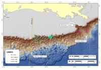 |
| Figure 1. Click on figure for larger image with caption. |
The Gyre cruise (USGS cruise ID: G1-03-GM) is one part of a much larger program of hydrate research in the Gulf of Mexico. Specifically, the cruise is coordinated with a Joint Industry Program (JIP) funded by the Department of Energy (DOE) to assess the hazard that hydrates pose to deep-water drilling. The two primary study areas for the cruise (Fig. 1), lease blocks Keathley Canyon 195 and Atwater Valley 14, were selected from six sites that the JIP originally considered for drilling. Additional site-survey work done in August, 2003, using near-bottom instrumentation (the Deep-Towed Acoustic/Geophysical System (DTAGS) multichannel seismic instrument from the Naval Research Lab, heat flow measurements from Georgia Tech, and electrical resistivity measurements from the Woods Hole Oceanographic Institution) utilized preliminary interpretations from the Gyre cruise. Selected lines from the USGS Gyre cruise will be re-occupied by these specialized instruments to further characterize the geology and hydrate character of the potential drill sites. This work also builds on a strong foundation of hydrate research in the Gulf that has been built by numerous academic research groups (see Sassen and others, 2001, and Roberts, 2001, and references therein).
This cruise report gives an operational summary of the Gyre 2003 cruise. The information covered includes descriptions of the instrumentation, on-board operations, tabulated statistics, and textual and map summaries of the data. Examples of the data collected are given in short summaries of each site survey. Scientific results and interpretations will be presented elsewhere.
