
 |
Introduction
INTRODUCTION
The purpose of this publication is to make available detailed trench logs (sheets 1 through 8), radiocarbon dates (table 1) and brief stratigraphic unit descriptions (Appendix 1) obtained as a result of an intensive subsurface investigation of the Hayward Fault at Tyson's Lagoon (Tule Pond) from 2001 through 2003 (figs. 1, 2 and 3 on sheet 2). Preliminary findings of this investigation based on fieldwork done in 2000 have been published as Lienkaemper and others (data archive, 2002a; report, 2002b). The Hayward Fault is recognized to be among the most hazardous in the United States (Working Group on California Earthquake Probabilities, 1999). This document makes available geologic evidence for historical and prehistoric surface-rupturing earthquakes preserved at the site. Establishing a chronology of prehistoric or paleoearthquakes is of immediate use in resolving the level of hazard posed by the Hayward Fault for producing large earthquakes in the future. A second formal report on our conclusions based on these data is in preparation. The investigation at Tyson's Lagoon is ongoing, so these products should not be considered final. Lienkaemper, Williams, Dawson and Personius interpreted the geology and logged the trenches. Seitz and Heller performed analyses on the radiocarbon samples. Schwartz led the critical-review field team
Previous trenching work was done at Tyson's Lagoon (figs. 2, 3 on sheet 2). Lienkaemper (1992) references the location of most of those trenches. The earlier trenching was generally for the evaluation of local fault-rupture hazard, except for the study of Williams (1993), which was a paleoearthquake investigation. An unpublished study by J.N. Alt in 1998 (shown on our site map as trenches 98A and 98B, fig. 3, on sheet 1), also sought evidence of paleoearthquakes. Alt's study and one by Woodward-Clyde and Associates (1970; trenches 70A to 70G, fig. 3) were located south of Walnut Avenue in one of the few areas that still remain undisturbed and were, thus, useful in planning our work in 2000. Unpublished field investigations at this site by P. L. Williams in 1992 have been incorporated in this report. His trench W2 is presented herein as sheet 8 (see fig. 3 sheet 2 for location). William's 1992 trench W1 was re-excavated by us in 2002 and is shown as trench 02E (sheet 4).
Version 2.0 corrects stratigraphic correlations across the pond based on continuous trenching across the entire pond in 2005 (Lienkaemper and others, 2005). Logs of trenches within the pond and across the eastern fault trace have been corrected (sheets 1, 3, 4, 6, 7 and 8.) Logs of trenches O2A (sheet 2) and 03A (sheet 5) required no revision in unit correlation.
Version 3.0 delineates two paleoearthquake horizons between unit u100 and u80. Formerly only one horizon had been shown on most logs. Hence, all paleoearthquake event horizons have been renumbered below unit u100 to reflect this correction to the earthquake sequence.
|
| File Name |
Size |
Size (in.) |
Description |
120 KB |
|
Pamphlet (5 pages) | |
| 5.8 MB |
21.75 x 26.75 |
Sheet 1 - Logs of Trench 01A | |
| 5.9 MB | 31.50 x 34.00 |
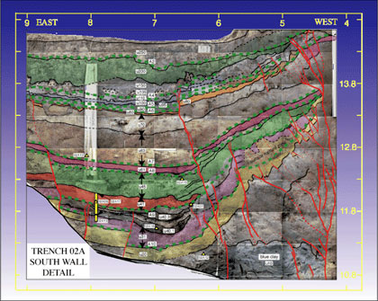
Sheet 2 - Logs of Trench 02A and location & site maps | |
| 0.7 MB | 14.40 x 14.00 |
Sheet 3 - Logs of Pits 02B, C, D | |
| 8.1 MB | 27.10 x 34.20 | Sheet 4 - Logs of Trench 02E | |
| 4.8 MB |
25.50 x 30.20 |
Sheet 5 - Logs of Trench 03A | |
| OF03_488s6.3.pdf | 3.5 MB | 21.40 x 24.50 | Sheet 6 - Logs of Trench 3B (W1) |
| OF03_488s7.3.pdf | 4.4 MB | 12.50 x 40.75 | Sheet 7 - Cross section (03A, B, C, D, E) |
| 1.4 MB | 17.00 x 40.50 |
Sheet 8 - Logs of Trench W2 (1992) |
|
| contents.txt | 8 kb | description of report and files | |
| version_history.txt | 56 kb | description of changes |
For questions about the content of this report, contact Jim Lienkaemper
Download a current version of Acrobat Reader for free
| Help
| PDF help
| Geopubs main page | Open-File
Reports for 2003 |
| Privacy
Statement | Disclaimer
| Accessibility |
| Geologic Division |
Earthquake Hazards Program |
This report is available only on the Web