Map and Data for Quaternary Faults and Folds in Oregon |
By Stephen F. Personius, Richard L. Dart, Lee-Ann Bradley and Kathleen M. Haller |
| U.S. Geological Survey Open-File Report 03-095 |
| Version 1.1 |
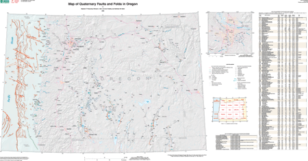
| The map shows faults and folds in the state of Oregon that exhibit evidence of Quaternary deformation, and includes data on timing of most recent movement, sense of movement, slip rate, and continuity of surface expression. The primary purpose of this compilation is for use in earthquake-hazard evaluations. Paleoseismic studies, which evaluate the history of surface faulting or deformation along structures with evidence of Quaternary movement, provide a long-term perspective that augments the short historic records of seismicity in many regions. Published or publicly available data are the primary sources of data used to compile this report. |
| The text of this report is presented here in Portable Document Format. The latest version of Adobe Acrobat Reader or similar software is required to view it. If you wish to download the latest version of Acrobat Reader free of charge, click here . |
| Metadata HTML file |
|
|
For viewing and printing. This is a large file to view through your browser. Our recommendation is to download to a local disk. For instructions on how to download click here. |
| Data PDF file
(1.14 MB) |
Data to accompany map. (A version of the this report that is accessible as defined in Section 508 is forthcoming.) |
| Text-Only PDF file (781 KB) | Text version of map. (This version of the report is accessible as defined in Section 508.) |
| AccessibilityFOIAPrivacyPolicies and Notices | |
| |
|