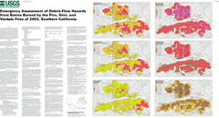
These maps present preliminary assessments of the probability of debris-flow
activity and estimates of peak discharges that can potentially be generated
by debris flows issuing from basins burned by the Piru, Simi and Verdale
Fires of October 2003 in southern California in response to the 25-year,
10-year, and 2-year 1-hour rain storms. The probability maps are based
on the application of a logistic multiple regression model that describes
the percent chance of debris-flow production from an individual basin
as a function of burned extent, soil properties, basin gradients and
storm rainfall. The peak discharge maps are based on application of a
multiple-regression model that can be used to estimate debris-flow peak
discharge at a basin outlet as a function of basin gradient, burn extent,
and storm rainfall.
|
|
Part or all of this report is presented in Portable Document Format. The latest
version of Adobe Acrobat Reader or similar software is required
to view it. If you wish to download the latest version of Acrobat
Reader free of charge, click here.
|
|
