
Coastal and Marine Geology Program / USGS Woods Hole Science Center
Click for Printable Version in PDF format
Content Metadata Standards for Marine Science: A Case Study
USGS Open-File Report 2004-1002
by Rebecca L. Riall, Fausto Marincioni, and Frances L. Lightsom
TITLE PAGE
Introduction
Cataloguing
Challenges
Evolution
MRIB Case Study
Discussion/
Challenges
Conclusion
References
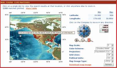
Figure 5. Map view and named locations are two ways the MRIB
interface provides the spatial context of information
resources. Click on figure for larger image.
Abstract
The U.S. Geological Survey developed a content metadata standard to meet the demands of organizing electronic resources in the marine sciences for a broad, heterogeneous audience. These metadata standards are used by the Marine Realms Information Bank project, a Web-based public distributed library of marine science from academic institutions and government agencies. The development and deployment of this metadata standard serve as a model, complete with lessons about mistakes, for the creation of similarly specialized metadata standards for digital libraries.
![]() To view files in PDF format, download free copy of Adobe Acrobat Reader.
To view files in PDF format, download free copy of Adobe Acrobat Reader.
"Any use of trade names is for descriptive purposes only and does not imply endorsement by the U.S. Government."
