|
|
|
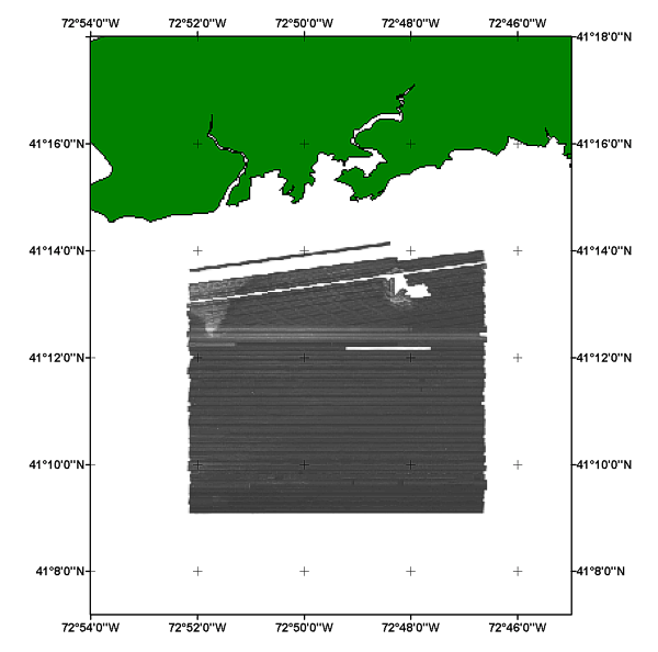
H11043_GEO_WGS84.TIF - Composite digital sidescan sonar mosaic of NOAA survey H11043 off Branford, Connecticut |
Metadata also available as: FAQ | TEXT
Anthropogenic wastes, toxic chemicals, and changes in land-use patterns resulting from residential, commercial, and recreational development have stressed the environment of the Sound, causing degradation and potential loss of benthic habitats (Koppelman and others, 1976; Long Island Sound Study, 1994). Detailed maps of the sea floor are needed to help evaluate the extent of adverse impacts and to help manage resources wisely in the future. Therefore, in a continuing effort to better understand Long Island Sound, we have constructed and interpreted sidescan sonar mosaics (complete-coverage acoustic images of the sea floor) within specific areas of special interest (Poppe and Polloni, 1998; fig. 1). The mosaic presented herein covers a 41.1 km2 of the sea floor in north-central Long Island Sound off Branford, Connecticut.
The mosaics and their interpretations serve many purposes, including: (1) defining the geological variability of the sea floor, which is one of the primary controls of benthic habitat diversity; (2) improving our understanding of the processes that control the distribution and transport of bottom sediments and the distribution of benthic habitats and associated infaunal community structures; and (3) providing a detailed framework for future research, monitoring, and management activities. The sidescan sonar mosaics also serve as base maps for subsequent sedimentological, geochemical, and biological observations, because precise information on environmental setting is important for selection of sampling sites and for accurate interpretation of point measurements.
The sidescan sonar data were multiplexed and filtered to convert the data into the desired processing format and to remove speckle noise and corrected for slant-range distortions. and imported into SonarWeb, an application that creates mosaics from raw XTF sidescan sonar data. The mosaic include the following standards: 1 meter resolution, image 'shine through', and auto contrast adjustment (with a 12.9% contrast increase).
The image includes a white background (no data) surrounding the sidescan sonar image. High dn values represent low backscatter and low dn values represent high backscatter.