|
|
| Coastal and Marine Geology Program | Woods Hole Science Center |
U.S. Geological Survey Open-File Report 2004-1003
|
Data Acquisition and Processing |
DATA ACQUISITION AND PROCESSING
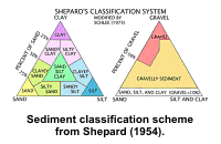
The sidescan sonar data were multiplexed and filtered to convert the data into the desired processing format and to remove speckle noise and to correct for slant-range distortions. The data were imported into SonarWeb, an application that creates mosaics from raw XTF sidescan sonar data. The mosaic includes the following standards: 1 meter resolution, image 'shine through', and auto-contrast adjustment (with a 12.9% contrast increase). This mosaic was reprojected into geographic coordinates. To further facilitate interpretation, a contrast enhancement based on the dynamic range of the data was applied to the composite image to produce the final enhanced image. Interested readers can access more information regarding sidescan sonar acquisition and processing at the USGS Woods Hole Science Center's Sea-Floor Mapping Technology website. Lighter tones in the sidescan sonar imagery suggest relatively harder acoustic returns, coarser sediments and higher energy environments. Darker tones in the sidescan sonar imagery suggest relatively softer acoustic returns, finer sediments, and lower energy environments. Two tonal artifacts, both caused by inaccurate across-track normalization, are present on the sidescan sonar imagery. One artifact. which appears as a darker than normal band, affects 6 sidescan sonar lines in the southernmost part of the imagery. The other artifact, which appears as a lighter than normal band, affects 4 sidescan sonar lines in the central part of the imagery. For verification, pre-existent bathymetric (DiGiacomo-Cohen and others, 1998), photographic, and surficial sediment data (Poppe and Polloni, 1998, Poppe and others, 2000a) were used to interpret the sidescan sonar imagery. The bathymetric contours were digitized from NOAA charts; vertical datum is mean lower low water. Most of the surficial sediment samples were collected with a modified Van Veen grab sampler. The photographic data were used to appraise intra-station bottom variability, faunal communities, and processes and to observe boulder fields where samples could not be collected. The sediment descriptions are based on the nomenclature proposed by
Wentworth (1922), The interpretations of sea-floor features, surficial sediment distributions, and sedimentary environments presented in this report are based on data from the sediment sampling and bottom photography stations, on tonal changes in backscatter on the sidescan sonar image, and on the bathymetry. |