
U.S. Geological Survey
Open-File Report 2004-1026
Version 1.0
2004
Online only
By Gilpin R. Robinson, Jr., Katherine E. Kapo, and Jeffrey N. Grossman
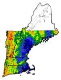

(above: New England stream sediment chemistry distributions for Fe2O3)
Table of Contents
1.0 Summary
2.0 Introduction
3.0 Source Data
4.0 Spatial Data Analysis
5.0 Geochemical Groups and Associations
6.0 Geochemical Dataset Figures
7.0 References
Other Links
Full Text Report (PDF)
635 KB
Printable Figures (PDF files)
Raw Data and Interpolation Grids
(database links and downloadable ASCII grid data files)
1.0 Summary
This online publication portrays regional data for pH, alkalinity, and specific conductance for stream waters and a multi-element geochemical dataset for stream sediments collected in the New England states of Connecticut, Maine, Massachusetts, New Hampshire, Rhode Island, and Vermont. A series of interpolation grid maps portray the chemistry of the stream waters and sediments in relation to bedrock geology, lithology, drainage basins, and urban areas. A series of box plots portray the statistical variation of the chemical data grouped by lithology and other features.
2.0 Introduction
The chemistry of sediments and waters at the surface of the earth influence important geochemical and life cycles. The geochemical variability of stream sediments and surface waters result from a complex interaction of a variety of geochemical sources and transport and deposition processes. Important factors for geochemical variability include:
1) Geochemical and mineralogical variation in the source rocks that are the main medium from which soils and sediments develop,
2) Variation in the physiography, erosion, and weathering of the source rocks and the related variation in the deposition and distribution of sediments in drainage basins whose interaction with waters influence water chemistry and sediment mineralogy, and
3) Variation in land use and human-related influences on sediment and water chemistry.
The objective of this work is to concisely describe the geochemical characteristics and portray the spatial distribution and variation of 8 major and 17 minor elements in stream sediments and 3 chemical features of surface waters in relation to geologic units, rock type groups, and population density features whose aerial extent is large enough to be illustrated on a map of New England at a scale of 1:500,000. This portrayal facilitates the comparison of the chemistry in relation to geologic, drainage basin, and other factors and identifies areas of relative enrichment or deficiency due to both geologic and human-related phenomena.
2.1 Background
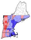
From 1977 to 1980, the Hydrogeochemical and Stream Sediment Reconnaissance (HSSR) component of the National Uranium Resource Evaluation (NURE) Program conducted by the Department of Energy collected stream sediments and waters at 8360 sample sites in the New England states of Connecticut, Maine, Massachusetts, New Hampshire, Rhode Island, and Vermont. Field measurements for pH, alkalinity, and specific conductance were determined for 7119 sample sites in New England (Figure 1). 7905 stream sediment samples were processed and received at least partial chemical analysis. Information on the NURE samples is given in Smith (2001-a) and the data was released in Grossman (1998) and Smith (2001-b). In 1999, a randomly distributed subset of 1597 stream sediment samples were selected for reanalysis by more modern analytical methods from an archive of the NURE stream sediment samples (Figure 2).
Direct questions and comments to:
Gilpin R. Robinson
U.S. Geological Survey
Email grobinso@usgs.gov
Phone (703)-648-6113