Skip past header information USGS Logo with link to USGS web page
Coastal Vulnerability Assessment of Cape Hatteras National Seashore to Sea-Level Rise, USGS Open-File Report 2004-1064


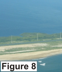
Figure 8. Oblique view of the narrow part of the island shown in Figure 7. The NC Department of Transportation has planted dune-colonizing grass, which shows up in a gridded pattern (very high vulnerability).


Figure 8. The NC Department of Transportation has planted dune-colonizing grass, which shows up in a gridded pattern (very high vulnerability. Figure 8. The NC Department of Transportation has planted dune-colonizing grass, which shows up in a gridded pattern (very high vulnerability. Figure 8. The NC Department of Transportation has planted dune-colonizing grass, which shows up in a gridded pattern (very high vulnerability.

Skip Footer Information

U.S. Department of the Interior, U.S. Geological Survey
URL: http://pubs.usgs.gov/of/2004/1064/html/fig8.html
Maintained by Publishing Services
Last modified: 09:14:08 Thu 20 May 2004
Privacy statement | General disclaimer | Accessibility