![[Link to USGS home page]](images/wrcmgbnr.gif)
![]()
![]()
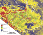
| Predicted Seafloor Facies of Central Santa Monica Bay, California |
Predicted Seafloor Facies and Multibeam Data
|
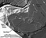
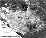
This Open-File Report contains the seafloor facies predicted using multibeam bathymetry and acoustic backscatter as well as ground-truth information from Short Bank, central Santa Monica Bay, CA. The report also contains the multibeam bathymetry and acoustic backscatter data used in the study.
The seafloor facies are available as a georeferenced TIFF image (UTM projection), where as the multibeam bathymetry and backscatter data are available as XYZ (geographic) or ArcInfo GRID (UTM projection). Multibeam bathymetry and acoustic backscatter data collected by the U.S. Geological Survey of the Los Angeles Margin are available at, http://geopubs.wr.usgs.gov/open-file/of02-162/
Absolute Value(2DN/dB) where DN ranges from 0 to 255 and dB ranges from 0 to -127. Download Instuctions: XYZ Format 1. Download the file to the desktop. 2. Uncompress the file. The file is compressed with WinZip 7.0. 3. The uncompression will result in a new comma-delimited file (bathy.xyz, mos.xyz). ArcInfo GRID 1. Download the file to the desktop. 2. Uncompress and unbundle the file. Since ESRI GRIDs are directories of files, the directories have been bundled into a single file and then compressed for downloading. Windows - Double click on the file (*.tgz). Winzip 7.0 will uncompress the file resulting in a new bundled file (*.tar). Double click on the new file and Winzip 7.0 will unbundle the file into a new folder (bathy or mos). The ESRI GRID (bathyg or mosg) is contained within the folder. UNIX - Uncompress using "gunzip" then unbundle using "tar xf". Disclaimer: Downloading files can sometimes be problematic. Different web browsers and operating systems act differently. The instructions above may vary from system to system or may not work at all. One possible problem when downloading the file using Netscape, the *.tgz extension automatically changes to *.tar and the file does not uncompress correctly. If this is the case change the *.tar back to *.tgz and uncompress as normal. |
 |
![[Reports]](images/nav_rprt.gif) |
 |
![[Home]](images/nav_home.gif) |
|
![[Search]](images/nav_srch.gif) |
 |