Home Page
Mosaic & Explanation
GIS Data
Contacts
About this Disk
|
About this Disk
Directories and Files
Files
- index.htm
- This file the starting point for
this report.
- readme.txt
- ASCII text file containing a description of this report.
Directories:
- arcgis - ESRI ArcGIS ArcMap 8.3 map
file, ofr2004_1082.mxd and an ArcView 3.3 project file,
ofr2004_1082.apr.
- coastal_relief
- sun-illuminated TIFF image of the National Geophysical
Data Center (NGDC) Coastal Relief Model
- metadata
- metadata for all the files utilized within
the MXD and APR files
- mosaic-
sidescan-sonar mosaic files:
-farallones.tif/farallones.tfw -
full resolution TIFF
image (4 meter/pixel)
-farallones.sid/farallones.sdw -
LizardTech's MrSID Version
1.4 image compression software image file
- shape
- shapefiles called by MXD and APR
files, in subdirectories:
- html
- HTML pages of this report and subdirectories: with the
following subdirectories:
- images
- image files for HTML pages
- PDF -
PDF versions of figures
- ivs- contains a
3-D scene file viewable with Fledermaus or iView3D
and a 'fly-through' mpeg movie file
 Return to the top of page
System and Software Requirements
Operating Systems
This report can be accessed using the
Microsoft Windows, Macintosh and UNIX.
The ESRI
ArcMap map file, ofr2004_1082.mxd will run only
on Microsoft Windows systems, whereas the ArcView project file,
ofr2004_1082.apr, will run on both Microsoft Windows systems
and a UNIX platform.
ArcMap and Arcview
The arcgis directory contains two Environmental Systems Research
Institute (ESRI) files: an ArcMap 8.3 Geographic
Information Systems (GIS) map file, ofr2004_1082.mxd
and an ArcView 3.3 GIS project file, ofr2004_1082.apr. The
user must have a copy of ESRI ArcMap 8.3 and/or ArcView 3.3 in order
to view these documents. If the viewer does not have access to the
aforementioned software, individual data files can be viewed with
a free viewer such as ArcExplorer, or other viewer capable of
reading georeferenced images and shapefiles. All associated GIS files are also contained
within the ArcGIS directory. Visit the ESRI Website
(http://www.esri.com)
for information concerning ArcExplorer or other software.
3D Views
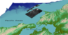 |
| Figure
7. Three-dimensional view of sidescan-sonar and coastal
relief data collected within the Gulf of the Farallones. Elevation
range: -3800 (dark blue) - +1450 (light brown) (PDF version, 1.3 mb). |
Interactive Visualization
Systems (IVS)
Fledermaus software package was used to view the sidescan-sonar and
coastal relief data in three dimensions. The Fledermaus scene
file was generated and is included in this report. This file can be
viewed using Fledermaus software or by downloading the IVS
free 3-D viewer, iView3D.
Return to the top of page
Disclaimer and Accessibility
Disclaimer
This CD-ROM publication was prepared by an agency of the
United States Government. Neither the United States Government nor
any agency thereof, nor any of their employees, make any warranty,
expressed or implied, or assumes any legal liability or responsibility
for the accuracy, completeness, or usefulness of any information,
apparatus, product, or process disclosed in this report, or represents
that its use would not infringe privately owned rights. Reference
therein to any specific commercial product, process, or service
by trade name, trademark, manufacturer, or otherwise does not necessarily
constitute or imply its endorsement, recommendation, or favoring
by the United States Government or any agency thereof. Any views
and opinions of authors expressed herein do not necessarily state
or reflect those of the United States Government or any agency thereof.
Although all data published on this CD-ROM have been used by the
USGS, no warranty, expressed or implied, is made by the USGS as
to the accuracy of the data and/or related materials. The act of
distribution shall not constitute any such warranty, and no responsibility
is assumed by the USGS in the use of these data or related materials.
Accessibility:
Section 508 and Accessibility at the USGS
The USGS is committed to and is making every possible effort
to ensure that all electronic and information technology developed, procured,
maintained, or used by the USGS is accessible to people with disabilities,
including both employees and the customers we serve. If you cannot fully
access the information on this DVD-ROM, please e-mail the contact person
or group named in the contact information provided on this DVD-ROM, and
they will help you. This may include providing the information to you
in an alternate format.
For further information and to learn more about the regulations
governing the accessibility of Federal electronic information products
visit the Section 508 web pages listed below:
Section 508 home page - http://www.section508.gov/
Access Board - http://www.access-board.gov/508.htm
Web Accessibility Initiative (WAI) - http://www.w3.org/WAI/
To view files in PDF format, download
free copy of Adobe Reader http://www.adobe.com/products/acrobat/alternate.html.
|
