Skip past header information USGS Logo with link to USGS Web page
Coastal Vulnerability Assessment of Cumberland Island National Seashore to
Sea-Level Rise, USGS Open-File Report 2004-1196


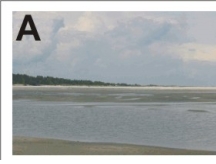
Figure 3A. Photo taken from Long Point looking towards Christmas Creek. The dunes are low and generally coppice mounds near Long Point.


Figure 3A. Photo from Long Point looking towards Christmas Creek, dunes are low and generally coppice near Long Point. Figure 3A. Photo from Long Point looking towards Christmas Creek, dunes are low and generally coppice near Long Point. Figure 3A. Photo from Long Point looking towards Christmas Creek, dunes are low and generally coppice near Long Point.

Skip Footer Information

U.S. Department of the Interior, U.S. Geological Survey
URL: http://pubs.usgs.gov/of/2004/1196/html/fig3a.html
Maintained by Publishing Services
Last modified: 16:02:27 Tue 15 Aug 2006
Privacy statement | General disclaimer | Accessibility