
U.S. Geological Survey
Open-File Report 2004-1235
Online only
Published 2004
Version 1.0
A high-resolution PDF version of the "Distribution of Holocene Sediment in Chesapeake Bay as Interpreted from Submarine Geomorphology of the Submerged Landforms, Selected Core Holes, Bridge Borings and Seismic Profiles" map is presented here [4.65 MB]. (Download Adobe Reader 6.0 for free).
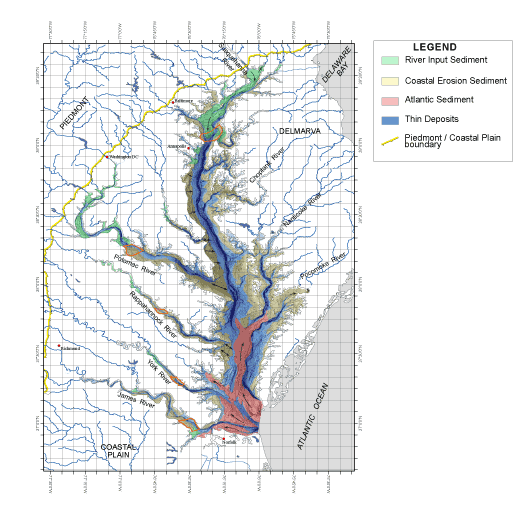 We have interpreted the geomorphology of the submerged landforms to show thick Holocene sediment that
accumulated from three different sources during on-going sea level rise that began 10,000 - 12,000
years ago at the end of Pleistocene. We used a variety of subsurface data from the literature and unpublished
information to document thicknesses, materials, dates and duration of processes. Although the details of the
true extent and thicknesses are unknown, the deposits of different sources have affinity for particular geographic
and submerged geomorphic regions of the Chesapeake Bay and its tidal tributaries.
We have interpreted the geomorphology of the submerged landforms to show thick Holocene sediment that
accumulated from three different sources during on-going sea level rise that began 10,000 - 12,000
years ago at the end of Pleistocene. We used a variety of subsurface data from the literature and unpublished
information to document thicknesses, materials, dates and duration of processes. Although the details of the
true extent and thicknesses are unknown, the deposits of different sources have affinity for particular geographic
and submerged geomorphic regions of the Chesapeake Bay and its tidal tributaries.
During the last Pleistocene glacial event (Wisconsian), the area now occupied by the Chesapeake Bay was exposed, sea level being about 100 m lower than present. The Susquehanna River valley extended beyond the Bay well out on the exposed Atlantic Shelf. The Susquehanna transported glacial outwash from northern Pennsylvania and New York; the glacio-fluvial deposits were graded to the edge of the continental shelf (Colman et al., 1990; Hack, 1957). Other Piedmont and Appalachian Rivers including the Potomac and James Rivers transported large volumes of sediment to confluence with the Susquehanna channel. Locally, across the encompasing coastal plain landscape, intensive headward erosion, gullies, and slope failure, generated extensive debris flows, sheet wash, and terraces of braided alluvial channel deposits. Large volumes of sediment were moved through the river system to the continental shelf. This was accomplished by a cold, wet climate that included much freezing and thawing; steep eroding slopes resulted from the lowering of sea level from the previous high stand (Stage 5e) between glacial events. Across the Delmarva peninsula extensive wind-blown deposits of sand and loess were recycled onto low terraces and uplands from the unvegetated glacio-fluvial sediments moving through the system (Denny et al., 1979). The volume and distribution of sediment eroded and transported from the watershed surrounding the area of the Bay was several orders of magnitude greater than generally observed in transport and storage on the present day landscape.
River Input Sediment
During the Holocene, following the melting of the continental glaciers, sea level began to rise and the Bay flooded back up the Susquehanna channel and other river tributaries. River sediments accumulated at the head of the tide, forming a deltaic environment that transgressed headward up each channel. The deposits are graded and the finer grained sediment is associated with the variable zone of salt water mixing where clay minerals flocculate (zone of maximum turbidity, ZMT). This pattern prevails today (Langland and Cronin, 2003) and the locations of modern deposition of extra-coastal plain sediment are indicated on the map as the domain of "River Input Sediment."
Atlantic Sediment
Simultaneously, as sea level rises, there is a net sediment influx moving from off-shore areas and Atlantic coastal erosion into the Bay mouth. The net gain of "Atlantic Sediment" forms a wedge that thins northward up the Bay and westward into the James River (Nichols et al., 1991). Currently, the recognizable limit for sediments of the Bay mouth wedge extends halfway between the Rappahannock and Potomac Rivers, and up into Pocomoke Sound on the east.
Coastal Erosion Sediment
Holocene sediment in the rest of the Bay is distributed on extensive shallow areas, and in the deep troughs of the flooded river channels. During early flooding of the Bay, tidewater was largely confined to the long, linear, fluvial channels. Once the deep valleys were flooded and the transgression topped out on now submerged terraces, commonly less than 5 m deep, the surface area of the Bay expanded rapidly.
Storm-driven, coastal erosion attacks the low terraces and high bluffs, resulting in extensive shallows covered with a variable thickness of "Coastal Erosion Sediment" derived from the shoreline erosion of terraces, islands and high bluffs. Commonly the wave base for large storms is deep enough to re-suspend tens of centimeters of the Holocene bottom sediment. As the bottom sediments settle, they are concentrated into bar forms that continue to migrate across the Bay bottom with the seasonal variations of tide, wind, and salinity. Fine sand, silt, and clay from the winnowing process of resuspension are swept into the deeper depositional centers where they accumulate as part of a nearly continuous Holocene sedimentary record; many cores present long sequences of graded beds that reflect individual storms or seasonal climate fluctuations (Cronin, 2000).
Most of the steep slopes that bound the deep channel sediment traps are eroded into Tertiary bedrock that was sub-aerial outcrop during the Pleistocene cold climate events. Morphologic details (at 7.5' quadrangle scale) of some submerged steep slopes may be interpreted as slump blocks or debris flows, possibly originating at points of groundwater discharge (springs). Rigorous freezing and thawing may also have been a factor. Locally, submerged flights of terraces reveal the forms of old spits, beach ridges, bar forms and small channels. Holocene sediment commonly obscures the details; no data are available to determine whether the terraces were formed during the falling or rising stage (or both) of the sea level.
The distribution of sedimentary environments presents the limited domain of deposits from "River Input", the flood tide wedge of "Atlantic Sediment", and the extensive region of indigenous, recycled "Coastal Erosion Sediment" in the Chesapeake Bay littoral environment. Studies by Miller (1982, 1983, 1987) along selected reaches of the tidewater Potomac River showed that bluff retreat in the littoral environment could be measured and modeled at as much as 0.5 to 1.0 m/yr. During the September 18, 2003 Hurricane Isabel storm surge of nearly 3 m, as much as 8 to 10 m of coastal erosion was measured near some of Miller's sites.
Storm-driven coastal erosion is the most extensive source of Holocene sediment in the modern Bay. Although massive amounts were eroded from the terraces and uplands during lowered sea level and cold climates, presently most sediment eroded and transported from terrace and upland source areas has been stored on slopes and alluvial bottoms of the Coastal Plain landscapes that surround the Chesapeake.
Colman, S.M., Halka, J.P., Hobbs, C.H., Mixon, R.B., and Foster, D.S. 1990. Ancient channels of the Susquehanna River beneath Chesapeake Bay and the Delmarva Peninsula. Geological Society of America Bulletin, 102: 1268-1279.
Cronin, T.M. (ed.) 2000. IMAGES V coring in Chesapeake Bay, June 20-22, 1999: Introduction. U.S. Geological Survey Open-file Report 00-306, 1-17.
Denny, C.S., Owens, J.P., Sirkin, L.A., and Rubin, M. 1979. The Parsonburg Sand in the Central Delmarva Peninsula, Maryland and Delaware. U.S. Geological Survey Professional Paper 1067-B.
Hack, J.T. 1957. Submerged river system of Chesapeake Bay. Geological Society of America Bulletin, 67: 817-830.
Halka, J. 2004 Surficial sediment distribution of Maryland's Chesapeake Bay. Maryland Department of Natural Resources, Maryland Geological Survey. On-line at: http://www.mgs.md.gov/coastal/vmap/baysed.html
Hobbs, C.H., III, Colman, S.M., and Berquist, C.R., Jr. 1986. Sandy estuarine fill transported into the mouth of Chesapeake Bay, In: Tanner, W.F. (ed.), Suite Statistics and Sediment History. Florida State University Department of Geology, Tallahassee, FL, pp. 180-198.
Hobbs, C.H., III, Halka, J.P., Kerhin, R.T., and Carron, M.J. 1990. A 100-year sediment budget for Chesapeake Bay. Special Report in Applied Marine Science and Ocean Engineering 307, Virginia Institute of Marine Science, Gloucester Point, VA, 32 p.
Langland, M. and Cronin, T.M. 2003. A summary report of sediment processes in Chesapeake Bay and watershed. U.S. Geological Survey Water Resources Investigations Report 03-4123, 109 p.
Miller, A.J. 1982. Computer-supported photogrametry applied to measurements of shore erosion in the tidal Potomac River and estuary, Maryland and Virginia. Geological Society of America Abstracts with Programs, 14 (1-2): 65.
Miller, A.J. 1983. Shore erosion processes, rates and sediment contribution to the Potomac tidal river and estuary. PhD Dissertation, John Hopkins University, Baltimore, MD.
Miller, A.J. 1987. Shore erosion as a sediment source to the tidal Potomac River, Maryland and Virginia. U.S. Geological Survey Water-Supply Paper, Report W2234-E, pp. E1-E45.
Nichols, M.M., Johnson, G.H., and Peebles, P.G. 1991. Modern sediments and facies model for a microtidal coastal plain estuary, the James Estuary, Virginia. Journal of Sedimentary Petrology, 61(6): 883-899.
For more information please contact Wayne Newell or Inga Clark.
[an error occurred while processing this directive]