
![]()
Southern New England Aeromagnetic Survey Index Map and Data Table
![]()
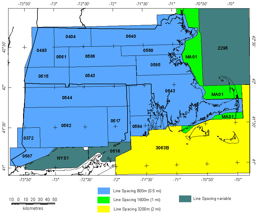
Southern New England (MA, CT, RI) Aeromagnetic and Shipborne Magnetic Projects
|
|
Data Type* |
|
|
|
|
|
|
|
|
|
| 0322 | A | Brookhaven ARMS '58 1 | USGS | 10/1958-11/1958 | 1 mi. | E-W | 500 AG |
3000
|
Total field, arbitrary datum | see footnote1 |
| 0343 | A | Brookhaven ARMS '59 1 | USGS | 06/1959-07/1959 | 1 mi. | E-W | 500 AG |
3725
|
Total field, arbitrary datum | see footnote1 |
| 0344 | A | Rowe ARMS '59 1 | USGS | 10/1959-11/1959 | 1 mi. | E-W | 500 AG |
6800
|
Total field, arbitrary datum | unpublished |
| 0372 | A | Danbury reflight | USGS | 08/1960 | 1 mi. | E-W | 500 AG |
320
|
Total field, arbitrary datum | USGS GP-364-369 |
| 0384C | A | Rowe ARMS South '60 1 | USGS | 07/1960-09/1960 | 1 mi. | E-W | 500 AG |
200
|
Total field, arbitrary datum | USGS OF72-459 |
| 0404 | A | Massachusetts Coop '61 | USGS | 09/1961 | 1 mi. | E-W | 500 AG |
544
|
Total field, arbitrary datum | USGS GP-429-438 |
| 0413 | A | Brookhaven ARMS '60 1 | USGS | 10/1959-11/1959 | 1 mi. | E-W | 500 AG |
4700
|
Total field, arbitrary datum | see footnote1 |
| 0493 | A | Massachusetts Coop '62 | USGS | 08/1962 | 0.5-1 mi. | E-W | 500 AG |
785
|
Total field, arbitrary datum | USGS GP-448-461 |
| 0515 | A | Massachusetts Coop '63 | USGS | 08/1963 | 1 mi. | E-W | 500 AG |
710
|
Total field, arbitrary datum | USGS GP-526-537 |
| 0516 | A | Long Island Sound | USGS | 6 Profiles | variable | variable | 500 AG |
295 |
IGRF? | unpublished |
| 0517 | A | Connecticut Coop '63 | USGS | 06/1963 | 1 mi. | E-W | 500 AG |
720
|
Total field, arbitrary datum | USGS GP-539-547 |
| 0543 | A | Massachusetts Coop '65 | USGS | 04/1965-05/1965 | 1 mi. | E-W | 500 AG |
1200
|
Total field, arbitrary datum | USGS GP-617-624,629-635 |
| 0544 | A | Connecticut North '65 | USGS | 05/1965 | 1 mi. | E-W | 500 AG |
1700
|
Total field, arbitrary datum | USGS GP-583-596,640-653 |
| 0560 | A | Massachusetts Coop East | USGS | 12/1965 | 0.5 mi. | E-W | 500 AG |
930
|
Tot. field, arbitrary datum | USGS GP-702-710 |
| 0561 | A | Massachusetts Coop West | USGS | 12/1965 | 1 mi. | E-W | 500 AG |
450
|
Tot. field, arbitrary datum | USGS GP-625-628 |
| 0562 | A | Connecticut South '65 | USGS | 12/1965 | 1 mi. | E-W | 500 AG |
2800
|
Tot. field, arbitrary datum | USGS GP-816-819,843-879 |
| 0564 | A | Rhode Island Fault | USGS | 12/1965 | 0.5 mi. | E-W | 500 AG |
885
|
IGRF? | USGS OF72-459 |
| 0585 | A | Boston South | USGS | 11/1966 | 0.5 mi. | E-W | 500 AG |
1500
|
Total field, arbitrary datum | USGS GP-673-679,760-767 |
| 0586 | A | Quabin | USGS | 11/1966 | 1 mi. | E-W | 500 AG |
840
|
Total field, arbitrary datum | USGS GP660-668,697-701 |
| 0587 | A | Bridgeport | USGS | 11/1966 | 1 mi. | E-W | 500 AG |
460
|
Total field, arbitrary datum | USGS GP-820-827 |
| 0640 | A | Fitchburg 2 | USGS | 06/1968 | 0.5 mi. | E-W | 400 AG |
3486
|
Total field, arbitrary datum | USGS GP-712-743 |
| 0643 | D | Massachusetts Coop '68 | USGS | 07/1968 | 0.5 mi. | E-W | 400 AG |
5408
|
Total field, arbitrary datum | USGS GP-770-814 |
| 2295 | Grid | Gulf of Maine | several | several | variable | variable | variable |
? |
? | Macnab and others, 1990 |
| 3063B | D | Offshore East Coast - NY | LKB | 11/1974-02/1975 | 2 mi. | NW-SE | 1500 B |
18400 |
IGRF 1965 | Behrendt & Klitgord, 1979 |
| MA01 | A | Western Gulf of Maine (BE-A2) | Aero Service | 9/1975-11/1975 | 1 mi. | N-S | 1500 B |
7850 |
IGRF 1968 | Weston Geophysical Research, 1976 |
| NYS1 | A | Long Island Sound, Ship Mag. | USN | ? | variable | variable | Sea Level |
?
|
? | Heirtzler, 1970 |
Description of Table Columns:
* Files of most digitized analog contour maps may be downloaded from the USGS site: http://pubs.usgs.gov/of/1999/ofr-99-0557/html/mag_home.htm (U.S. Geological Survey, 1999)
** For more complete references see Hill (1991).
|| Top || Page 1 || Compilation || Processing || Index Maps || State Magnetic Maps || Gravity Map || Download data || References ||
USGS Links - || USGS - Eastern Minerals Team || USGS - Geology Discipline || USGS - Home Page ||
[an error occurred while processing this directive]