

Aeromagnetic Survey Index Map and Data Table of Vermont and New Hampshire
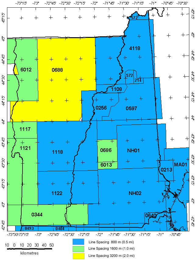
New Hampshire and Vermont Aeromagnetic Projects
| No* | Data Type | Survey Name | Flown By | Date Flown | Flight Spacing | Flight Dir | Flight Altitude | LineMi | Datum | Publication** |
| 0213 | A | Berwick '55 1 | USGS | 09/1955 | 0.5 mi. | E-W | 750 AG |
800
|
Total field, arbitrary datum | USGS GP-136,137 |
| 0214 | A | New Hampshire Coop North 2 | USGS | 09/1955 | 0.5 mi. | N-S | 750-2500 AG |
1100
|
Total field, arbitrary datum | USGS GP-138,139 |
| 0256 | A | New Hampshire West 2 | USGS | 07/1956-08/1956 | 0.5 mi. | E-W | 2300 B |
2450
|
Total field, arbitrary datum | USGS GP-194-196 |
| 0344 | A | Rowe ARMS '59 | USGS | 10/1959-11/1959 | 1 mi. | E-W | 500 AG |
6800 |
Total field, arbitrary datum | USGS OF72-459 |
| 0384B | A | Rowe ARMS East '60 2 | USGS | 07/1960-09/1960 | 1 mi. | E-W | 500 AG |
2900
|
Total field, arbitrary datum | USGS OF72-459, USGS GP-358r |
| 0404 | A | Massachusetts Coop '61 | USGS | 09/1961 | 1 mi. | E-W | 500 AG |
544
|
Total field, arbitrary datum | USGS GP-429-438 |
| 0493 | A | Massachusetts Coop '62 | USGS | 08/1962 | 0.5-1 mi. | E-W | 500 AG |
785
|
Total field, arbitrary datum | USGS GP-448-461 |
| 0572 | A | Northern New Hampshire '66 2 | USGS | 06/1966 | 0.5 mi. | N-S | 3500 B |
2800
|
Total field, arbitrary datum | USGS GP-654-656 |
| 0597 | A | North-central N.H. '66 | USGS | 12/1966 | 0.5 mi. | E-W | 5500 B |
1800 |
Total field, arbitrary datum | USGS GP-891 |
| 0638 | A | North-central N.H. '68 3 | USGS | 05/1968 | 0.5 mi. | E-W | 5000 B |
1555
|
Total field, arbitrary datum | USGS GP-891 |
| 0640 | A | Fitchburg 4 | USGS | 06/1968 | 0.5 mi. | E-W | 400 AG |
3486
|
Total field, arbitrary datum | USGS GP-712-743 |
| 0642 | A | Central New Hampshire '68 | USGS | 07/1968 | 0.5 mi. | E-W | 5000 B |
970
|
Total field, arbitrary datum | USGS GP-892 |
| 0686 | A | New Hampshire Coop '70 3 | USGS | 06/1970 | 1 mi. | E-W | 5000 B |
1055
|
Total field, arbitrary datum | USGS GP-892 |
| 0688 | A | Vermont Regional | USGS | 06/1970-07/1970 | 2 mi. | E-W | 4000 B |
740
|
IGRF65 | USGS OF72-459 |
| 0706A | A | New England Regional North 5 | USGS | 03/1971 | 2 mi. | E-W | 4000 B |
1690
|
IGRF65 | USGS OF72-459 |
| 0706B | A | New England Regional South 5 | USGS | 03/1971 | 2 mi. | E-W | 4000 B |
1645
|
IGRF65 | USGS OF72-459 |
| 1108 | D | Sherbrooke-Lewiston '81 | USGS | 09/1981 | 0.5 mi | E-W | 300 AG |
162 |
IGRF80 | USGS OF85-501 |
| 1117 | D | Glens Falls A '83 | USGS | 10/83 | 1 mi | E-W | 1000 AG |
795 |
IGRF80 | USGS OF02-361 |
| 1118 | D | Glens Falls B '83 | USGS | 10/83 | 0.5 mi | E-W | 300 AG |
4210 |
IGRF80 | USGS OF02-361 |
| 1121 | D | Glens Falls A '84 | USGS | 5/84-6/84 | 1 mi | E-W | 1000 AG |
2115 |
IGRF80 | USGS OF02-361 |
| 1122 | D | Glens Falls B '84 | USGS | 5/84-6/84 | 0.5 mi | E-W | 300 AG |
2990 |
IGRF80 | USGS OF02-361 |
| 4118 | D | Sherbrooke-Lewiston '82 | QEB | ?/1982 | 0.5 mi | E-W | 500 AG |
7360 |
IGRF80 | USGS OF85-501 |
| 6012 | D | Central Lake Champlain | Texas Instruments. | 9/75-11/75 | 1.25 mi | E-W | 400 AG |
780 |
? | Texas Instruments (1976) |
| 6013 | D | Western Portland | Texas Instruments. | 9/75-11/75 | 1.25 mi | E-W | 400 AG |
530 |
? | Texas Instruments (1976) |
| MA01 | A | Western Gulf of Maine 6 (BE-A2) | Aero | 9/1975-11/1975 | 1 mi. | N-S | 1500 B |
7850 |
IGRF65 | Weston Geophysical Research, 1976 |
| NH01 | A | Central New Hampshire 6 (BE_B!) | Aero | 06/1976-10/1976 | 0.5 mi. | N-S | 3000 B |
3189
|
IGRF65 | Weston Geophysical Research, 1976 |
| NH02 | D | Southern New Hampshire 6 (BE_B2) | Aero | 06/1976-10/1976 | 0.5 mi. | E-W | 3000 B |
6869
|
IGRF65 | Weston Geophysical Research, 1976 |
Description of Table Columns:
No.: Internal USGS project identification number
Data Type: Data collected as: A=Analog, D=Digital
Survey Name: Internal project name (not always the
name used in publication title)
Flown By: Company or government agency who
flew the original survey
Flight Spacing and Flight Dir.: Primary
flight-line spacing and primary flight-line direction
Flight Altitude: Flight altitude in feet; B =
barometric elevation, AG = above ground draped over topography
LineMi.: Approximate total of line miles
flown for this survey
Datum: Indicates if a regional field was removed
and, if it could be determined, the base value removed. Total field = no
regional was removed. Arbitrary datum = the base value removed was not
stated on the map.
Publication: Brief publication reference**.
USGS paper contour map publications are for analog surveys. Geophysical
Investigations Maps = GP-yyyy, Open-file Maps = yy-zzz, Miscellaneous
Field Investigations= MF-zzz, refers to all or part of the original project
area.
* Files of most digitized analog contour maps may be downloaded from the USGS site: http://pubs.usgs.gov/of/1999/ofr-99-0557/html/mag_home.htm (U.S. Geological Survey, 1999)
** For more complete references see Hill (1991).
|| Top || Page 1 || Compilation || Processing || Index Maps || State Magnetic Maps || Gravity Map || Download data || References ||
USGS Links - || USGS - Eastern Minerals Team || USGS - Geology Discipline || USGS - Home Page ||
[an error occurred while processing this directive]