

Map of Coastal
Vulnerability
 |
The Virgin Islands National Park
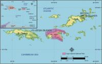 |
| Figure 1. Location of Virgin Islands National Park, St. John, U.S. Virgin Islands. Click on figure for larger image. |
The beautiful tropical coast of Virgin Islands National Park encompasses most of the island of St. John in the US Virgin Islands (Figure 1). The Virgin Islands are part of an arcuate chain of islands that form the northern and eastern boundaries of the Caribbean Sea, separating it from the Atlantic Ocean. The Puerto Rico - Virgin Island microplate, believed to be derived from oceanic crust of the Caribbean plate, stretches from eastern Hispaniola to the Virgin Islands, and lies 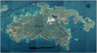 |
| Figure 2. Virgin Islands National Park on St. John Island. Click on figure for larger image. |
along the boundary of the Caribbean plate and the North American plate (Rankin, 2002). Cretaceous volcanism produced most of the rocks seem on St. John including basalts, andesite, and keratophyre. Lesser amounts of calcareous rocks and cherts contribute to the complex geology of this rugged 49 km² island (Rankin, 2002).
St. John has a maximum height of 390 m (1280 ft) above sea level, and slopes steeply to beaches and headlands along the coast (Figure 2). Much of the coastline of St. John is paralleled by shallow fringing reefs which are vulnerable not only to expected sea-level rise acceleration, but also to hurricane damage, increased water temperature, runoff and sedimentation from adjacent land, boat anchoring, coral disease, and bottom fishing (for more information on coral reefs in the US Virgin Islands see: http://biology.usgs.gov/s+t/SNT/noframe/cr134.htm). In addition to the many natural and biologic resources on St. John, there are also a number of cultural resources within the park including ancient petroglyphs and Danish sugar plantation ruins.
|
|