USGS Open File Report 2004-1400
sunillum.tif - sun illuminated color image of the 150 grid of the Puerto Rico Trench.

sunillum.tif - sun illuminated color image of the 150 grid of the Puerto Rico Trench

Metadata also available as - [Questions & Answers] - [Parseable text] - [XML]

Metadata:


Identification_Information:
Citation:
Citation_Information:
Originator: National Oceanic and Atmospheric Administration (NOAA)
Originator: The U.S. Geological Survey (USGS)
Publication_Date: 2004
Title:
sunillum.tif - Sun Illuminated Color Image of the 150 meter grid of the Puerto Rico Trench
Geospatial_Data_Presentation_Form: remote-sensing image
Series_Information:
Series_Name: Open-File Report
Issue_Identification: 2004-1400
Publication_Information:
Publication_Place: Woods Hole Science Center, Woods Hole, MA
Publisher: U.S. Geological Survey Coastal and Marine Geology Program
Other_Citation_Details:
Puerto Rico Trench Project Probes Legs I and III: 24 September - 30 September, 2002; and 28 August - 4 September, 2003, respectively relative to Leg II.
Online_Linkage:
<http://pubs.usgs.gov/of/2004/1400/data/multibeam/sunillum/sunillum.zip>
Larger_Work_Citation:
Citation_Information:
Originator: Uri ten Brink
Originator: Castle Eugene Parker
Originator: William Danforth
Originator: Chris Polloni
Originator: Toshi Uozumi
Originator: Glynn Williams
Publication_Date: 2004
Title:
Project PROBE Leg II - Final Report and Archive of Swath Bathymetric Sonar, CTD/XBT and GPS Navigation Data Collected During USGS Cruise 03008 (NOAA Cruise RB0303) Puerto Rico Trench 18 February - 7 March, 2003
Series_Information:
Series_Name: Open-File Report
Issue_Identification: 2004-1400
Publication_Information:
Publication_Place: Woods Hole Science Center, Woods Hole, MA
Publisher: U.S. Geological Survey, Coastal and Marine Geology Program
Online_Linkage: <http://pubs.usgs.gov/of/2004/1400>
Description:
Abstract:
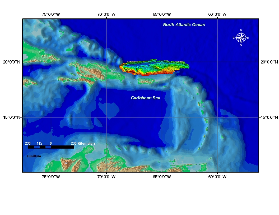
Geologic features in the Puerto Rico trench are remotely sensed, monitored, collected, studied, and analyzed. This data set was colorized by depth and converted to sun illuminated raster imagery; it was collected and processed during the U.S. Geological Survey science cruise 03008 in collaboration with National Oceanic and Atmospheric Administration Research Cruise RB0303 from 18 February to 7 March 2003, Leg II of III. (Leg I and III: 20020924 to 20020930 and 20030828 to 20030904, respectively).
Purpose:
This sun illuminate image is used in Geographic Information Science, i.e. discipline, which uses Geographic Information Systems as a tool to understand features in the trench and make interpretations of the geologic/bathymetric aspects therein. The intentions of this data set are to provide qualitative and quantitative visual information about the trench so that natural hazards such as earthquakes and tsunamis can be better understood.
Time_Period_of_Content:
Time_Period_Information:
Multiple_Dates/Times:
Single_Date/Time:
Calendar_Date: 200302
Single_Date/Time:
Calendar_Date: 200302
Single_Date/Time:
Calendar_Date: 200303
Single_Date/Time:
Calendar_Date: 200304
Currentness_Reference: ground condition
Status:
Progress: Complete
Maintenance_and_Update_Frequency: None planned
Spatial_Domain:
Bounding_Coordinates:
West_Bounding_Coordinate: -68.9
East_Bounding_Coordinate: -62.6
North_Bounding_Coordinate: 20.3
South_Bounding_Coordinate: 18.7
Keywords:
Theme:
Theme_Keyword_Thesaurus: General
Theme_Keyword: U.S. Geological Survey
Theme_Keyword: USGS
Theme_Keyword: National Oceanic and Atmospheric Administration
Theme_Keyword: Coastal and Marine Geology Program
Theme_Keyword: CMGP
Theme_Keyword: NOAA
Theme_Keyword: NOAA Office of Ocean Exploration
Theme_Keyword: NOAA Hydrographic Survey-Atlantic Branch
Theme_Keyword: Woods Hole Science Center
Theme_Keyword: WHSC
Theme_Keyword: seafloor mapping
Theme_Keyword: field activity serial number 03008
Theme_Keyword: field activity number RB03-02
Theme_Keyword: NOAA Cruise RB0303
Theme_Keyword: Seabeam
Theme_Keyword: Multibeam bathymetry
Theme_Keyword: shaded relief multibeam image
Theme_Keyword: color encoded bathymetry image
Theme_Keyword: psuedo-color coded bathymetry image
Place:
Place_Keyword_Thesaurus: General
Place_Keyword: North America
Place_Keyword: Atlantic Ocean
Place_Keyword: Caribbean Sea
Place_Keyword: Muertos Trough
Place_Keyword: Anegada Trough
Place_Keyword: Antilles Arc
Place_Keyword: Virgin Island Trough
Place_Keyword: Caribbean Plate
Place_Keyword: Archipelago
Access_Constraints: None
Use_Constraints:
Public domain data from the U.S. government are freely redistributable with proper metadata and source attribution. Please recognize the U.S. Geological Survey (USGS) and National Oceanic and Atmospheric Administration (NOAA) as the source of this information.
Point_of_Contact:
Contact_Information:
Contact_Organization_Primary:
Contact_Organization: U.S. Geological Survey
Contact_Person: Glynn Williams
Contact_Position: Spatial Data Technician
Contact_Address:
Address_Type: mailing and physical address
Address: 384 Woods Hole Road
City: Woods Hole
State_or_Province: MA
Postal_Code: 02543-1598
Country: USA
Contact_Voice_Telephone: (508) 548-8700 x2290
Contact_Facsimile_Telephone: (508) 457-2310
Contact_Electronic_Mail_Address: gwilliams@usgs.gov
Hours_of_Service: 8:00AM to 5:00PM: M-F
Native_Data_Set_Environment:
Microsoft Windows 2000 Version 5.1 (Build 2600) Service Pack 2; ESRI ArcCatalog 8.3.0.800

Data_Quality_Information:
Positional_Accuracy:
Horizontal_Positional_Accuracy:
Vertical_Positional_Accuracy:
Lineage:
Source_Information:
Source_Citation:
Citation_Information:
Publication_Date: 2004
Title: SeaBeam MB41 raw data files
Geospatial_Data_Presentation_Form: raster digital data
Type_of_Source_Media: disc
Source_Time_Period_of_Content:
Time_Period_Information:
Range_of_Dates/Times:
Beginning_Date: 20020924
Ending_Date: 20020930
Source_Currentness_Reference: ground condition
Source_Citation_Abbreviation: SeaBeam
Source_Contribution:
The raw data files were processed to create a bathymetric mosaic
Source_Information:
Source_Time_Period_of_Content:
Time_Period_Information:
Range_of_Dates/Times:
Beginning_Date: 20030218
Ending_Date: 20030407
Source_Currentness_Reference: ground condition
Process_Step:
Process_Description:
The data pipeline included transferring the SeaBeam MB41 raw data files from the SGI computer to a processing laptop via file transfer protocol (FTP). The raw files were converted using Caris 5.3 Hips Sips software. The processing crew maintained the same processing procedures as employed by NOAA hydrographic field units. Once the data was converted, a Digital Terrain Model was generated for visual detection of artifacts and missed depths. The next step entailed reviewing and editing the data with Caris Swath Edit, followed with Caris Sub Set mode editing. Both editing processes allowed the hydrographer to eliminate data points that were considered artifacts or out of context with the immediate benthic area. After editing, the weighted mead grid was re-generated with a grid resolution of 150 meters. A color scale by depth with sun illumination model at elevation 30 and azimuth 45 was exported as a tif image with an associated world file.
Process_Date: 2004
Process_Contact:
Contact_Information:
Contact_Person_Primary:
Contact_Person: Castle E. Parker
Contact_Organization: NOAA/EASC
Contact_Position: Hydrographer
Contact_Address:
Address_Type: mailing and physical address
Address: 439 West York Street
City: Norfolk
State_or_Province: Virginia
Postal_Code: 23510
Country: USA
Contact_Voice_Telephone: 757-441-6746
Contact_Facsimile_Telephone: 757-441-6601
Contact_Electronic_Mail_Address: castle.e.parker@noaa.gov
Process_Step:
Process_Description:
Renamed the image file from PRT03_150interp_rnbwPRT3045.tif to sunillum.tif and reduced from 24bit to 8bit color depth with associated world file.
Source_Used_Citation_Abbreviation: PRT03_150interp_rnbwPRT3045.tif
Process_Date: 2004
Source_Produced_Citation_Abbreviation: sunillum.tif
Process_Contact:
Contact_Information:
Contact_Person_Primary:
Contact_Person: Chris Polloni
Contact_Organization: U.S. Geological Survey
Contact_Position: Information Specialist
Contact_Address:
Address_Type: mailing and physical address
Address: 384 Woods Hole Road
City: Woods Hole
State_or_Province: MA
Postal_Code: 02543-1589
Country: USA
Contact_Voice_Telephone: (508) 548-8700 x2280
Contact_Facsimile_Telephone: (508) 457-2310
Contact_Electronic_Mail_Address: cpolloni@usgs.gov
Hours_of_Service: 9AM to 5PM; M- F
Process_Step:
Process_Description:
This image's coordinate system was re-assigned from a UTM Zone 19, NAD83 to a Geographic, Geodetic Model: WGS84 using Blue Marble's Geographic Transformer (Version 5.1).
Source_Used_Citation_Abbreviation: sunillum.tif
Source_Produced_Citation_Abbreviation: sunillum.tif
Process_Contact:
Contact_Information:
Contact_Person_Primary:
Contact_Person: Glynn Williams
Contact_Organization: U.S. Geological Survey
Contact_Position: Spatial Analyst
Contact_Address:
Address_Type: mailing and physical address
Address: 384 Woods Hole Road
City: Woods Hole
State_or_Province: MA
Postal_Code: 02543-1598
Country: USA
Contact_Voice_Telephone: (508) 548-8700 x2290
Contact_Facsimile_Telephone: (508) 457-2310
Contact_Electronic_Mail_Address: gwilliams@usgs.gov
Hours_of_Service: 8:00AM to 4:30PM; M-F

Spatial_Data_Organization_Information:
Direct_Spatial_Reference_Method: Raster
Point_and_Vector_Object_Information:
SDTS_Terms_Description:
SDTS_Point_and_Vector_Object_Type: String
Point_and_Vector_Object_Count: 80
Raster_Object_Information:
Raster_Object_Type: Pixel
Row_Count: 2103
Column_Count: 5417
Vertical_Count: 1

Spatial_Reference_Information:
Horizontal_Coordinate_System_Definition:
Geographic:
Latitude_Resolution: 0.000010
Longitude_Resolution: 0.000010
Geographic_Coordinate_Units: Decimal degrees
Geodetic_Model:
Horizontal_Datum_Name: D_WGS_1984
Ellipsoid_Name: WGS_1984
Semi-major_Axis: 6378137.0
Denominator_of_Flattening_Ratio: 298.25722356300003
Planar:
Planar_Coordinate_Information:
Planar_Coordinate_Encoding_Method: row and column
Coordinate_Representation:
Abscissa_Resolution: 0.001438
Ordinate_Resolution: 0.001355
Vertical_Coordinate_System_Definition:
Altitude_System_Definition:
Depth_System_Definition:

Entity_and_Attribute_Information:
Detailed_Description:
Entity_Type:
Entity_Type_Label: Band_1
Entity_Type_Definition: color scale image with sun illumination stored in TIFF format
Entity_Type_Definition_Source: ESRI
Attribute:
Attribute_Label: ObjectID
Attribute_Definition: Internal feature number.
Attribute_Definition_Source: ESRI
Attribute_Domain_Values:
Unrepresentable_Domain:
Sequential unique whole numbers that are automatically generated.
Attribute:
Attribute_Label: Value
Attribute:
Attribute_Label: Red
Attribute:
Attribute_Label: Green
Attribute:
Attribute_Label: Blue

Distribution_Information:
Distributor:
Contact_Information:
Contact_Person_Primary:
Contact_Person: Uri ten Brink
Contact_Organization: U.S. Geological Survey
Contact_Position: Research Scientist
Contact_Address:
Address_Type: mailing and physical address
Address: 384 Woods Hole Road
City: Woods Hole
State_or_Province: Massachusetts
Postal_Code: 02543-1589
Country: USA
Contact_Voice_Telephone: (508) 548-8700
Contact_Facsimile_Telephone: (508) 457-2310
Contact_Electronic_Mail_Address: utenbrink@usgs.gov
Hours_of_Service: 8AM to 5 PM; M-F
Resource_Description: Downloadable Data: Open-File Report 2004-1400: sun illuminated
Distribution_Liability:
Although this dataset has been used by the National Oceanic and Atmospheric Administration (NOAA) and the U.S. Geological Survey (USGS), no warranty, expressed or implied, is made by NOAA or the USGS as to the accuracy of the data and/or related materials. The act of distribution shall not constitute any such warranty, and no responsibility is assumed by NOAA or the USGS in the use of these data or related materials.
Standard_Order_Process:
Digital_Form:
Digital_Transfer_Information:
Format_Name: TIFF
Format_Version_Number: 3.2
Format_Specification: GeoTIFF Image
Format_Information_Content:
The four files (sunillum.tif, sunillum.tfw, sunillum.prj, and sunillum_metadata.txt)
File_Decompression_Technique: zip
Transfer_Size: 0.000
Digital_Transfer_Option:
Offline_Option:
Offline_Media: DVD-ROM
Recording_Capacity:
Recording_Density: 4,700
Recording_Density_Units: Mbyte
Recording_Format: UDF
Compatibility_Information:
The user must have a computer system with a DVD-ROM available. To browse the information contained on this DVD-ROM, the user must have a current WWW browser available. The user must also have software installed on their computer to unzip the archived file.
Fees: none
Technical_Prerequisites:
The user must have a program capable of reading and processing "geotiff" images.

Metadata_Reference_Information:
Metadata_Date: 20041214
Metadata_Contact:
Contact_Information:
Contact_Organization_Primary:
Contact_Organization: U.S. Geological Survey
Contact_Person: Glynn Williams
Contact_Position: Spatial Data Technician
Contact_Address:
Address_Type: physical address
Address: 384 Woods Hole Road
City: Woods Hole
State_or_Province: Massachusetts
Postal_Code: 02543-1598
Country: USA
Contact_Voice_Telephone: (508) 548-8700 x2290
Contact_Facsimile_Telephone: (508) 457-2310
Contact_Electronic_Mail_Address: gwilliams@usgs.gov
Hours_of_Service: 8:00AM to 5:00PM; M- F
Metadata_Standard_Name: FGDC Content Standards for Digital Geospatial Metadata
Metadata_Standard_Version: FGDC-STD-001-1998
Metadata_Time_Convention: local time
Metadata_Access_Constraints: None
Metadata_Use_Constraints: None
Metadata_Extensions:
Online_Linkage: <http://www.esri.com/metadata/esriprof80.html>
Profile_Name: ESRI Metadata Profile

Generated by mp version 2.8.18 on Fri Dec 17 16:08:20 2004