
|
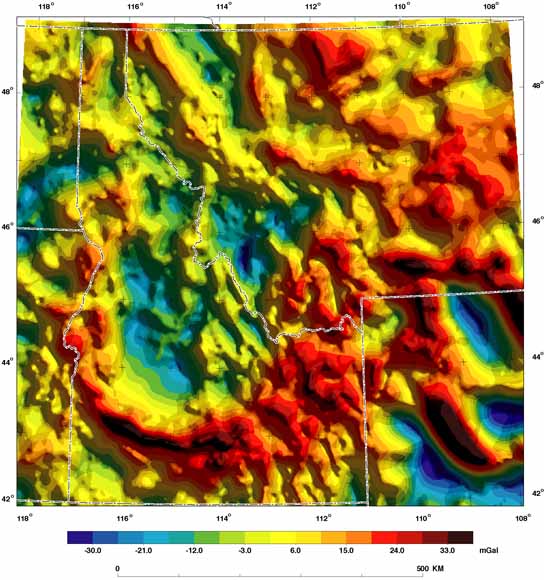
Isostatic residual gravity anomalies in the study area (from fig. 4) |
|
Geophysical (potential-field) data can provide an efficient means of delineating subsurface geology and structure over areas at varying scales. We are using regional aeromagnetic and gravity surveys, and their various derivative maps, to investigate the geologic and tectonic framework of the Columbia-Missouri Rivers headwaters region, which encompasses the Northern High Plains and the Northern Rocky Mountains. The major focus of the project is to develop regional digital earth science data and interpretations that can be used by Federal land managers in regional planning and special assessments such as roadless-area withdrawals. The study area encompasses all lands managed by the U.S. Forest Service in Idaho north of the Snake River Plain and in western Montana. Geophysical techniques can delineate major crustal boundaries and deep crustal structures that may be localizing mineral deposits and controlling regional fluid flow. These techniques are particularly useful for investigating areas that are covered by thick, surficial deposits. Our purpose here is to describe, briefly, techniques to enhance particular anomaly characteristics (for example, trend or wavelength), present the resulting maps, and suggest ways in which they may prove most useful. In-depth interpretations are deferred to subsequent publications. |
Text
Read the readme file (8 KB)
Go to the Report folder for the report as a 34-page PDF document (of2004-1413.pdf; 57.2 MB) and the readme file
Go to the Metadata folder (512 KB)
Data
Go to the ESRI folder for two zip files and the readme file (35.8 MB)
Go to the GeoSoft folder (26.3 MB), includes the readme file
Go to the USGS folder (32.8 MB), includes the readme file
For questions about the content of this report, contact Edward Mankinen.
| Help
| PDF help
| Publications main page | Open-File
Reports for 2004 |