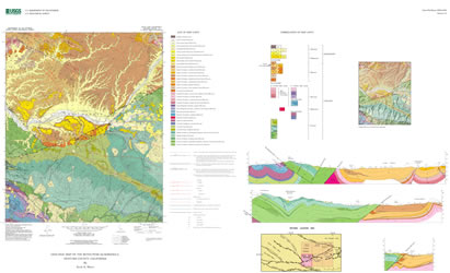
| New 1:24,000-scale geologic mapping in the Cuyama 30Í by 60Í quadrangle, in support of the U.S. Geological Survey (USGS) Southern California Areal Mapping Project (SCAMP), is contributing to a more complete understanding of the stratigraphy, structure, and tectonic evolution of the complex junction area between the NW-trending Coast Ranges and EW-trending western Transverse Ranges. The 1:24,000-scale digital geologic map of the Reyes Peak quadrangle, located in the eastern part of the Cuyama map area about 75 km northwest of Los Angeles, is the final of six contiguous 7 ˝Í quadrangle geologic maps compiled for a more detailed portrayal and reevaluation of geologic structures and rock units shown on previous maps of the region. The Reyes Peak map shows the surface distribution of Eocene through Miocene marine sedimentary rocks and Miocene through Quaternary terrestrial sedimentary rocks and sediments. The map documents structural details of three major tectonic faults -- the Big Pine, Pine Mountain, and Ozena faults -- and several large folds, including the regionally extensive Piedra Blanca syncline. Structural interpretations of the map-area subsurface are depicted in three cross sections. |