
|
|
|
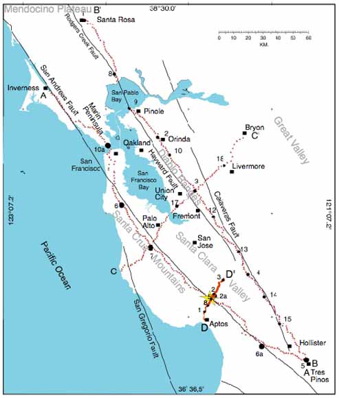
In May 1991 and 1993, following the 1989 M 7.1 Loma Prieta Earthquake, the U.S. Geological Survey (USGS) acquired four land-based, controlled-source seismic refraction profiles in the San Francisco Bay Area, California. The seismic profiles were acquired to help calibrate the Northern California Seismic Network (NCSN), to determine the local crustal- and upper-mantle velocity structure in the region, and to determine the effect of crustal and upper-mantle structure on seismic wave propagation from the Loma Prieta epicentral area. However, of the three primary objectives of the 1991 and 1993 land-based seismic surveys, only two of the objectives, calibration of the NCSN network and examination of wave propagation from the epicentral area, were fully realized. The NCSN network accurately located the 1991 and 1993 seismic shot points to within hundreds of meters, suggesting that the network was reasonably accurate in locating local earthquakes. The structure of the crust and upper mantle along the San Francisco Peninsula was found to focus seismic energy northward, and likely contributed to the significantly stronger shaking in the San Francisco and Oakland areas during the 1989 Loma Prieta earthquake. However, the other three seismic profiles acquired along and across the greater Bay area in 1991 and 1993 were never fully analyzed, and velocity models for the profiles have not been previously published. The USGS has recently renewed efforts to examine the effect of crustal velocity structure on seismic wave propagation, amplification, and attenuation throughout the San Francisco Bay area. To further accomplish the original goals of the 1991 and 1993 seismic surveys and to aid the current investigations, we developed 2-D tomographic crustal- and upper-mantle velocity models for each of the four seismic profiles. In this report, we present tomographic velocity models and travel time and geometry data for each profile of the 1991 and 1993 seismic profiles. Because of the areal coverage, the volume of data, and the known locations of shots and receivers, travel times from these surveys should be useful in developing more accurate regional 3-D crustal velocity models of the Bay area. For each of the seismic profiles, first-arrival (P-wave) travel times from inline shots to seismographs along the seismic profiles have been measured, and the travel times between the shot and receiver pairs have been checked against their reciprocal pairs (where possible) to ensure accuracy. Such checks on reciprocity are needed for most of the seismic profiles because the highly urban environment resulted in low signal-to-noise ratios on a number of the 1991 and 1993 shot gathers. Thus, regional velocity models of the San Francisco Bay area that include travel times from the 1991 and 1993 seismic profiles should utilize the travel times presented in this report versus travel times without reciprocity checks. |
Download this report as a 32-page PDF document (of2004-1423.pdf; 688 KB)
For questions about the content of this report, contact Rufus Catchings
| Help
| PDF help
| Publications main page | Open-File
Reports for 2004 |