Discussion
The geophysical evidence and modeling results, which suggest the lens can be interpreted as a 60-m-thick layer of salt, can be summarized as follows. Polarity information, preserved by wavelet processing, indicates that the high-amplitude anomaly (lens) is associated with a low-impedance layer. True-amplitude-processed data are used to compute the normal-incidence reflection coefficient, approximately -0.2. Salt, overpressured shale, or gas-saturated sediments are all possible rock types corresponding to such a value. AVO analysis yields a low density, about 2.2 g/cc, and demonstrates an amplitude decrease with respect to increasing offset. These relations decrease the probability that the high-to-low impedance layer is either overpressured shale or gas-saturated sediments, respectively. Modeling results indicate a single lens, of 60 m maximum thickness, thinning to less than 20 m in a 10-km distance. The lack of diffractions at the edge of the anomaly suggests that the unit is not an igneous intrusion. So, although no single observation or analysis is conclusive, the collective analyses indicate a high probability that the low-impedance layer is bedded salt.
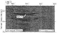
The upper surface is smooth on the profiles we analyzed (Figures 3 a,b,c), and the smoothness is indicative of an autochthonous nature for the lens (Wu and others, 1990b). Its thin, continuous character suggests that it was probably deposited early in the development of Baltimore Canyon Trough prior to the time of ocean crust formation and related subsidence which resulted in the influx of marine waters. The laterally continuous thinning pattern, more abrupt on the landward side, is suggestive of deposition in an early pre-ocean spreading rift basin, possibly fault bounded on the landward end. Unfortunately, the base of the layer is not resolvable on our records because of interference patterns and peg-leg multiple problems. Nor is the velocity of the underlying strata resolvable due to the short cable length used for acquisition. However, the underlying strata are undisturbed and the lens does not exhibit any diffractions at the edges, and so there is not any indication of salt mobilization.
Usually, much thicker salt deposits are present in early rift environments. Buffler (1989) described the separation of salt basins in the Gulf of Mexico during the late Jurassic, when a narrow band of oceanic crust was emplaced with early (basement-) faulting controlling the updip limit of thick salt. Diapiric structures off the Atlantic coasts of the United States, Canada, around the North Atlantic and extending down as far south as offshore Morrocco are thought to have originated in a massive deep salt layer related to the early phase of North Atlantic rifting (Pautot, and others, 1970; Holser and others, 1988). Growth faults have developed in many of these areas, for example, the Gulf of Mexico (Buffler, 1989; Wu and others, 1990b) and the Carolina Trough offshore the U.S. east coast (Dillon and others, 1982), related to salt mobilization and withdrawal of these thicker (original) units.
This salt anomaly in the Baltimore Canyon Trough differs, as well, from one in Georges Bank Basin (Anderson and Taylor, 1980; Lee and others, 1991) in terms of thickness and mode of emplacement. The Georges Bank salt is an intrusive feature surrounded by limestone and other evaporites (Lee and others, 1991). That feature is about 9 km wide, about 350 m thick, and is imaged as two troughs with a 60-ms separation. The edges of the feature also are quite different. There is a higher peak amplitude with edge diffractions in the Georges Bank feature as opposed to the smoother edges of the Baltimore Canyon Trough anomaly.
The structure and geophysics of the Baltimore Canyon Trough salt lens indicate a thin (about 60 m), broad (25 km) autochthonous feature, which was deposited relatively rapidly in one of a series of rift basins along the Atlantic margin. The thinness suggests it was probably in one of the peripheral pre-spreading basins. The 25-km width is well within the range of at least 35 km of pre-spreading extension seen in the northern Red Sea (Cochran and Martinez, 1988).
The smoothness of the layer top and undisturbed nature of the encasing strata are indicative of a lack of mobilization. The lack of flow may be due to one reason or a combination of reasons. The flat lens may have lacked dip, which would have induced gravity-driven flow. The density contrast between the lens and the overburden may have been too small to create a buoyancy force sufficient to cause the lens to flow. A small density contrast could result from two causes: - the layer may not be pure salt, but intermixed with sediments, or
- the layer may be predominantly salt, but so thin that the pressure gradient resulting from the gravitational instability is not sufficient to drive the flow.
|