
Digital Mapping Techniques '04— Workshop Proceedings
U.S. Geological Survey Open-File
Report 2004–1451
GML Encoding of NADM C1
1Geological Survey of Canada, 490 de La Couronne, Québec, G1K 9A9 Canada;
e-mail: eboisver@nrcan.gc.ca
2U.S. Geological Survey, 954 National Center, Reston, VA 20192, U.S.A.
3CSIRO, ARRC, PO Box 1130, Bentley, WA 6102, Australia
4Geological Survey of Canada, 615 Booth Street, Ottawa, K1A 0E9, Canada
*Members of NADM DITT (Digital Interchange Technical Team)
Abstract
The North American Geologic Map Data Model Steering Committee’s (NADM) Digital Interchange Technical Team (see http://nadm-geo.org/) is tasked to create an interchange format compliant with the North American Geologic Map Data Model conceptual model, known as “NADM C1”. XML was unanimously selected as the technology of choice, and after initial attempts, it was realised that leveraging existing work on GML (Geographic Markup Language; OpenGis, 2004) would improve the interchange format. GML is a library that provides essential GIS features that can be reused in any geospatial application, such as NADM. GML provides reusable objects and design patterns. The NADM conceptual model has been analysed to create a GML application; this paper describes that process and provides examples of NADM GML encoding for interchange of geoscience data.
Introduction
In the latest report on this technical team (Digital Interchange Technical Team, 2003), we discussed the challenges of encoding the NADM conceptual model in an XML document. The process involved converting classes from the UML diagram into meaningful XML tags. We pointed out that the principal difficulty involved creation of a consistent logical schema (in UML), such that patterns in the schema could be mapped in a regular manner onto XML document structures, easing the transition from modeling to encoding. The solution to this problem came to us in the fall of 2003 at an international meeting in Edinburgh (Laxton and Brodaric, 2003), where it was decided that GML could be used to constrain and direct the XML encoding process, and thus that GML will be used as the encoding standard for sharing geological datasets among the participants (see http://ncgmp.usgs.gov/intdb/dmic/dmic-rep1.html). GML is itself an XML encoding of ISO standards designed to represent geographical features. Of importance to this discussion is the notion that GML provides a much needed design pattern which focuses encoding choices to a manageable subset of the very large set of choices possible in XML.
What is GML?
GML is the abbreviation for Geographic Markup Language. It is an XML encoding of an ISO feature model standard that describes classes required to represent common geospatial features (see Open GIS Consortium, 2004, for complete normative references). In the standard, there are descriptions for spatial objects (points, lines, polygons …), projections, dictionaries, topology, time, etc. The state of a geographic feature is described by properties, where each property is formed by a name, a type, and a value. GML is a framework, or a library, of reusable building blocks for any group that needs to create a “GML application”. GML by itself is not intended to be used directly, because it is domain neutral; it only describes geography, and there are only a small number of concrete feature types. To turn GML into a useful application, it must be expanded to describe the content in a specific domain, such as biology, forestry or geology. XMML is one example of such an application which extends GML to address specific issues of mining and mineral exploration (https://www.seegrid.csiro.au/twiki/bin/view/Xmml/WebHome/).
Why GML?
Several benefits can be obtained by adapting GML rather than starting with a new XML encoding. First, GML is an international standard developed by the Open GIS Consortium (OGC) that is currently being revised for publication as ISO 19136, being derived from a related set of international standards (the ISO 19100 series). It provides a formal development framework and comes with a large group of practitioners to help guide and support development. It also ensures that encodings developed in other domains can be reused by sharing common GML constructs. Some examples of reuse will be discussed later.
GML is also at the root of other standard technologies and protocols fostered by OGC. One important technology is WFS (Web Feature Service), which provides a mechanism for interaction with a geospatial database using GML. Software developed according to this standard can be reused for any GML encoding. By connecting to the GML community, we benefit from software vendors who support WFS in their server and client products. One possible scenario is to integrate information from various sources for decision making. Figure 1 shows a typical architecture of servers (on the left) translating their content into GML and serving the content through WFS to a GML-enabled client. Because the schemas are GML-based, the application can handle the common parts (the geography) without any prior knowledge of the domain.
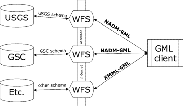 |
Figure 1. Example of a distributed system sharing geological information using
GML and WFS (Web Feature Service). |
GML also provides a “Design pattern” that is one of the most significant additions to our design process. Although the literature does not “sell” GML as such, the rules and constraints set by GML designers are a great help to any team working on XML schema design. GML in effect provides guidelines for consistent schema design. Without such rules and constraints XML (and UML) is almost too flexible, allowing many alternative ways to encode the same content, and requiring potentially different tools to be developed in order to read and manipulate the content. This implicit and understated aspect of GML proved to be of significant importance in our design process.
XML vs GML
It is important to realise that GML is XML. GML components are defined using XML schemas. An XML schema is a W3C standard that defines the structure of an XML document (see http://www.w3.org/XML/Schema/). We extend GML by using an XML schema that allows us to re-use tools from our first attempt to encode the NADM conceptual model in pure XML. GML provides a conceptual model based on the ISO feature model. A GML application must reuse core GML features defined in the conceptual model. Figure 2 shows a UML representation of a very simple example of a Street feature that we might want to model. The street inherits from the abstract GML feature and reuses standard GML spatial geometries and property structures for the new street features. By inheriting the Street from a GML Feature, we turned our street into a formal GML feature (the diagram reads “A Street is a kind of GML feature”).
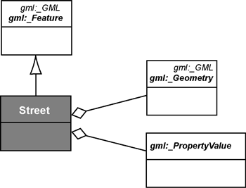 |
Figure 2. UML schema representing how GML components are reused in a specific
application. In UML, a line with a triangle can be read as “is a kind
of” and the lines with diamonds are read as “has.” This diagram is
read as follows: “A street is a kind of GML feature that has geometry and property.” |
However, GML also introduces design patterns, conformant with the General Feature Model defined in ISO 19109:
This snippet of GML code is an example of these encoding rules applied to the model depicted in Figure 3 (adapted from Galdos System Inc., 2003):
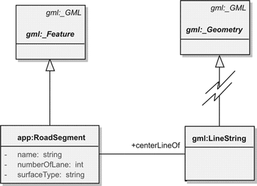 |
Figure 3. UML representation of a GML RoadSegment. RoadSegment inherits from
the abstract gml:_Feature, so a RoadSegment is a GML Feature. The RoadSegment declares a series of simple properties (numberOfLane, etc..) and a more
complex property named “centerLineOf” that relates to a complex geometric
feature from gml called LineString (which is a special kind of Curve)
that derives (through a series of intermediate geometry types) from
an abstract _Geometry class. |
<app:RoadSegment gml:id=“RS1”1>
<app:name>Handbury Road North</app:name>
<gml:centerLineOf2>
<gml:LineString gml:id=“L1”>
<gml:posList srsName=“# localCRS2a”>
1,2 2,3 3,4 4,0
</gml:posList>
</gml:LineString>
</gml:centerlineOf>
<app:numberOfLanes>2</app:numberOfLanes>
<app:surfaceType>Asphalt</app:surfaceType>
</app:RoadSegment>
[Note the typical
class (UpperCase “RoadSegment”)
property (lowercase “center LineOf”)
class (UpperCase “Line String”)
structure].
1Required ID.
2Since RoadSegment inherits from Feature, it can have 0 or more geometries. One
type of GML geometry is centerLineOf.
“app:” and “gml:” are namespace prefixes. The namespace mechanism provided by XML prevents “name clashing” when several schemas are brought together in the same document. In this case, the designer chose to create a <app:name> tag to hold the name, but a <gml:name> also exists in GML. To differentiate between those two elements, a namespace mechanism is used.
Another way to encode the same piece of information (Galdos System Inc., 2003) is:
<app:RoadSegment gml:id=“RS1”>
<app:name>Handbury Road North</app:name>
<gml:centerLineOf href=“#L1” />
This points to a LineString
<app:numberOfLanes>2</app:numberOfLanes>
<app:surfaceType>Asphalt</app:surfaceType>
<app:width uom=“m”>7.0</app:width>
< /app:RoadSegment>…
…
…
<gml:LineString gml:id=»L1»>This is the LineString, located further in document
<gml:posList srsName=”#localCRS2a”>1,2 2,3 3,4 4,0</gml:posList>
< /gml:LineString>
where “localCRS2a” is the value of an ID attribute on the definition of the coordinate-reference system.</app:name</app:RoadSegment>
Encoding of NADM C1
The NADM Data Model Design Team (DMDT) recently released version 1 of its conceptual model (C1), which is available at http://nadm-geo.org/. The model is described in a document containing UML diagrams, descriptions of classes, and accompanying text. The conceptual model is “implementation neutral”, in that it does not describe how it can be implemented in any specific technology, be it XML or in a relational database. Conversion of the conceptual model to an XML implementation first required adaptation of the conceptual model into a logical model expressed in a “GML-friendly” profile of UML, in preparation for formal encoding. This required: a) converting NADM C1 into a feature model, and b) replacing some specific UML structures with structures that are directly compatible with GML/XML. The main objective was to retain the original meaning of NADM C1 and to only reinterpret it for conversion to the GML application.
The Class-property model used in GML encoding is represented in a UML logical model (Figure 4) where:
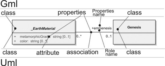 |
Figure 4. Representing GML using UML. The original UML diagram (top) is converted
in a GML-friendly representation (bottom). Changes are described in the
text. |
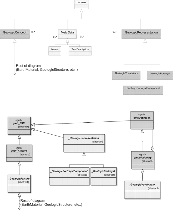 |
Figure 5. Adaptation of the top level of the model, essentially redirecting top
level classes from NADM C1 to GML. Top part is original NADM C1 while
bottom part is the GML interpretation. The original root of NADM C1 is
a concept called Universe, from which derives GeologicConcept, MetaData and GeologicRepresentation. GML offers an alternative set of root concepts
from which GML application must derive. For instance, GeologicConcept has been renamed _GeologicFeature to match GML syntax and now derives
from GML’s _Feature, which provides _MetaData functionalities. _GeologicRepresentation now derives from _GML, which is a high level abstract object. _GeologicVocabulary has been moved under GML _Dictionary, since this GML class offers the
functionalities GeologicVocabulary intended to offer. |
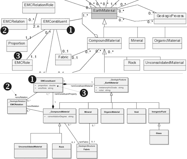 |
Figure 6. Reinterpretation of the conceptual model to conform to GML (and XML)
constraints. The top part of the figure is from the original NADM C1 document
while the bottom part shows adaptations to create a GML-friendly model.
Principally, NADM association classes are characterized as GML bridge
classes (see label #1), some NADM classes are characterized as GML complex
properties that are depicted as UML associations (see label #2), and some
NADM classes are characterized in GML as simple properties that are depicted
as UML attributes (see label #3). |
Several difficulties in GML encoding were encountered, for example:
The resulting GML code or implementation, although depicted as a UML model is not a representation of the original conceptual model, but rather is a model of the GML application in which model elements are derived from the GML classes and some relation types are interpreted as XML structures, e.g., aggregation implies nesting tags into another tag in the XML document. This is a very important distinction; the GML-friendly UML diagram is not an amendment or change to the official NADM C1 conceptual model. It is a tool that is used to bridge between the conceptual model and the GML application.
Shown on Figure 5 are structural changes to the hierarchy of NADM C1. In GML, all classes must inherit from core GML classes (_Object, _GML, _Feature). Therefore, top level classes of NADM C1 have been remodelled as descendents of GML features. Although multiple inheritance is allowed in UML, it is almost always suggested to avoid it in any kind of implementation, hence we did not keep the original top classes from NADM C1, but renamed the original GeologicConcept to _GeologicFeature. GML already provides the naming and documenting mechanism (_MetaData) so they don’t need to be duplicated in NADM C1 encoding. The GeologicVocabulary from NADM C1 takes advantage of the GML Dictionary that provides the same core functionality.
Figure 6 shows some typical examples of changes that were made:
In some instances, the adaptation was not trivial. For example, GeologicAge might be replaced by the more detailed encoding designed by the XMML group. The issue at this point is: do we keep the simple structure that NADM C1 proposes (follow the guiding principle of being consistent with NADM C1) or do we simply reuse XMML, which essentially is the same thing but uses a different vocabulary and is more detailed (so, we would not reinvent the wheel).
Example of a NADM GML document
This example sums up the discussion about GML encoding. The portion of the document (the full document is located at https://www.seegrid.csiro.au/twiki/pub/CGIModel/EarthMaterial/earthMaterial.xml) should be compared to our model depicted on Figure 7 (numbers correspond on document, comments and figure).
<?xml version=”1.0“ encoding=”UTF-8“?>
<NADM xmlns=”http://geology.usgs.gov/dm/NADM/v1.0“ xmlns:xsi=”http://www.w3.org/2001/XMLSchema-instance“ xsi:schemaLocation=”http://geology.usgs.gov/dm/NADM/v1.0 NADM-0_1.xsd“ xmlns:xlink=”http://www.w3.org/1999/xlink“>
<!-- Current max id number = 27 -->
<featureMember>
<Rock id=”nadm-1“> 1
<!-- Rock connected to a genetic event, w/constituent minerals -->
<name>Joe’s Granite</name>
<description>Intrusive rock</description>
<color>light gray</color>
<consolidationDegree>consolidated</consolidationDegree>
<emGenesis xlink:href=”earthMaterial.xml#nadm-19“/>
<emFabric> 2
<!-- fabric of Rock -->
<Fabric id=”nadm-26“>
<name>Fabric description</name>
<pervasiveness/>
</Fabric>
</emFabric>
<emConstituentProperty> 3
<EMConstituent id=”nadm-10“>
<!-- mineral w/ its own fabric -->
<proportion>35</proportion>
<emcRole>Mineral</emcRole>
<emConstituentMaterial>
<Mineral>
<name>Quartz</name>
<description>Silica</description>
<color>white</color>
<emFabric>
<Fabric>
<name>Aligned C-axes</name>
<pervasiveness>pervasive</pervasiveness>
</Fabric>
</emFabric>
</Mineral>
</emConstituentMaterial>
</EMConstituent>
</emConstituentProperty>
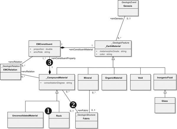 |
Figure 7. Example of a GML-compliant XML document with accompanying UML representation.
The numbers on the figure refer to the example document and the notes in
the text. |
The main points noted in this example are:
International activities
This activity is a contribution to a larger international project hosted by the IUGS Commission for the Management and Application of Geoscience Information (CGI) (see http://www.bgs.ac.uk/cgi_web/tech_collaboration/tech_collab.html). As stated there, “The overall objective of the Working Group is to develop international standards for the structure of geological information (i.e. data model standards) to enable interoperability among several national geological survey agencies.” (see http://www.bgs.ac.uk/cgi_web/tech_collaboration/data_model/data_model.html). The working group progress is documented at https://www.seegrid.csiro.au/twiki/bin/view/CGIModel/WebHome/.
Conclusion
Moving from generic XML encoding to GML has been beneficial for several reasons: a) it allowed encoding of the model to follow broadly accepted standards (ISO, OGC); b) it provided a much needed design pattern that resolved many consistency issues; and c) it opened NADM to other standards that are based on GML, such as WFS, and to other tool developers working with GML. As a by-product, encoding of the model was also an excellent review process and, for better or worse, generated a series of revision requests and comments to the NADM Data Model Design Team.
Acknowledgments
Peter Davenport, Andrée M. Bolduc and Kathleen Lauzière (Geological Survey of Canada) have kindly reviewed this manuscript. Dave Soller’s (U.S. Geological Survey) comments greatly improved this paper. Eric Boisvert has been financially supported by the Consolidation of Canadian Geocience Knowledge and Groundwater programs of the Earth Sciences Sector of Natural Resources Canada. Simon Cox’s contributions were supported by the Minerals and Energy Research Institute of Western Australia and the sponsors of project M340, and by the Open GIS Consortium. Boyan Brodaric was supported by Sustainable Development through Knowledge Integration and Consolidation of Canadian Geocience Knowledge programs of Earth Science Sector of Natural Resources Canada.
References
Digital Interchange Technical Team, 2003, XML Encoding of the North American Data Model, in Soller, D.R., ed., Digital Mapping Techniques ’03—Workshop Proceedings: U.S. Geological Survey Open-File Report 03–471, p. 215–221, accessed at http://pubs.usgs.gov/of/2003/of03-471/boisvert/index.html.
Galdos System Inc., 2003, Developing and Managing GML Application Schemas, http://www.geoconnections.org/developersCorner/devCorner_devNetwork/components/GML_bpv1.3_E.pdf.
Laxton J., and Brodaric, B., 2003, Data Model Collaboration Working Group Report, Edinburgh, Nov. 2003, accessed at http://ncgmp.usgs.gov/intdb/dmic/dmic.html.
North American Geologic-map Data Model Steering Committee, 2003, NADM Conceptual Model 1.0. A Conceptual Model for Geologic Map Information: preliminary website release under the auspices of the Geological Survey of Canada, the U.S. Geological Survey, and the Association of American State Geologists, accessed at http://nadm-geo.org/, now published and available at http://pubs.usgs.gov/of/2004/1334/.
OpenGIS Consortium, 2004, OpenGIS Geography Markup Language (GML) Implementation specification version 3.1, Cox et. al., ed.: OGC Document 03–105r1, accessed at http://portal.opengis.org/files/?artifact_id=4700.