
Digital Mapping Techniques '04— Workshop Proceedings
U.S. Geological Survey Open-File
Report 2004–1451
Oregon Statewide Geologic Map Data: A Pilot Project Where Digital Techniques Changed the
Geologic Map Compilation Process and Product
By Mark L. Ferns, Ronald P.Geitgey, Margaret D. Jenks, Lina Ma,
Ian P. Madin, Vicki S. McConnell, and Paul E. Staub
The Oregon Department of Geology and Mineral Industries (DOGAMI)
has begun a six-year project to digitally compile geologic data for the entire
state. This effort brings together the best available geologic mapping from
state and federal sources, student thesis work, and consultants. The project
will create a new statewide digitally-compiled geologic map coverage that will
become a component of the Geoscience Theme within the Oregon Framework Themes
(Figure 1). It will also improve the only digital statewide coverage, the 1:500,000-scale
state geologic map.
 |
|
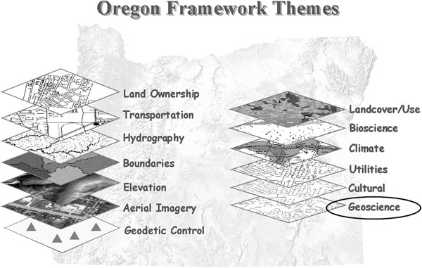
Figure
1. The Oregon Geographic
Information Council has identified for statewide development thirteen Framework
Themes. A workgroup for each theme is charged with developing a content
standard and implementation plan. Geoscience members are from state and
federal natural resource and transportation agencies, as well as academia.
The Geoscience Theme presently consists of Geology and Soils layers.
|
To accomplish this project, DOGAMI is working in partnership
with the USGS National Cooperative Geologic Mapping Program’s STATEMAP component
and the Oregon Geographic Information Council (OGIC). This partnership shares
the funding burden of this ambitious effort, and provides a review process
to ensure that the resulting data is consistent in structure, fully documented,
and serves the greatest number of potential users.
COMPILATION METHODOLOGIES
The following list of steps defines the usual way in which new
small scale geologic compilation maps have been produced in the past. This
process is referred to as “the conventional method”.
- Give the best available geologic maps to a geologist or team
of geologists.
- The geologist(s) then compiles a new, seamless map by drawing
new linework at a particular scale and assigning new unit labels to each
polygon.
- The new unit linework is then digitized and, based on the newly
written explanation of map units, the unit information is entered into a
database.
The DOGAMI compilation team decided to use a different method
to compile a new statewide digital map. This process is referred to as “the
Oregon Pilot method.” Many of the differences between this method and the conventional
method were driven by the expanded opportunities created by providing a digital-only
version of the map. The compilation team used the following list of steps to
make the statewide digital product, using the Oregon Pilot method.
- Digitize the original polygons/units for each of the
best available source geologic maps (Figures 2 and 3).
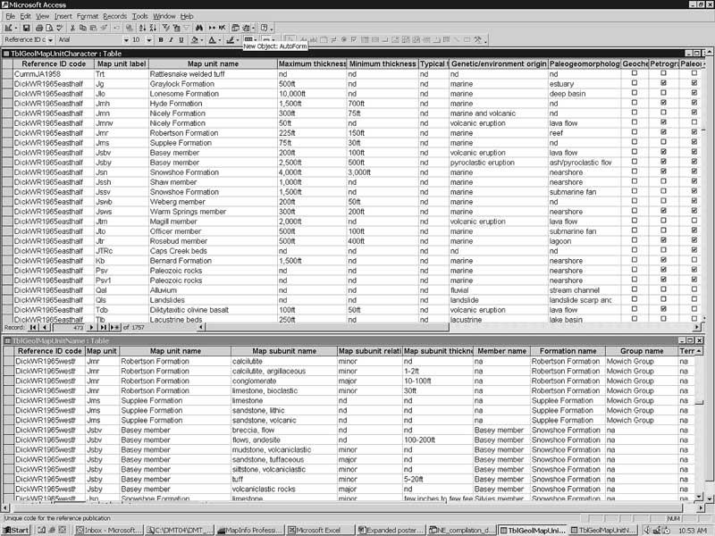
- Enter the information from the source map
author’s explanation of units, into a relational database (Figure 4).
- Rank
the maps in terms of the quality of the geological mapping and then decide
on the order of supersedure for appending the maps together. In this ranking,
a newer, 1:24,000-scale map by a professional geologist would replace an
area or part of an older map at a smaller scale or one created by a graduate
student.
- Put the best available polygonal/spatial information together
into a single layer, primarily using the more detailed or better quality
maps, but retaining the less detailed or poorer quality maps in areas where
no other coverage is available. This process creates an “appended” map that
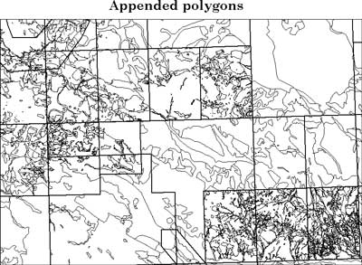
contains all of the best geologic unit polygons (Figure 5).
- Create new compilation
merge unit labels for each of the original source map unit polygons that
have been appended together in the map. These new labels effectively merge
the units from all of the different source maps into a coherent stratigraphic
or lithologic framework, thus creating “logical seamlessness” for the map.
Logical seamlessness occurs when a number of source datasets are integrated
into one and the resulting disjointed features are not edgematched (modified
geometrically) to fit together. Instead, these features are associated through
attributing (FGDC, 1995). The merge unit labels are based on the current
understanding of the geologic history of the area, as well as any new geochemical
analyses. Professional geologists, who have been working in and have a broad
understanding of the geology of a particular area of the state, assign the
compilation merge unit labels. Several types of compilation merge unit labels
can be made or modified to suit the end user’s needs, but the DOGAMI product
includes labels for geology, lithology and general geologic type (sedimentary,
volcanic, intrusive, etc.).
 |
|
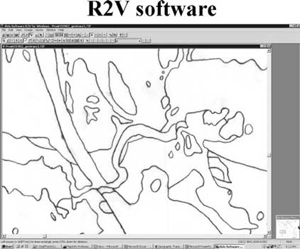 |
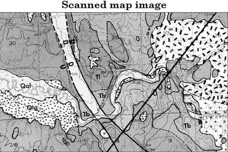
Figure 2. Image of part of a published geologic
map. Raster scanning yields a high resolution image which then is georeferenced
and projected prior to vectorizing the linework (image projection performed
using Blue Marble Geographics software).
|
|
Figure 3. Image of the traced/vectorized
linework from the geologic map shown in Figure 2. Conversion to vector
format is done through on-screen digitizing or through use of R2V software
(Able Software Corp.).
|
 |
|
Figure
4. Screenshot of two
of the Oregon Pilot method’s Microsoft Office Access database tables, showing
the typical data entry method and language.
|
Goals of the Oregon pilot
method
Several of the compilation team members have experience in making
compilation maps using the conventional methodology. Out of these experiences
grew the goals of the compilation project and therefore of the Oregon Pilot
methodology:
- New geologic information is always becoming available. Therefore,
the process must break free of a methodology that requires recompiling
the state’s geologic information from scratch every few years.
- As the complexity
of management decision-making increases, the need to factor in geologic
information becomes more widespread among different governmental agencies
and non-governmental organizations. The method must create a product that
is readily understood and can be easily used by a wide range of disciplines,
not just by geologists.
- The new Oregon Framework Themes process provides statewide coverage
of the best available information for each of the themes. Thus, the geologic
layer in that Framework must be capable of being constantly updated, in
order to provide the most current or “best” geologic information. The Oregon
Framework themes will serve not only state decision-making processes, like
the Oregon Department of Transportation’s siting of a new aggregate pit,
but possibly will also be useful to federal and local efforts.
- Geological science uses
complex, often difficult-to-understand vocabulary. To minimize confusing
terminology, we have limited the amount of non-mnemonic language in the database
information.
- The compilation map also must refrain from re-interpreting the
original authors’ map polygons or the explanation of units. Thus, maintaining
a linkage to the source maps and to their authors’ original interpretations
is a very important part of the methodology.
- The task of putting together
a new statewide layer, especially one that is accompanied by complex, descriptive
information, is arduous. Therefore, the method must take advantage of the
efficiencies of relational databases, i.e., the descriptive geologic information
in the original source map explanation is entered into the respective database
tables only one time for each unit.
Advantages and Disadvantages
Each of these two methods has advantages and disadvantages. Of
course, we chose to use the “new” Oregon Pilot method because we felt that
its advantages outweighed its disadvantages. The advantages and disadvantages
of each method are listed below.
Conventional method
Advantages
- It provides seamless, uniform coverage without “map faults” between
the different geologic interpretations and/or map scales.
- It is simple to
use because it contains only a single set of descriptive data for every
compiled map unit.
- It speeds up and simplifies the process of entering the digital
information because it requires entering only a single set of polygons
and a single set of map unit descriptors.
Disadvantages
- The map is not updateable. It is a snapshot of the best geologic
information available at a particular time. New mapping cannot be added
to it. Every new compilation project must start with the original source
maps.
- The varying quality of the geologic information is not transparent.
The compiled map does not necessarily retain either the original author’s
polygons or unit descriptions. The seamless coverage at a single, small scale
masks the areas of poor quality mapping.
- The final product is not flexible. The
compiled data and map unit labels result only in a single stand-alone,
conventional geologic map, not providing for other derivative map products.
- It is not
scaleable. The map is a single, fixed scale, and does not retain the
larger-scale, detailed information that may have been available in some of
the original source maps.
Oregon pilot method
Advantages
- It is updateable. New mapping can be added as soon as
it is completed, and any of the compilation merge unit labels can be easily
changed to reflect the new information and interpretation. To make a new
version of the compilation map, the method fits the new source geologic
maps into the previously appended mapping. Thus, the statewide compilation
map can be continuously modified/updated.
- It is transparent. The author’s original polygons and descriptive
explanation are in the database, and are always available to the end-user.
Digital versions of the original geologic maps, both as scanned images
and converted vectors, are part of the compiled map package. The compiled
map also clearly conveys the areas of lesser-quality, usually small-scale
mapping (see Figure 5). The obvious differences between areas of detailed
versus reconnaissance mapping can direct future mapping efforts to those
parts of the state with the most critical management issues, which may require
mapping of higher quality and resolution than currently available.
- It is flexible. Derivative geologic
or other types of maps can be made for any purpose. Users can easily modify
the compilation merge unit labels which DOGAMI geologists have assigned,
to fit their own stratigraphic or lithologic interpretations. Because the
map is intended for use as a digital product, the compilation merge unit
labels are not restricted to the length of typical geologic map unit labels
(i.e., Qal). Thus, more information, like lithology, formation, age, etc,
can also be conveyed in the compilation merge unit labels. Using period delimiters
in the merge unit labels allows them to be parsed into individual themes
that can then be made into their own derivative geologic maps.
- It is scaleable.
Because it retains the original source map’s information, those areas of
the state that contain detailed (1:24,000) information from the original
map can be used at that scale; while the compilation merge unit labels create
maps that are more appropriate for intermediate-scale (e.g., 1:100,000) and
small-scale (1:250,000 or greater) usage.
 |
|
Figure
5. Screenshot of polygons
appended from various source maps into the draft digital compiled map.
Bold, rectangular lines are the neatlines of original geologic maps. Fine
lines are appended polygon boundaries.
|
Disadvantages
- It produces a seamed coverage with obvious
“map faults”, or seams, between areas of differing original geologic
interpretations and/or source map scales. Edgematching among the units of
the original source maps is only addressed by the compilation merge unit
labels.
- It is not a static product, so at any point in time there is
no single, official “Geologic Map of the State of Oregon”. Rather, versioned
databases will be periodically released to keep the state’s digital geologic
coverage as up-to-date as possible.
- It is more difficult for the casual,
non-professional audience to access and use the information. The digital
seamed coverage requires that the user be capable of choosing the type of
derivative map product that they want to produce, as well as the map scale
displayed.
- It is not easily printable in its entirety. Local and regional
land and resource management projects are the intended audience for the
digital product. The entire statewide layer is too large and detailed to
be printed at a single scale, and on a single sheet of paper.
- The final digital product
varies in quality from one area of the map to another. The older source
maps, and their explanations of map units that are entered into the database,
often contain information that is from previous, now discarded, generations
of geologic interpretation. However, they are still used in the compiled
map because they are the best available information for that particular area.
- A large volume
of information must be digitized at the beginning of the compilation process.
The final digital product is a patchwork of many geologic maps instead
of a single coverage; many sets of unit descriptions are attached to the
merged polygons instead of a single set of unit descriptions.
Role of digital concepts
As noted earlier, the digital concepts and techniques that are
available now, such as raster-to-vector conversion (R2V) and relational databases,
were a driving force behind our ability to create the Oregon Pilot method.
Our choice to produce a digital-only statewide compilation product changed
the way that we looked at compilation mapping and therefore led to the differences
between the Oregon Pilot method and the conventional method. Some of those
conceptual and methodological changes are listed below.
- Digital maps do not have to be made at a particular scale and
do not have to be printable on standard paper sheet sizes. Thus, they can
include a range of different-scaled mapping.
- Digital techniques make it easy to
convert maps individually into digital products and then splice or append
them together to make the final single layer of polygons. This simplicity
allows the Oregon Pilot method to carry along, unchanged, the original source
map linework and unit descriptions. Without the digital methodology, the
compilation work would be forced to revert to the old method of drawing completely
new linework and writing a new explanation of units.
- Compact digital storage
media (e.g., DVDs) now have sufficient capacity to store scanned and digitized
original maps as well as a final, single, appended statewide digital map
layer. Thus, the original source maps, which may be out-of-print or difficult
to access, are more easily available to the end-user.
- Most federal, state, and local
governments use GIS systems to make management decisions. These entities
need a digital geologic coverage that is as detailed as possible, and that
can be easily understood by non-geologists. The appended source maps provide
the best available spatial information at the largest possible scale and
the greatest detail, while the new compilation merge unit labels provide
the most current geologic interpretation.
- Digital geologic data can be layered with other
digital spatial themes to provide a more complete understanding of a project
area or a management issue. Thus, the digital product makes both the original
source maps, and the compiled and merged data, more accessible to the end-user.
REFERENCES
Federal Geographic Data Committee, 1995, Development
of a National Digital Geospatial Data Framework, section 5.2 Technical Context,
accessed at http://www.fgdc.gov/framework/framdev.html.
SOFTWARE VENDOR CONTACT
INFORMATION
Able Software Corp., 5 Appletree Lane, Lexington, MA 02420-2406
Blue Marble Geographics, 345 Water Street, Gardiner, Maine 04345
Microsoft Corporation, One Microsoft Way, Redmond, WA 98052-6399
RETURN
TO Contents