2005-1127
The San Andreas Fault In The San Francisco Bay Area, California:
A Geology Fieldtrip Guidebook To Selected Stops On Public Lands
By Philip W. Stoffer

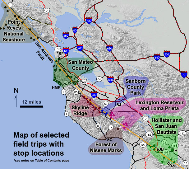
Above: Small dots within colored areas show the location of stops discussed in chapter field guides. Abbreviations
for locations
include San Francisco (SF), San Jose (SJ), Hollister (H), San Juan Bautista (SJB), Half Moon Bay (HMB),
Pacifica (P), and
Santa Cruz (SC). The orange line represents the San Andreas Fault (SAF) section that ruptured in
the Great San Francisco
Earthquake of 1906.
| Abstract This guidebook contains a series of geology fieldtrips with selected destinations along the San Andreas Fault in part of the region that experienced surface rupture during the Great San Francisco Earthquake of 1906. Introductory materials present general information about the San Andreas Fault System, landscape features, and ecological factors associated with faults in the South Bay, Santa Cruz Mountains, the San Francisco Peninsula, and the Point Reyes National Seashore regions. Trip stops include roadside areas and recommended hikes along regional faults and to nearby geologic and landscape features that provide opportunities to make casual observations about the geologic history and landscape evolution. Destinations include the sites along the San Andreas and Calaveras faults in the San Juan Bautista and Hollister region. Stops on public land along the San Andreas Fault in the Santa Cruz Mountains in Santa Clara and Santa Cruz counties include in the Loma Prieta summit area, Forest of Nicene Marks State Park, Lexington County Park, Sanborn County Park, Castle Rock State Park, and the Mid Peninsula Open Space Preserve. Destinations on the San Francisco Peninsula and along the coast in San Mateo County include the Crystal Springs Reservoir area, Mussel Rock Park, and parts of Golden Gate National Recreation Area, with additional stops associated with the San Gregorio Fault system at Montara State Beach, the James F. Fitzgerald Preserve, and at Half Moon Bay. Field trip destinations in the Point Reyes National Seashore and vicinity provide information about geology and character of the San Andreas Fault system north of San Francisco. |
Contents of this Report
| Title Section -- 3 p. (109 kb) |
|
| Introduction -- 22 p. (2,106 kb) | |
| San Andreas Fault: An Overview Bay Area Faults and Earthquakes Comparison of the Bay Area earthquakes: 1906 and 1989 Comparison of Earthquake Magnitude and Intensity Scales Geologic Features of the San Andreas Fault A Geologic Time Scale Types of Faults Geomorphic Features Observable Along Faults Geomorphic Features Associated With Landslides Plant Communities of the San Francisco Bay Region |
|
| Field Trip to the Calaveras and San Andreas Faults: Hollister and San Juan Bautista Region -- 14 p. (731 kb) |
|
| Field Trip to Lexington Reservoir and Loma Prieta Peak Areas -- 14 p. (1,650 kb) |
|
| Forest of Nisene Marks State Park: Epicenter of the 1989 Loma Prieta Earthquake -- 2 p.(185 kb) |
|
| Lyndon Canyon and Ranch Lake Trail, Sanborn County Park --2 p. (608 kb) |
|
| Earthquake Trail, Sanborn County Park -- 13 p. (3,199 kb) |
|
| Field Trip to the Skyline Ridge Region in the Santa Cruz Mountains -- 13 p. (710 kb) |
|
| The San Andreas and San Gregorio Fault Systems in San Mateo County -- 21 p. (1,539 kb) |
|
| Geology at Point Reyes National Seashore and Vicinity -- 28 p. (1,532 kb) |
|
Complete report as single large file -- 133 p. (15, 811 kb) |
|
Direct questions and comments to:
Philip W. Stoffer
U.S. Geological Survey
Email to: pstoffer@usgs.gov
Phone (650) 329-5028
Download a current version of Acrobat
Reader for free
Help, PDF help, Publications main page, Open-File Reports for 2005
U.S. Department of the Interior, U.S. Geological Survey
URL: http://pubs.usgs.gov/of/2005/1127/
Maintained by Western Publications Group
Created: March 25, 2005
Last modified: March 25, 2005 (mfd)
Privacy statement | General disclaimer | Accessibility