Notes on Locating and Assigning
Intensities to the Shaking and Damage Descriptions in Lawson (1908)
These footnotes describe how the
damage and shaking reports from Lawson (1908) and other sources were used to
assign MMI intensities at specific sites. The difficulties of locating the more
obscure sites are also indicated. About 60% of the sites are footnoted. The
spreadsheet containing the site names,
locations, soil-types, page numbers in
Lawson (1908), our assigned MMI intensities, a grade for the intensity, and Toppozada and Parke's (1982) MMI
intensities can be downloaded.
1.
G.A. Waring reports “Near Agenda, in the lowlands, is a cracked
area nearly a mile from the river, probably along an old water course; while
sand craterlets are scattered through the orchards.”
We assigned MMI 7-8. Three miles northwest, “At Spreckels,
the movement caused much damage to flumes, sewers, and water-mains,” as well as
strongly damaging the 5-story sugar mill. We assigned MMI 8.
2.
Agnew State Hospital
was one of the most famous wrecks of the 1906 earthquake. 117 inmates and staff
were killed when the floors failed, and poor workmanship was widely alleged as
a cause. We assigned MMI 8.
3.
In Alameda, the
majority of the destruction “was confined to
the throw of chimneys and the
upper portions of brick walls.” A total of 619 chimneys fell throughout the
city. The large chimney at the oil works collapsed, in addition to the roof of
a two story building on Park Street. We assigned MMI 7-8.
4.
The Alameda County
Hospital at Fairmont is called "the County Hospital." It was only
slightly damaged; no chimneys were thrown down. We assigned MMI 6.
5.
At Albion, James Coyle
"was thrown violently to the ground, as were several cattle and horses that were grazing nearby. Large rocks were seemingly
squeezed out of the hillside and rolled into the river. Many houses and bridges
were thrown down." We assigned MMI 8-9.
6.
On Alcatraz Island, “A heavy shock was felt
Objects
were overturned in every direction.” We assigned MMI 6.
7.
F.E. Matthes reports that “the wagon bridge over Alder Creek,
which stood astride of the fault, is a complete wreck. The timbers broke in
many places, and the tension rods were twisted and in some cases actually
ruptured.” Rock slides and ground cracks were abundant from Alder Creek to
Irish Gulch. We assigned MMI 9.
8. Alexander Valley was the site of a bridge across the Russian River that was wrecked by the earthquake. There was extensive cracking on the eastern bank. We assigned MMI 8.
9.
Alma and Lexington
were inundated by the Lexington Reservoir. There was a large landslide at Alma.
We assigned MMI 8-9.
10.
The 1896 Post Office
map locates the Altruria Post Office north of Santa
Rosa, on the road to Mark West Springs. R.S. Holway
reports "cracks are said to have opened in the road, and springs to have
flowed for a short time." We assigned MMI 7. A mile west, at Fulton Road,
D. Butler notes that the damage was very slight. We assigned MMI 6-7.
11.
The Alum Rock Hotel
was located near the present Visitors Center for Alum Rock Park: "no
chimneys were damaged nor had any movable objects been overturned." We
assigned MMI 6.
12.
The Alameda Sugar
Company suffered the most damage in Alvarado. “A 6-inch cast-iron water
pipe
broke transversely about 30 feet above the ground,” and the two platforms
supporting the molasses tanks fell altogether, resulting in damage to the tanks
and the release of more than 1,000,000 pounds of molasses. Nearly all brick
chimneys in the village fell. We assigned MMI 8.
13.
Alviso suffered fallen chimneys, broken cornices, and cracked
walls. “Little serious damage of any kind was to be noted.” There was extensive
cracking and settlement in the area between Alviso
and Milpitas. We assigned MMI 7.
14. At Andersonia, the Ukiah Dispatch-Democrat reports “Chimneys were tumbled down, ... The earth has many wide fissures Tops of trees were shaken off, slides were thrown into Eel River, Indian Creek and along Southern Humboldt Lumber Co.’s railroad so that extensive repairs are necessary. The Southern Humboldt Lumber Co.’s dam is also damaged as well as telephone lines and mill. We assigned MMI 8.
15.
G.W. Fiscus reports that the damage in Annapolis was widespread.
Many buildings and bridges were wrecked, in addition to landslides and the
destruction of chimneys. The waters of the Gualala River were thrown out 50
and 60 feet. We assigned MMI 9.
16.
In Antioch, E.S.
Larsen reports that “about 25 percent [of the chimneys] needed repairing” and
that “out of about 12 brick buildings, the tower of the Catholic Church was
somewhat damaged, and one rickety old brick building fell. None of the good
buildings were damaged.” We assigned MMI 7.
17.
The Watsonville Pajaronian
reports that “the bluff near Aptos is badly cracked” and a chimney fell through
the roof of a summer home. G.A. Waring reports the
wagon and railroad bridges as undamaged. We assigned MMI 7. The Day Valley
Cemetery, located 0.6 miles north of the Watsonville Road, suffered moderate
damage. We assigned MMI 8.
18. The Arcata Union reports that “nearly 30 chimneys were toppled off” in the lower part of Arcata, and that the Union Hotel was “strained.” Neither the Arcata Union nor the Blue Lake Advocate mention the fissure that Lawson report claims “opened in one of the streets but by night it had closed again.” We assigned MMI 7.
19.
The Watsonville Pajaronian
reports that “the buildings on Stony Ford Ranch at Aromas
have been thrown
down, and the railroad track buried under rock hurled from the quarry.” We
assigned MMI 8-9.
20.
Baden Station was
incorporated into South San Francisco.
21.
Bald Hills Post Office
was renamed Elder Post Office in 1874.
22.
The intensities for
Bald Hills, Hower's, Martin's Ferry, Weitchpec, Orleans, Somes Bar,
Forks of the Salmon, Gilta Mine, and Brook Mine were
obtained from interviews conducted by a medical examiner, Mr. P.L. Young, who
only described the earthquake as either “felt” or “heavy.”
23.
In Bartlett Springs,
“nothing
was reported as having been knocked over, nor was any milk spilt
from pans.” We assigned MMI 5.
24.
In Bear Valley (San
Benito County), "the only noticeable effects ... were the swinging of
lamps and the disturbance of water surfaces." We assigned MMI 4-5.
25.
G.K. Gilbert reports
topped spruces in Bear Valley on Point Reyes, with 1/2 mile of the fault. Some
summer cottages sustained little damage other than fallen chimneys, but a barn
was wrecked. We assigned MMI 8-9.
26.
Beckwourth was renamed "Beckwith" by the US Post Office.
The Beckwourth Trail was discovered by Jim Beckwourth in 1850 and led from Reno through the Beckwourth Pass to the town of Beckwourth,
and then to Quincy and Marysville.
27.
Bell’s Station was
located 6 miles west of Pacheco Pass. “No damage was done beyond the loss of
milk. High bottles and dishes standing upon shelves were uninjured.” We
assigned MMI 5.
28.
Bellvale is called "Bellville" by S. Taber: it was a Post
Office on the road between La Honda and San Gregorio. There was a substantial
landslide that blocked the road. We assigned MMI 8.
29.
A majority of the
chimneys fell in Belmont, and “there were small landslides along the road leading
from Belmont to Crystal Springs Lake
In the foothills between Belmont and San
Mateo, the brick building of the Crocker Orphanage was completely ruined.” We
assigned MMI 7-8.
30.
In Benicia, T.J.J. See
reports that two or three houses collapsed and more than half of the city’s
chimneys were thrown down. At the entrance to the Arsenal grounds, the Gate
House (a round tower 12 feet in diameter, constructed of brick on a solid
foundation) suffered severe cracks in its walls. We assigned MMI 8.
31.
Bennett Valley lies to
the southeast of Santa Rosa. Only an "occasional chimney" was
damaged. We assigned MMI 6-7.
32.
The 1896 Post Office
map locates Berdan Post Office between Forest Ranch
and West Branch, but east of Cohasset.
33.
In Berkeley, A.C.
Lawson reports that “a large majority of brick chimneys were broken or overthrown,
several brick buildings had their upper walls
thrown down.” However, “the buildings on
the University Campus
sustained no serious damage.” We assigned MMI 7-8.
34.
In Berryessa
Valley, “The shock is reported to have been quite heavy on the level land of
the valley-bottom.” We assigned MMI 6-7.
35.
A sawmill owner
reported that there were no landslides on the road between the Big Basin and
Boulder Creek and that he had seen only one crack where the earth had begun to
slide. A separate report states that near the junction of the road leading from
Boulder Creek into the Big Basin, an old landslide from the previous winter had
been widened by the shock and its direction had changed. We assigned MMI 7.
36.
W.A. Chalfant reports an "unusual" but "untimed" length of shaking in Bishop. Doors and
windows were rattled. We assigned MMI 3-4.
37.
Black Diamond and
Cornwall were incorporated into Pittsburg.
38.
Blacks Station was
renamed Zamora.
39.
At Bloomfield, brick
buildings were wrecked and every chimney but one thrown down. Several frame
buildings were shifted on their foundations. 80% of the larger stones in the
cemetery fell. We assigned MMI 9.
40.
The Blue Lake Advocate reports that the
earthquake damaged 15 chimneys and cracked the plaster in many houses in Blue
Lake. We assigned MMI 6-7.
41.
In Bodega, all
chimneys were thrown down and several houses were shifted on their foundations.
A mile from town, a brick bark-drier was thrown into a heap, despite the
brickwork being bound together with iron rods. We assigned MMI 8. The Bodega
cemetery, situated on a hillside 0.3 miles south of town, was severely damaged.
We assigned MMI 9.
42.
The shock was
perceptible in Bodie and some clocks stopped. We
assigned MMI 2.
43.
In Bolinas, much of
the land was broken into blocks that have been faulted and tilted. “The upper
part of the village of Bolinas lies in a curving fault-sag among these dislocated
blocks
in the fault-sag, where the ground was much cracked, nearly all the
houses were either shifted or thrown from their foundations.” We assigned MMI
9.
44.
H.W. Fairbanks reports
that Boonville suffered no damage other than the collapse of “about half the
chimneys.” L. Romer remembers “the bricks on the
fireplace shaking loose and hitting the roof.” The Evergreen Cemetery, 1.5
miles north of town, was slightly damaged. We assigned MMI 7.
45.
B. Bryan reports “in
the town of Boulder Creek, all chimneys were down except those on some 1-story
cottages; these were cracked, however
and plaster was cracked everywhere.”
L.E. Titus, a young schoolteacher at the time of the earthquake, remembers that
many of the town’s buildings “were twisted and unsettled from their slight
foundations.” We assigned MMI 8.
46.
The descriptions of
effects at Boyes Hot Spring, Ceres, Esparto, Jamesan, the Pinnacles, and Thorn Junction are inadequate
for assigning intensities.
47.
J.M. Branscomb reported that 2 of 15 chimneys were “shaken down”
in the vicinity of Branscomb. The Willits News reports that the earthquake
caused a “dry shower of limbs and tree tops and the earth is cracked in several
places.” We assigned MMI 6-7. B. Barnwell reports that the shaking 6 miles west
on Branscomb Road threw down horses and cattle
standing on a hillside. We assigned MMI 8.
48.
The Blue Lake Advocate reports that “Briceland was more badly shaken up than Garberville. J.G.
Bowden’s store and Ben Harris’ hotel were both moved from their foundations,
J.P. Cannon’s house was wrecked badly and every breakable thing in the rooms
were destroyed; even the large range stove was broken to pieces.” We assigned
MMI 8-9.
49.
Most of the farms in
Bridgeport were damaged by the earthquake: a large landslide extended 150 feet
into the cultivated fields, and “a fissure at its foot was traceable for over
three miles.” A. Schafer describes how the shock “rolled her bed across the
room” and separated the house where the stairs were. We assigned MMI 8-9.
50.
The Blue Lake Advocate reports that “the
earthquake at Bridgeville did no serious damage
[but] the family of George W.
Cooper
were obliged to cook their morning meal by a campfire outside the
house, as their dwelling was minus chimney.” We assigned MMI 6-7.
51. Brook Mine is called "Brooks" by C.H. Johnson. Brook and Gilta were active mines in the Trinity Alps: however, the felt reports from these sites are secondhand. P.L. Young describes the shaking at Brook as "heavy," which would make it the only mine with MMI 6. We excluded this intensity.
52.
"In Brown's, Los Muertos, and Quien Sabe Valleys, the shock was only sufficient to throw cream
from pans of milk." We assigned MMI 5 to each of these sites.
53.
In Burlingame, many
poles along the line of the electric railway from San Mateo northward were
altered from their previously vertical positions. Many of the houses in the
Burlingame vicinity “were badly wrecked, due to the falling of extra heavy
chimneys through the roofs,” and most brick walls fell unless they were well
built. We assigned MMI 8.
54.
The Contra Costa Gazette reports “The
chimney inspection is closed in the Byron district: 119 dwellings were visited
by the inspector, aggregating 175 fire flues with only 4 condemned.” In Byron
Hot Springs, “One chimney and some plaster were cracked and a picture was
thrown from the wall.” We assigned MMI 6.
55.
Calaveras Valley was
inundated by the Calaveras Reservoir: "all the brick chimneys were thrown
down, tho there were only a few ...No damage to
houses is reported." We assigned MMI 7.
56.
C.E. Weaver reports
that in Calistoga, “a large number of chimneys and 2 brick buildings were
thrown down
A few local slides on the south side of Mount St Helena were
confined to the alluvium.” D. Patten reports “a large rock was thrown down from
cliffs up on the mountain
at an elevation of 4,000 feet on the northeast
side.” We assigned MMI 8.
57.
G.A. Waring reports “The intensity of the shock diminished
uniformly from Meridian toward Campbell. At Campbell, 68 per cent (51 out of
89) of the chimneys fell, but the plastering in the houses was not badly
injured.” We assigned MMI 7.
58.
Candelaria was an active mining area in western Nevada.
59.
The Cantara Post Office was located on the north side of the Cantara Railroad Bridge over the Upper Sacramento River,
the site of a derailment and chemical spill in 1991.
60.
Cantua Creek was crossed by an extensive landslide. The
association with the 1906 earthquake rests on the observation of S.C. Lillis,
who did not see the landslide occur, and G.D. Louderback's
characterization of the landslide face as “fresh”. We assigned MMI 6-7.
61.
The brick foundations
and water cisterns at the Cape Mendocino Light Station were broken. We assigned
MMI 8-9. The largest landslide triggered by the earthquake occurred at Cape Fortunas, 6 miles NNE. F.E. Matthes
described it as an earth-slump and concluded “It probably had long been
imminent before the earthquake started it.” We assigned MMI 8. The Blue Lake Advocate reports that “Capetown escaped with scarcely more serious results than a
lively shaking up.” We assumed this report disregards chimney damage and
assigned MMI 7-8.
62.
“Nearly all the
chimneys at Capitola fell, and considerable plaster was shaken from the north
walls of the first floor of the hotel
Much earth fell from bluffs near the
town, but there was no appreciable effect on the surf.” The railroad trestle, a
new steel structure, was also reported to be unsafe. We assigned MMI 7-8.
63.
In Caspar, the
majority of the wooden houses suffered no damage, and the lumber company’s
brick store sustained a few minor cracks. The bridge over the Caspar River and
the trestle over Jughandle Creek, however, were both
demolished and “all chimneys were broken without exception.” We assigned MMI 8.
64.
The Watsonville Pajaronian
reports that four homes in the Casserly School
District were severely damaged. We assigned MMI 8-9. On nearby Green Valley
Road, “a bunk house was shaken from its foundation.” We assigned MMI 8.
65.
The earthquake did not
seriously affect Castroville: only three out of approximately thirty chimneys
fell. We assigned MMI 6-7. At Neponset, 3 miles southwest, both the wagon
bridge and the railroad bridge across the Salinas River were damaged. We
assigned MMI 7-8.
66.
“At Cazadero the
shock was severe and chimneys were generally thrown, but no buildings were
wrecked, all the structures being of wood
Some pictures hanging against walls
were turned around so as to face the walls.” We assigned MMI 8.
67. Centerville and Decoto were both incorporated into Fremont. All the brick houses in Centerville were severely damaged and many of the walls were thrown down. Some of the walls the bank building fell and the roof caved in. The brick and tile chimneys were thrown with few exceptions, and the window panes of many stores broke as well. We assigned MMI 8. Only chimneys were damaged in Decoto. We assigned MMI 7.
68.
In Central San Joaquin
County, "no objects or chimneys were overthrown. Windows and window
weights rattled. Paper on the walls was cracked. The roof on a high church
tower was cracked ... large trees swayed and bent as if rocked by a terrible
gale." The township and range for this site locates it just northeast of
Stockton. We assigned MMI 5-6.
69.
The railroad yard at
Chittenden was severely damaged. “The cottage of the foreman was moved 5
inches westward; an upright piano was thrown northwestward upon its back, and
electric drop lights swung so as to break against the ceiling.” The porch of
the railroad office was ripped off and a 1,000 pound safe was knocked over.
Many freight cars were thrown off the tracks, and between Chittenden and the Pajaro Bridge “the track was bent in an S-shaped curve in
several places.” We assigned MMI 8-9.
70.
Cienega and Paicines occupy separate
valleys in "La Cienega de los Paicines." G.A. Waring
reports the shaking to be stronger at Paicines (MMI
6) than at Cienega (MMI 5). Four miles SW of Paicines, a man saw "a wave coming westward thru a grainfield, and some oaks waving considerably."
71.
All of the brick
chimneys in Cleone fell. Additionally, “all
sway-braces on the wharf had to be replaced, and the railroad track was buckled
in many places. The bridge across the lagoon sank 3 feet in some places, and
was thrown out of line laterally.” We assigned MMI 8.
72.
R.S. Holway reports that in Cloverdale, the upper walls of a
brick building had cracked so as to require rebuilding, but that a different
two-story brick building only exhibited cracked plastering. The inspector
condemned four-fifths of the town’s chimneys, but many agree that not more than
one-fourth fell. One man recounted seeing distinct waves in the ground. We
assigned MMI 7.
73.
In Coalinga, the walls
of a few brick buildings were slightly damaged, and the brick lining of the
furnace at an oil pumping station cracked. Although the oil wells and pipelines
were not damaged, considerable oil was thrown from the tanks. We assigned MMI
6.
74.
The largest building
in Collinsville, a hotel built on pilings, was completely destroyed, and the
chimneys and water-tanks were overthrown. We assigned MMI 8.
75.
Over 75% of the
monuments in the Holy Cross Cemetery at Colma were
thrown down or "twisted on their base." Both the Holy Cross train
station and the Cypress Lawn building were damaged. The other cemeteries in Colma were less severely damaged. We assigned MMI 8.
76.
The only brick
building in Concord was badly cracked. Most of the chimneys had also cracked,
and fifty per cent of the chimneys had fallen, including a large chimney at a
bakery. We assigned MMI 7.
77.
Congress Springs was
incorporated into Saratoga. A stone barn was thrown down, and people in houses
were knocked down trying to get out of doors. Chimneys and poorly built
foundations fell. We assigned MMI 8-9.
78.
Cooley's Landing was
near the western end of the Dunbarton Bridge.
"No damage but broken chimneys was noticeable ...One house on a poor
foundation was knocked down." We assigned MMI 7-8.
79.
Copeland Creek runs
through present Rohnert Park. R.S. Holway reports
"chimneys were much more damaged than on the road ... northward to Santa
Rosa. " We assigned MMI 7.
80.
The Santa Cruz Sentinel reports that in Corralitos, both
the Christian and Methodist churches were considerably damaged, along with two
houses and a winery. An elderly woman died of “a stroke of apoplexy brought on
by the fright caused by the earthquake.” We assigned MMI 8. Above Corralitos, an extensive landslide in Eureka Canyon dammed Corralitos Creek and blocked the county road. We assigned
MMI 8-9.
81.
At Corte Madera
"huge masses of rock had been thrown down" onto Alpine Road. We
assigned MMI 8-9.
82.
C.L. Jeffrey describes
the motion at Cotati as "objects were thrown southeast; hanging objects
swung northeast and southwest" but does not mention damage to chimneys or
buildings. Drury Butler describes a transit from Santa Rosa to the Copeland
district school, then Cotati, and the Durham district school, where "in
the valley the chimneys were as a rule thrown down." We assigned MMI 7.
83.
In Covelo, the
earthquake jarred objects from shelves and broke an unsecured window, but did
not damage any chimneys. B.L. Reed describes the shaking in Covelo as heavy. We
assigned MMI 6.
84.
At Crow’s Landing,
three out of eighteen chimneys fell and “considerable water was thrown from
the tanks.” The walls of a brick pumping station four miles north of Crow’s
Landing were cracked. We assigned MMI 6-7.
85.
Cuesta is called "Guesta" by
G.A. Waring: it was located along the railroad north
of Cuesta Pass and San Luis Obispo.
86.
Davis Mill became
Jenner. The earthquake threw down chimneys and damaged trestles on logging
railroads. We assigned MMI 8.
87.
Davisville was shortened to Davis. "Some plaster was cracked and
doors were jammed so they required resetting." We assigned MMI 5-6.
88.
J. Snider was part of
a road crew repairing the Laytonville Road, 1.5 miles south of Dos Rios. He
describes the shaking as strong, straining a barn where the crew was sleeping
and knocking down a large tree limb. We assigned MMI 7.
89.
Dove was located along
the railroad just southeast of Atascadero.
90.
Drews Valley was inundated by Drews
Reservoir.
91.
The damage in Dublin
consisted of a few broken chimneys and shifted water tanks, one of which fell
from its supports. We assigned MMI 6-7.
92.
Dudley Station was
located near the mouth of Cottonwood Canyon on present CA 41. "Nothing on
the shelves was disturbed, nor had milk or water slopt
over." We assigned MMI 3-4.
93.
At Duncan’s Mills, a
large hotel was completely ruined and several houses were thrown from their
foundations. J. Parmeter reports that the earthquake
forced up large trees that had been buried in the bed of the river, while
previously visible trees disappeared from sight, and “between the river and the
ruined hotel at Duncan’s is an irregular crack about 20 feet wide, 80 feet
long, and 1.5 to 4 feet deep
” We assigned MMI 8-9.
94.
Dungan’s Ferry was on the north shore of the Eel River west of Fernbridge, where an extensive lateral spread wrecked a
field. Similar lateral spreads occurred at Port Kenyon, Cock Robin Island, and
Cannibal Island. We assigned MMI 7-8.
95.
The shock at Edenvale was fairly strong, as shown by the damage done to
a brick canning factory. “All the walls were badly cracked and the tops of the
walls fell. The top of the fire-wall above the roof was shaken down.” We
assigned MMI 8.
96.
At El Jarro Point, “the shock was so light that a small chimney
with a terra-cotta top, making a height of seven feet above the roof, did not
fall
Glasses and bottles remained on the shelves in a bar-room.” We assigned
MMI 5-6.
97.
Milk was thrown from
pans a few miles north but not at Elkhorn Roadhouse. We used Elkhorn Ranch to
locate this site and assigned MMI 4-5.
98.
Elmhurst and Fitchburg
were incorporated into Oakland. Most of the chimneys fell at both sites, but no
structural damage was reported. We assigned MMI 7.
99.
The 1896 Post Office
Map locates Emmett Station 9 miles southeast of Paicines.
"Milk was thrown out in small quantities, but no movable objects were
upset or moved." We assigned MMI 5.
100.
Esmeralda is called
"Esmerelda." It was an active gold mine in
Calaveras County.
101.
In Eureka, “many
chimneys toppled over and several hundred panes of glass were broken
The
statue of Minerva on the dome of the court house tipt
toward the south until it leaned at an angle of 43°.” While one frame building moved twelve inches, no cracks
were caused in any of the brick buildings. The railroad bed sank at various
points between Samoa and Arcata. We assigned MMI 7.
102. The felt report for Eureka NV is problematic. In his introduction to the section “East of the Sierra Nevada,” G.D. Louderback asserts that Winnemucca was the furthest point east at which the earthquake was perceived. This would appear to preclude locating the Clay Simms report at Eureka, NV, as it is 93 miles east of Winnemucca. Lawson, however, includes the report, drawing the boundary of the Rossi-Forel Intensity II area in Map 23 through Eureka. We conclude that Simms’ letter was appropriately postmarked, but follow Stover and Coffman (1993) and disregard his report: first, because the earthquake was not felt in Tonopah, Gold Field, or Fairview, and second, because the reported duration (“it seemed to last about a second”) is entirely unlikely at this distance.
103.
“At Evergreen
all the chimneys, all the road
tanks, and nearly all of the wind-mills in the neighborhood fell. None of the
houses were demolished, but some were shifted on their foundations.” We
assigned MMI 8.
104.
G.K. Gilbert reports
that the towns from Sausalito to Fairfax “showed no damage more serious than
the loss of a portion of the chimneys
In San Anselmo
most of the brick chimneys were broken, but other injuries in that town and in
Fairfax appear to have been slight.” We assigned MMI 7 to Ross, Fairfax, and
San Anselmo.
105.
Fairoaks (San Mateo) was renamed Atherton. It suffered broken
chimneys and a collapsed (frame) bungalow. We assigned MMI 8.
106.
Fairoaks (Sacramento) was incorporated into Citrus Heights.
107.
Fairview is not
indicated on Map 23. The Fairview mining district in Churchill County, near the
1954 Fairview Peak earthquake, gives the best geographic fit to G.D. Louderback's enumeration, out of four candidate mining
districts in Nevada (see map of Nevada sites). Fairview did not feel the
earthquake.
108.
Two rockslides
occurred on the western end of southeast Farallon
Island. The Weather Bureau building was slightly damaged. We assigned MMI 7.
109.
Ferndale was strongly
damaged by the earthquake, but most of the damage was done to chimneys,
storefronts, and two brick buildings. One frame house was shifted on its
foundation. There was substantial liquefaction and lateral spreading throughout
the Eel River Valley. We assigned MMI 8.
110.
The Blue Lake Advocate reports that the
Vance Dairy Farm in Fieldbrook was strongly shaken, but
not damaged. We assigned MMI 6.
111.
Fields Landing had an
extensive lateral spread. We assigned MMI 7-8.
112.
J.F. McNamee describes
the shaking in Fishrock as strong, but his house was
not damaged. The Fishrock cemetery was moderately
damaged. We assigned MMI 8.
113. Forestville lost most of its chimneys. Clara Van Keppel remembers barrels of wine breaking in a winery, and the wine spilling out into the streets. A. Ross reports a ground crack in his orchard that took several years to close. The cemetery suffered moderate damage. We assigned MMI 7-8.
114.
Fort Bragg was
severely damaged. F.E. Matthes reports “Several brick
buildings were completely demolished; others had parts of the walls broken off.
Even a number of wooden buildings collapsed or were partly wrecked. Fire broke
out and devastated 1½ blocks before it could be controlled.” We assigned MMI 9.
115.
In Fort Ross, “chimney
tops were thrown off, some chimneys being shattered to the bottom. Many redwood
and pine trees were broken off, some at the ground, being uprooted; but
generally broken about halfway up.” Most buildings withstood the shock with
minimal damage, except “the old Russian Church and several other buildings
suffered through collapse of their underpinning
and a few frame buildings set
upon unbraced posts were shaken down.” We assigned
MMI 9.
116.
In Fortuna, store
windows were broken, merchandise tossed off shelves, furniture dislodged, and
over half of the town’s chimneys thrown down. “Several houses moved 1 to 3
inches off their foundations [and] the river water swashed up on the banks.” We
assigned MMI 7-8.
117.
The earthquake’s
effects in Fresno included “a general awakening of sleepers, oscillation of
chandeliers, stopping of clocks, and considerable agitation of trees
water in
troughs was spilt out.” The swaying of buildings was also reported, but this
motion only disturbed items without displacing them and damaged walls slightly.
We assigned MMI 5-6.
118.
The Blue Lake Advocate reports that in
Garberville, “only a few houses moved from their foundations a few inches,
Chimneys were shaken off the houses, and every fireplace was completely
demolished.” We assigned MMI 8.
119.
F.E. Matthes reports that the buildings at the Garcia Hot
Springs 6 miles east of the fault “suffered but slight damage.” We assumed
these buildings were cabins and assigned MMI 7-8.
120.
In Geyserville,
“several brick buildings were badly cracked and tops of fire walls thrown
down
half or more of the chimneys were reported down.” Neither the cemetery nor
the nearby bridge across the Russian River was damaged. We assigned MMI 7-8.
121.
In Gilroy,
"nearly every chimney fell, fire-walls of brick buildings were thrown
down." Monuments in both the Masons and Odd Fellows cemetery and the
Catholic cemetery fell. We assigned MMI 8.
122.
The majority of
chimneys in Glen Ellen were thrown down, and “one wall of a brick building
whose braces had been removed to make room for a stairway was much cracked.” We
assigned MMI 7-8.
123.
R.M. Hathaway reports
from Graton, “a place 3 miles northwest of Sebastopol,” that many frame
buildings were thrown from their foundations. The nearby Gilliam and Grass
Valley cemeteries show substantial damage. We assigned MMI 8-9.
124.
The Watsonville Pajaronian reports that a
Southern Pacific warehouse at Graves was “shaken to the ground.” We assumed
that the building was unreinforced and assigned MMI
7-8.
125.
Grayson suffered
little damage as a result of the earthquake, the only noticeable effects being
a few items tossed off of shelves. No chimneys were thrown down. We assigned
MMI 6.
126.
Greenwood was renamed
Elk. F.E. Matthes reports “weak underpinning caused
the partial collapse of several frame houses. Chimneys had fallen without
exception. Plaster fell in the lower stories of the few houses containing
plaster. The lumber mill was not damaged.” We assigned MMI 8-9.
127.
F.E. Matthes reports that “the wagon bridge over the Gualala
River was seriouosly damaged
all chimneys broke off;
plaster was cracked in the hotel and several other buildings; a few small
dwellings were thrown off their underpinnings.” We assigned MMI 8-9. In Gualala
Valley, along the fault trace, “the destruction was notably severe
” We
assigned MMI 9.
128.
R.S. Holway reports that all brick buildings were badly wrecked
in Guerneville, and that “chimneys generally fell.” The Commercial Hotel, a
frame building, was twisted slightly, and at the cemetery, one monument fell
and three or four others were shifted. We assigned MMI 8.
129.
Guth Landing was located near the present Shoreline
Amphitheatre. Chimneys were thrown down, and a brick warehouse was damaged. We
assigned MMI 7.
130.
Hacienda was the
residential community for the New Almaden Quicksilver
Mines, and was later called New Almaden.
131.
“In the town of Half Moon Bay many buildings
were badly damaged, some old frame houses and the brick bank building being
flat, while the upper half of a two-story brick structure was demolished.”
There was no evidence of any change in level along the coast. We assigned MMI
8.
132.
We have located the Hames Post Office at the Hames
Valley Hall.
133.
Hamlet was a small
town on the eastern shore of Tomales Bay with a pier
for milk trains. No buildings were damaged nor was the pier shifted, but a
large landslide disrupted a nearby section of the wagon road from Point Reyes
Station to Tomales. We assigned MMI 8.
134.
A. Kingsbury reports
that the damage in Hardy included thrown chimneys, movement of large
furniture, and damage to the logging railway. “The earth was cracked, both
upon the mountains and near the creek, where the earth was broken away from the
banks
the walls around the boilers in the lumber mill were cracked.” We
assigned MMI 8-9.
135.
At Healdsburg, most of
the chimneys fell. Five brick buildings were destroyed, "but many brick
buildings stood the shock without serious damage." Less than half the
cemetery monuments fell. There were fissures in the creek bed, and water was
forced up. We assigned MMI 8.
136.
Hemlock Post Office
was located between Ukiah and Upper Clear Lake.
137.
Hollister suffered the
collapse of three brick buildings and severe damage to the two-story Catholic
school and several other structures. “Sixty-five out of 123 chimneys fell, or
53 per cent.” It was reported that “a small peak near Santa Ana showed a
landslide down its steep face, plainly visible at a distance of six miles.” We
assigned MMI 8.
138.
Homestead was just
west of present Hillsdale: it is located on Map 21. The brick building of the
Crocker Orphanage was completely ruined. We assigned MMI 8.
139.
H. Willard reports
that “one big brick building” in Hopland was damaged and many objects were thrown
from shelves. The cemetery was slightly damaged. We assigned MMI 7.
140.
Horse Ranch and Middle
Fork Overlook are sites 20 miles NW and 10 miles SW of Round Valley where E.S.
Larsen describes significant ground cracking. We assigned these sites MMI 6-7,
half an intensity greater than the MMI 6 assigned to Covelo and Poonkinney.
141.
Hower's was a station on Redwood Creek below Bald Hills.
142.
The Fortuna Beacon reports that in Hydesville, “No great amount of damage was done except the
toppling over of chimneys. The stores suffered the breakage of glass ware and
crockery
The boiler in William’s mill was cracked
Two crevices in the earth,
each about six inches wide, opened a short distance from J. Rouse’s house.” We
assigned MMI 7.
143.
Idlewild was a station on the coast road at Little Sur River.
"Several articles were thrown from shelves" and "redwoods swayed
considerably." We assigned MMI 5-6.
144.
At "Idria, a few bottles and light articles were thrown from
shelves ...and a few bricks loosened ...but chimneys were not injured." We
assigned MMI 5-6.
145.
E. Pitts reports that
no chimneys were left standing in Inglenook, and many dishes were broken. Much
of the nearby timber fell. We assigned MMI 8-9.
146.
At Inverness, half the
houses "were shifted on their foundations. A number of persons were thrown
violently from their beds." G.K. Gilbert identified a consistent
fault-normal direction of “throw” from the fall of four water tanks. We
assigned MMI 9.
147.
In Irvington, “every
brick house was more or less extensively damaged; portions of walls fell in
some instances, and cracks in brickwork were common to all
Only a few chimneys
were left standing in the village. Plaster cracked and fell in large flakes in
several houses.” We assigned MMI 8.
148.
Isabella was inundated
by Lake Isabella.
149.
Jagel Landing was located east of Moffet
Air Field. There was little damage: one of two chimneys was twisted. We
assigned MMI 6-7.
150.
John Adams was a Post
Office between Chico and Paradise: the 1896 Post Office map locates it 12 miles
NE of Chico, near the present hamlet of Centerville.
151.
Junction City is
described as "near the County Hospital," between San Leandro and San
Lorenzo. We have located this site at an intersection 0.6 km southwest of the
Alameda County Hospital. G Backus and R.P.O. Newcomb report that “the shock was about the same as at San
Leandro.” We assigned MMI 7-8.
152. R.S. Holway reports that “Some chimneys fell as far as Kellogg at the foot of the mountain.” We assigned MMI 6-7.
153.
The Kettle Post Office
was in Sierra Valley, 6 miles southeast of Beckwourth.
154.
At King City, some
heavy objects were shifted, and a few things were thrown from shelves. One
chimney fell, and the river bed subsided nearly six feet. We assigned MMI 6-7.
155.
At Knight's Landing,
"small ornaments were thrown in all directions." 3-4 ft waves were
seen on the Sacramento River. We assigned MMI 5-6.
156. In the district about Knoxville, C.E. Weaver reports that “a few chimneys at ranch houses fell, but that no sever damage was occasioned.” We assigned MMI 6-7.
157.
Plaster fell from the
first floor walls in the hotel in La Honda, and “lamps were all shaken off the
tables, and all the chimneys were down.” Water also spilled from horse troughs,
and a family’s well-built ranch house with a strong frame structure was badly
damaged. We assigned MMI 8-9.
158.
In the valley of
Laguna Salada, the Ocean Shore Railroad’s temporary
trestle “was twisted and thrown out of line, and the earth sank along the newly
filled roadbed.” There were several landslides along the base of the cliffs
south of Laguna Salada, in addition to small cracks
along the tops of the cliff. We assigned MMI 8-9.
159.
An old railroad
trestle that crosses the northern end of Lake Merced was broken in two places
and the pieces were separated by as much as 14 feet. “Just south of the bridge
across Lake Merced, a sand bar was forced up out of the lake, from water that
was previously 6 or 8 feet deep.” We assigned MMI 9.
160.
At Lakeport
"several brick buildings and one frame building were partly destroyed and
most of the chimneys were thrown down." We assigned MMI 8.
161.
Laurel Dell and Blue Lake were resorts near
Lower Blue Lake in Lake County. There was a small landslide at Laurel Dell. We
assigned MMI 7.
162.
“Ten or more persons noticed the shock [in
Laws], which was slight.” We assigned MMI 2-3.
163.
E. Downing recalls how
washtubs hung on a house in Laytonville swung back and forth until they were
thrown off. The Willits News reported
minor damages except for the destruction of a few chimneys. The cemetery on Branscomb Road appears slightly damaged, but may have been
vandalized. We assigned MMI 6-7.
164.
F.E. Matthes reports that at Little River, “The intensity of the
shock seems to have been less than at Albion or Greenwood,” where some houses
partially collapsed and all chimneys fell. We assigned MMI 8.
165.
In Livermore, “Many
chimneys were cracked and about 50 per cent [were] thrown down
a block of old,
weak-looking buildings northeast of the depot suffered no more than a few
cracks.” Concrete bridges throughout town were not damaged, but “tombstones fell
in various directions.” We assigned MMI 7.
166.
The Fortuna Beacon reports that the damage
in Loleta included the destruction of nearly every
brick chimney in town. “Windows were [also] broken
the Loleta
hotel moved several inches
[and] several windmills and tanks were badly
damaged.” We assigned MMI 7-8.
167.
In Lone Pine, “A
number of clocks were stopt
the shock was noticed
by only a few persons
[and] trees shook.” We assigned MMI 2-3.
168.
At Lonoak,
"chimneys were thrown down and a mild earthquake was felt." We
assigned MMI 6.
169.
At Los Banos, "all the brick chimneys were damaged ...17 out
of 30 fell." Brick buildings were damaged, but not frame buildings. We
assigned MMI 7.
170. I.H. Snyder reports that in Los Gatos, “Nearly all business houses were damaged, and about one-third of the plate glass fronts were broken. Much plaster fell in Los Gatos and in the surrounding country About 80 per cent of all the chimneys were destroyed or damaged.” There were also many cracks and ground fissures, which varied from up to 100 feet in length and up to 20 inches in width. We assigned MMI 8.
171.
Los Muertos Valley is called "Los Muretos"
by G.A. Waring (from Aron Meltzner).
172.
G.K. Gilbert reports
that near the Maacama School, “horses were thrown
down
[and] all brick chimneys in the neighborhood were broken.” A large
landslide, “0.125 mile wide at the top and about 0.5 mile long
cut its way
thru a fir forest and dammed Maacama Creek with
rocks and trees.” We assigned MMI 8-9.
173.
No damage resulted
from the earthquake in Maine Prairie, but waves were “generated on the surface
of the water on the overflowed land.” We assigned MMI 4-5.
174.
“Manchester
was
severely shaken, yet none of the frame houses in the village itself was badly
damaged. A number of them slipt on their foundations.”
E. Biaggi reports that some of the ground fissures
were so large that one could ride a horse down in them. We assigned MMI 8-9.
175.
T.J.J. See reports
that “No chimney on Mare Island was thrown down, and only one or two were
broken loose at the roof so that they had to be taken down.” The damage to
buildings was not serious, “Except in the case of two or three new buildings
recently erected on the “made” land near the water-front.” We assigned MMI 6-7.
176.
At Mark West Springs,
“the concrete walls of several springs were cracked and damaged. Chimneys fell
on the house.” We assigned MMI 8.
177.
R.S. Holway reports that at Marshall, “a hotel and a stable
...went easily and gently into the bay. The occupants of the hotel did not
realize that the hotel had fallen, but at first thought that the water had
risen.” This description suggests a lateral spread carried the hotel into Tomales Bay. The intensity for a lateral spread is MMI 7-8,
but this assignment would underestimate the intensity for nearby rock sites, so
we did not assign an intensity.
178. F.E. Matthes reports “Most of the brick buildings [in Martinez] suffered severely; nearly all are more or less cracked, and the stone facing of several was partly demolished. The roof of the bank and other buildings were wrecked Many window panes were broken [and] most of the chimneys were broken off.” Eight monuments in the cemetery fell, and three others were disturbed. We assigned MMI 7-8.
179. In Mayfield, “Out of a total of 258 chimneys 183 fell - about 70 per cent. A few brick buildings were badly cracked, and the fire-walls were thrown off. The plaster in the small buildings was somewhat cracked, while in the larger buildings the damage done to plaster was more marked.” The Palo Alto Tribune reports that most water tanks were overturned. We assigned MMI 7-8.
180.
In Melita,
“Chimneys are all down and the plaster is somewhat broken.” We assigned MMI
7-8.
181.
F. E. Matthes reports that only one large frame building in
Mendocino, the Occidental Hotel, was wrecked. “Few chimneys escaped
destruction. Plaster fell in quantities in some dwellings, while others
suffered but little in this respect
The bridge over Big River was also
severely damaged, a short span in the long approach on the north side
collapsing entirely.” A large brick building at the mill near Big River was
ruined. We assigned MMI 8.
182.
H.P. Gage reports that
“At the Catholic Seminary near Menlo Park, a 4-story brick building, the upper
part of many of the walls fell; towers and chimneys also came down
The chapel
behind the northeast side wall was thrown in a heap.” Also, “The round
power-house chimney (35 feet high) was cracked in the middle and the top broken
off
[and] the Arcade of the Sacred Heart Convent was thrown down.” We
assigned MMI 8.
183.
G.A. Waring reports “Near Meridian, three miles west of San
Jose, several cottages were shifted from their foundations. All water-tanks on
open frames fell, but those that were boarded in stood.” Meridian became part
of Santa Clara. We assigned MMI 8-9.
184.
“At Mill Valley the
visible injury was chiefly to chimneys. Extended enquiries were not made; but
no reports were heard of destruction to furniture. The houses were not
shifted.” We assigned MMI 7.
185.
R. Crandall reports
“At Millbrae there are but few buildings that could be affected by the shock,
but the brick power-house of the San Mateo electric line was partly wrecked.
The north and south walls fell, while the east and west ones remained
standing.” We assigned MMI 8.
186. G. Backus and R.P.O. Newcomb report that approximately half of the chimneys were down at Mills College. “A stone building there was badly shattered and will have to be taken down. A brick and concrete library, and the same kind of a bell-tower, were not injured to any great extent, though a few cracks can be seen here and there.” We assigned MMI 7-8.
187.
At Milpitas,
"nearly all the chimneys were thrown down... the destruc¬tion
seems insignificant. The hotel slipt on its
foundations, but was almost repaired." Many water tanks were thrown down.
We assigned MMI 7-8.
188. The Blue Lake Advocate reports that the earthquake damage in Miranda was considerable. “Dishes were broken, pictures and mirrors and lamps crashed to the floor and furniture tumbled all around The ground was cracked in places as much as two feet across and for several hundred yards in length.” In Phillipsville, 2.5 miles southeast of Miranda, a house burned down when an oil lamp was thrown to the floor. We assigned MMI 7-8.
189.
S. Ehrman
reports that at Mission San Jose, “Nearly all chimneys were thrown down, and
plaster in houses cracked
Some objects were rotated clockwise, and hanging
objects were caused to swing.” We assigned MMI 7-8.
190.
Modesto "suffered
practically no damage." Milk was spilt, objects fell from shelves,
buildings were rocked with some slight cracking to brick walls and plaster.
Trees swayed strongly. We assigned MMI 5-6.
191.
"The west side of
Mono Lake" is approximated by the present Lee Vining.
192.
Monroe was renamed
Hales Grove (located by Aron Meltzner).
E.S. Larsen reports that 300' tall redwoods were topped nearby. We assigned MMI
8-9.
193.
“The old, low brick
structure at Montara Point did not show any effects
of the shock, but there was some damage to a wooden tank-house
On the
southwest face of Montara Mountain,
, no landslides
of any size were observed [but] south of Montara
Point, in the low foot-hills north of Half Moon Bay, there were two large
low-angle landslides.” We assigned MMI 7.
194.
In Monterey, A.S. Eakle reports that there was “No damage done to the houses,
the only damage reported being of some glassware in a few stores. In some
houses furniture was moved slightly.” We assigned MMI 6.
195.
G.A. Waring reports that “At Morgan Hill about 64 per cent (18
out of 28) of the chimneys fell, and a one-story concrete-block building was
badly damaged, the whole front having fallen out.” We assigned MMI 7-8.
196.
Morro became Morro
Bay. "Some people in bed and awake felt it, many others did not." We
assigned MMI 2.
197.
Lateral spreads
severely damaged the wharfs and buildings at Moss Landing. We assigned MMI 7-8.
198.
In Mount Eden, W. Gall
reports that “Brick chimneys were broken and thrown. Furniture was thrown flat
Monuments in the cemetery were overthrown in various directions.” We assigned
MMI 8.
199. On Mt. Hamilton, “The shock was severe enough to make windows rattle and doors swing. Book-cases were moved out about an inch from east and west walls Not much plaster fell, and only one of a dozen or more chimneys was thrown. Some other chimneys, principally those of a three-story brick house, were cracked and shifted.” We assigned MMI 6-7.
200.
Mountain House is
described as near or just east of Pacheco Pass. This station may have taken its
name from the Mountain House Hotel on the east flank of Mt Diablo, which closed
in 1895. We have located it at Pacheco Pass. The earthquake did not spill milk
from pans at this site. We assigned MMI 4-5.
201.
R.L. Motz reports “In the new town of Mountain View
six brick
structures, including the Pacific Press and the cannery buildings, were
seriously injured. Out of 271 chimneys, 206, or 76 per cent fell; out of 46
large water-tanks 20, or 43 per cent, fell. In the Mountain View Cemetery there
were 26 large monuments; of these 11 fell and 7 were shifted, while 13 slab
headstones out of 27 were thrown down.” We assigned MMI 8.
202.
G. Young, who was
working at a mill in Muir Canyon, 6 miles up Baechtel
Creek from Willits, remembers that the earthquake “did no damage out at the
mill because the mill was well adjusted for the vibration of the machinery.”
We assigned MMI 7.
203.
The 1896 Post Office map locates Mulberry 7
miles SSE of Paicines: "liquids were strongly
affected ...and a few articles were thrown from shelves." We assigned MMI
5-6.
204.
C.E. Weaver reports
that “At Napa many brick buildings were cracked, and walls thrown down.
Chimneys were generally overthrown,” and E.C. Jones states “The gas station was
badly shaken up; about 10 feet of the end wall of the brick building was thrown
down, falling on top of the boiler and breaking off the steam pipes.” We
assigned MMI 8.
205. Navarro was an abandoned mill town situated near the mouth of the Navarro River. F.E. Matthes reports that “Nearly every house, except for the few still occupied, suffered partial collapse of its underpinnings, so that from whatever point the town be viewed, it presents the same remarkable jumble of leaning, half-ruined houses.” We assigned MMI 8-9. This site was mislocated by Stover and Coffman (1993) at the modern town of Navarro, approximately 10 miles east.
206.
Nays was a station
located on the Calistoga Grade, on the southern flank of Mount St Helena.
"A severe shock was reported but nothing was taken down." We assigned
MMI 6.
207. F.E. Matthes reports that in Newark, “Nearly all brick and tile chimneys in the village were broken off; the direction of throw varied. Plaster cracked and fell in quantities on the lower floors of hotels and several other buildings.” According to the Oakland Tribune, “Four houses were twisted off their foundations. The Lincoln school building was turned about at an angle on its base.” We assigned MMI 8.
208. G.F. Zoffman reports at Newman “out of eight brick buildings only one, just constructed, was thrown down; one was cracked, while the remaining six were undamaged beyond the falling of a little plaster. Sixty per cent (36 out of 60) of all the brick chimneys fell, although little other damage was done to frame houses.” Additionally, a 53,000-gallon railroad water-tank fell. We assigned MMI 7-8.
209.
In Niles, R. Crandall
reports how there was no serious damage done to structures, even though they
were not strong. “Of all the chimneys in town, 48 per cent fell; of the brick
chimneys 80 per cent fell; of the terra-cotta chimneys only 10 per cent went
down
A concrete abutment of the bridge across Alameda Creek was cracked
A
50,000-gallon water-tank fell at the Niles railway station.” We assigned MMI
7-8.
210.
North Branch Post
Office was located between San Andreas and Valley Springs.
211.
In Novato, items were
thrown from shelves in the grocery store and two clocks stopped, but “Chimneys
as a rule were not damaged.” We assigned MMI 6-7.
212.
G.F. Zoffman reports that at Ingleson
Ranch on Oak Ridge, 6 miles east of the Calaveras Valley, “The shock was not
severe. A long slender bottle standing on a table
fell over, but a lamp on
the table was not upset. Water in a horse-trough spilt out, and the trees waved
as if there had been a wind.” We assigned MMI 6.
213. In Oakland, A.C. Lawson reports that “Chimneys fell very generally thruout the city; the upper parts of brick walls, gables, and cornices were in many cases thronw down The underpinning of a few old frame houses caused these structures to collapse.” A number of larger buildings and churches were severely damaged. In St Mary’s Cemetery, “many monuments were moved or twisted and several were overthrown.” We assigned MMI 8. The damage to the Oakland waterfront was reported by the Oakland Tribune as particularly severe. We assigned MMI 8-9.
214.
At Occidental, all
chimneys were knocked down, the only brick building in town was demolished, and
a hardware store was shifted on its foundation, but reset later by a work crew.
The large Victorian homes were undamaged, other than the loss of their
chimneys. We assigned MMI 8.
215.
G.K. Gilbert reports
that in Olema, one residence was shifted south two
feet, falling from its supports. The hotel was wrecked but was not shifted, a
church moved three feet southwest, and “Probably half the houses in the town
were not shifted from their foundations. Of two bridges over Olema Creek, one was shaken to pieces.” The Sausalito News reports “The new hotel of
the Nelson Hotel Company at Olema caught fire and was
totally destroyed.” We assigned MMI 9.
216.
At Olive Springs,
"a landslide demolished the Loma Prieta Mill and
killed 9 men." We assigned MMI 9.
217.
The Blue Lake Advocate reports that at Orick there was no damage except a broken pane of glass. We
assigned MMI 5-6.
218.
"An adobe
building was cracked" at the Palmtag Winery in
the hills southwest of Tres Pinos.
We assigned MMI 6.
219.
A.F. Rogers reports
that in Palo Alto, “A number of buildings moved toward the southeast one to six
inches
In other cases buildings collapsed and fell toward the southeast
Chimneys were mostly knocked down.” We assigned MMI 8.
220.
The site of the
Papoose Post Office was inundated by Trinity Lake.
221.
At Parkfield,
"the shock was the longest, easiest one felt in many years." We
assigned MMI 4.
222.
“At Paso Robles a
number of clocks were stopt, most of which were
facing east or west. Window weights rattled and lamps swung about, but
plastering and shelf goods were not affected. The duration of the shock was
estimated at 40 seconds, but was very gentle.” We assigned MMI 4.
223.
The 1896 Post Office
Map locates Peachtree Post Office 3.5 miles south of Lonoak.
"Dishes had been thrown over and milk spilt from pans." We assigned
MMI 5-6.
224.
Pelican Island, across
the bay from Fields Landing, had an extensive lateral spread and settlement,
but no habitation. We assigned MMI 7-8.
225. The Blue Lake Advocate reports that in Pepperwood, chimneys were thrown down, dishes were broken, lamps upset, and havoc raised in general.” We assigned MMI 7-8. In Englewood, three miles east, a cookhouse was moved from its foundation. We assigned MMI 8.
226.
At Pescadero,
"all but 3 brick chimneys fell, but few buildings were otherwise damaged.
All the water tanks observed were still standing, and none of the churches had
lost their steeples, tho one church was cracked
open." We assigned MMI 7-8.
227.
Petaluma lost “the
great majority” of its chimneys, and a few brick and stone buildings were
wrecked. Few frame buildings were damaged, and a large part of the now-historic
downtown survived. We assigned MMI 7-8.
228.
At Petrolia,
"practically every house was thrown off its foundations." Every
tombstone in the cemetery was thrown down. There was extensive ground failure
along the Mattole River, and a massive landslide at
Sea Lion Gulch, eight miles to the south. We assigned MMI 9.
229.
There was a small
landslide at Pinole. We assigned MMI 7-8.
230.
In Plantation House,
“Most of the houses stood the shock well. One cottage
suffered the partial
collapse of its underpinning
broken chimneys and windows and slight damage to
underpinning were the principal destructive effects within the zone.” We
assigned MMI 8-9.
231.
In Pleasanton, R.
Crandall reports that “Such articles as vases, clocks, and dishes fell in most
cases and milk and water were spilt from open vessels. Practically no plaster
fell, but houses that were plastered had numerous cracks in the walls.” F.E. Matthes adds how “Fifty per cent of all brick and tile
chimneys in Pleasanton were thrown down
Nearly every brick building in town
was somewhat injured.” We assigned MMI 7.
232.
Pleyto was inundated by the San Antonio Reservoir. The shock
"hardly more than wakened sleepers." We assigned MMI 3-4.
233.
F.E. Matthes reports that in Point Arena “All the brick buildings
had completely collapsed
All brick chimneys had fallen; plaster had cracked
and fallen wholesale fashion, especially on the lower floors, and many shop
windows and smaller panes were broken. A few wooden buildings suffered from the
collapse of their underpinning.” We assigned MMI 9.
234. G.K. Gilbert reports “At [the] Point Reyes Post Office, the main residence building was thrown from its foundation of props and shifted two feet westward, being badly wrecked. Other buildings of the same group were not shifted, and two water-tanks on high frames seemed to be uninjured.” We assigned MMI 8.
235.
At Point Reyes
Station, houses were thrown from their foundations and wrecked. An engine and
three railroad cars were overturned. We assigned MMI 8-9.
236. In Pope Valley, “the top of one very old chimney was thrown over, falling to the south. Another was cracked and 4 or 5 bricks from the top of another chimney fell down into the fireplace.” We assigned MMI 6.
237.
Port Harford was
renamed Port San Luis.
238.
S. Taber reports “The
bridge at the north end of the village of Portola had the ends thrust together
so that the planks forming its floor were thrown out of place. In Portola,
brick chimneys were all down and water-pipes were broken. The Portola store was
thrown off its foundation. The Catholic Church in the village is a frame
building that stood upon an underpinning of posts about three feet high. This
building was thrown bodily about two feet toward the north.” We assigned MMI
8-9.
239.
"The shock was
very appreciable" at Posts. We assigned MMI 5.
240.
The Ukiah Dispatch-Democrat reports that in
Potter Valley “No material damage was done except to the chimney of the Gavin
and Davis blacksmith shop, which was thrown down.” The cemetery was slightly
damaged. We assigned MMI 6-7.
241. At Priest Valley, D.S. Jordan reports that "the earthquake shock was very severe. Chimneys were thrown down, dishes were broken, and the contents of the store thrown over the floor. There were slight landslides and cracks along the edge of the creek banks." We assigned MMI 6-7.
242.
In Prunedale,
H.H. McIntyre reports how “Nearly every chimney was thrown down. All the goods
in the store were thrown to the floor
There were two small landslides from
spring places, the direction of the slip being from north to south.” The Watsonville Pajaronian
reports that in nearby San Miguel Canyon, “The water-tanks and windmills
are
either down or moved from their proper position.” We assigned MMI 7-8.
243.
S. Taber reports that
at Purisima “The chimneys were all down, and crockery
was broken
According to various reports, a crack east of the road below Purisima, due to a landslip, extended for about 1000 feet
nearly north and south; and an earthslide on the side
of a hill a mile or more farther south was about 100 yards long and 80 feet
across.” We assigned MMI 7-8.
244.
G.A. Waring reports "a man was killed in Quien Sabe Valley, by a rolling
boulder crushing his house," but describes shaking in the valley as
moderate.
245.
Redwood [City] was
severely damaged by the earthquake. "Over 40 houses in the town were moved
upon their foundations," and "ninety-four percent of the chimneys
fell." We assigned MMI 8-9.
246.
The Contra Costa Gazette reports that in
Richmond, “The Southern Pacific station
was lifted off its foundation and
turned partly around. Houses were shaken severely and much damage was done.”
Chimneys also fell, and the Oakland
Enquirer reports “One of the big smokestacks of the Standard Oil works
toppled over but that was the extent of the damage to the plant.” We assigned
MMI 7-8.
247.
Rio Del Mar is a
beachside community east of Aptos. G.A. Waring
reports that "thru Delmar, Seabright, and Twin
Lakes, nearly all the chimneys were either down or twisted part way
around." We assigned MMI 7 to all three sites.
248.
In Rio Vista, J.C.
Stanton reports how “It was difficult for persons to maintain their footing
[but] nothing was thrown down or overturned
Some lumber piles were thrown down
in a lumber yard situated upon a pile wharf
The water-tower
was seen to sway
violently.” We assigned MMI 6-7.
249.
In Rock Tree Valley, 5
miles northwest of Willits, J. Brashear remembers how the earthquake shook
the beds, waking himself and his companions. He saw “
those big old oaks
whaling back and forth. It looked like they would break off, but they didn’t.”
The chimneys in the house did not fall. We assigned MMI 7.
250.
Rucker is called
"Bucker" by G.A. Waring: it is located 3
miles north of Gilroy. The school building was badly damaged. We assigned MMI
7-8.
251.
J.A. Marshall recalls
how in Sacramento, “The chandeliers seemed to be oscillating several inches
This continued, together with the rattling of the window weights.” E.C. Jones
also reports how “The gas-holders rocked to such an extent that considerable
water was thrown out of the tanks, and the seals of the holder sections were
partially emptied, allowing gas to escape.” We assigned MMI 4-5.
252.
G.A. Waring reports that “The county bridge south of Salinas was
rendered unsafe by the movement of the piers at the southern end
42.5 per cent
(278 out of 655) of the chimneys fell. A brick store was demolished by the
collapse of the roof, and parts of a dozen or more brick walls fell.” We
assigned MMI 8.
253.
R. Crandall reports
“The railway station at San Carlos, a low one-story building, was badly
damaged, some of the walls being partly thrown down, and the rest of the
building cracked. A large frame house near the station was shaken from its
cement foundations, and the foundation itself was badly cracked.” We assigned
MMI 8-9.
254.
The Watsonville Pajaronian
reports that “About six hundred dollars’ worth of statuary was broken in the Valley Church at St. Francis Orphanage yesterday morning.” The cemetery suffered moderate damage. We assigned MMI 8.
255. San Francisco was strongly damaged by the earthquake and devastated by the subsequent fire. The areas underlain by fills to the south of Market and east of Montgomery were severely damaged: many brick buildings and some wood-frame buildings collapsed with loss of life. Almost all steel-frame buildings in the downtown area appeared to survive the earthquake, although there was substantial damage to parapets and towers. The much-photographed ruins of the City Hall became the symbol for the destructive power of the earthquake and corruption of the city government. In the residential areas of the city, the shaking damage was largely confined to the fall of chimneys: relatively few wood-frame houses were thrown from their underpinnings. We assigned MMI 8-9.
256. St Johns Mine, near Vallejo, suffered damage to a shaft timbered with 8x8's that appears to have been caused by a rockburst. No intensity was assigned.
257.
Downtown San Jose was
severely damaged by the earthquake: many brick and stone buildings and a few
wood-frame buildings were destroyed. G.F. Zoffman
reports that “Forty buildings were counted, however, that were thrown off their
foundations and damaged to a greater or less extent.” The strongest damage
appeared to be confined to the downtown area. We assigned MMI 8-9. Smaller
towns within the Santa Clara valley such as Berryessa,
Evergreen, and Edenvale appear to have suffered less
damage. We assigned MMI 8 to these locations.
258.
At San Juan Bautista,
a "weak" adobe wall at the Mission fell, as did one or two chimneys.
The cemetery appears slightly damaged. We assigned MMI 6-7.
259.
The Watsonville Pajaronian
reports “The windmills and water-tanks on the San Juan Road are generally
demoralized, and the ground is described to have sunk as much as ten feet in
some places in that neighborhood.” Similarly, G.A. Waring
reports “Between Pajaro and Vega the ground cracked
and the side toward the river has settled several feet.” We assigned MMI 7-8.
260.
At San Leandro, "nearly every chimney was down. houses were
not seriously damaged, and only two have been condemned." We assigned MMI
7-8.
261.
At San Lucas,
"milk and water were spilt and shelf goods disturbed" and west of San
Lucas, "waves were reported to have been seen moving southward over the
hills." We assigned MMI 5-6.
262.
San Luis Ranch was
inundated by the San Luis Reservoir. The surface of the ground appeared to move
"up and down like the waves of the ocean." We assigned MMI 5-6.
263.
In San Mateo, “Almost
all brick and cement buildings were damaged and several were completely ruined.
Many wooden structures suffered by being thrown from their foundations, while
others were shifted without material damage. Nearly every brick chimney in town
was shaken down, with consequent damage to the houses.” We assigned MMI 8-9.
264.
San Mateo Point was
renamed Coyote Point. "The alluvial flats around the point showed some small
cracks. Half a mile west, part of the wharf was broken, lumber piles were
overturned, and a chimney fell." We assigned MMI 7.
265.
The San Pablo Slump
occurred on the southwest side of the San Pablo Creek canyon. Both E.S. Larsen
and F.E. Matthes visited the site, but did not
describe the damage at San Pablo or Richmond. The boys who showed Larsen the
slump told him that the slide initiated earlier that winter. We assigned MMI 7.
266.
In San Raphael, R.S. Holway reports "Half the chimneys down." Parapets
and coping on some brick buildings were damaged. We assigned MMI 7.
267.
The San Vicente Lime
Quarries were located at Davenport. "Little or no damage was done to the
buildings or furnaces," but "men could not walk to the door of the
cook-house." We assigned MMI 7-8.
268.
G.F. Zoffman reports that in Santa Clara, “nearly all the brick
chimneys were thrown down and most of the brick buildings were damaged.”
Twenty-five headstones were thrown down in the Santa Clara Cemetery. We
assigned MMI 8.
269.
R. Collum
describes how in Santa Cruz, “The court-house roofs and towers were wrecked,
many brick chimneys were down, and communication with other towns was entirely
cut off by the breaking of telephone and telegraph wires. Many buildings had
their walls shaken down
At the north end of the bridge crossing the San
Lorenzo River, at Third Street, there were four fissures
about 700 yards in
length.” We assigned MMI 7-8.
270.
Santa Rita (Contra
Costa) was subsumed by East Pleasanton. The location is from the Santa Rita
Women's Correctional Facility. "Chimneys had fallen on all the
houses," and the levee on Tassajara Creek was
cracked. We assigned MMI 7.
271.
Downtown Santa Rosa
was severely damaged by the earthquake. Brick, stone, and frame buildings were
destroyed. “Twenty to twenty-five residences were thrown to the ground by the
collapse of their underpinnings.” The cemeteries were badly damaged. We
assigned MMI 9-10 to downtown Santa Rosa. In order to map the spatial extent of
this strong shaking, we assigned separate intensities to the Santa Rosa
cemetery, the Sonoma County Hospital, the Rincon District, Bennett Valley, Altruria, Fulton Road, and Mark West Springs.
272.
F. Lane reports that
the damage in Saratoga was confined to “some chimneys
knocked off.” However,
the Madronia Cemetery, just south of downtown
Saratoga, appears substantially damaged by the 1906 earthquake. We assigned MMI
8.
273.
G.A. Waring reports “At Sargent all loose objects were thrown
about, but no buildings were shifted.” We assigned MMI 7.
274.
At Sausalito, “nearly
all chimneys were thrown down. The earth was cracked near the station.” We
assigned MMI 7-8.
275.
The Fortuna Beacon reports that “Scotia’s
hotel was put out of commission for several meals
the yard was strewn with
wrecked lumber piles and the company will need a couple of weeks to restore
things as they were.” We assigned MMI 7.
276.
B. Bryan reports that
in Scott Valley, “all chimneys were broken
Landslides and cracks are reported
between Scott Valley and Felton, and the dam across a small lake was cracked.”
We assigned MMI 8.
277.
Seabright and Twin Lakes were incorporated into Santa Cruz.
278.
R.S. Holway reports that many of the frame buildings in
Sebastopol were completely wrecked. Nearly all of the monuments in the cemetery
were thrown down. D.S. Jordan considered Sebastopol to be the area most
strongly shaken in the earthquake. We assigned MMI 9-10. Men standing or
walking at Burbank’s farm were thrown from their feet, as were cows and horses.
We assigned MMI 9.
279.
R. Crandall reports
“Along the coast from Mussel Rock to Lake Merced the section known as Seven
Mile Beach presented steep cliffs from 1 to 700 feet in height
along this
bluff a large amount of earth slid down the slopes at the time of the shock
the roadbed was entirely destroyed for a distance of three miles.” We assigned
MMI 8-9.
280.
In Shellville,
“About three-fourths of the chimneys were thrown or twisted.” We assigned MMI
7-8.
281.
Near Shelter Cove, the
McKee ranch suffered extensive ground failure. A.S. Eakle
found no damage at Notley's ranch, which is within a
mile of the fault. We assigned MMI 8.
282.
L. McCoy reports that
in Sherwood (“Snake Town”) the earthquake disrupted a large rock pile, but
states “It wasn’t scary ...” The cemetery was undamaged. Jack and Charmian London “rode thro” Sherwood on their horseback
tour of the coast after the earthquake and spent the night at Alpine. We
assigned MMI 6-7.
283. The earthquake rattled dishes “in the tule lands” on the west side of Sierra Valley. We assigned MMI 3-4.
284. Sisson was renamed Mount Shasta. Some windows were broken and water was spilled from a railway tank. We assigned MMI 5.
285.
Skaggs Spring was
inundated by the Warm Springs Reservoir. "Chimneys were knocked down but
no other damage was done." We assigned MMI 7.
286. Skyland Ridge is the next ridge south of Summit Ridge. G.A. Waring writes that redwoods were topped on the western slope of Skyland Ridge. In the previous paragraph, L.E. Davidson reports topped trees on a ridge 4 miles south of Wright Station that overlooks a valley with many landslides to the south. Summit Ridge extends from 1.5 miles SSE to 2.5 miles SE of Wrights Station, and suffered topped trees in the Loma Prieta earthquake. Distances at that time were measured along roads and overestimate map distances. We assigned MMI 9.
287.
At Soledad, 3 out of 8
chimneys fell. We assigned MMI 7.
288.
E.S. Larsen reports
that in Sonoma “Chimneys were nearly all down. Some of the brick and adobe
buildings were damaged.” Additionally, many local cemeteries exhibited twisted
and toppled monuments. We assigned MMI 8.
289.
In South San
Francisco, “Many chimneys fell, but no badly wrecked houses were seen
Some of
the other large brick buildings were slightly cracked
The rails [of the South
San Francisco car line] are bent and broken in a number of places.” We assigned
MMI 7-8.
290.
Stanford University
was strongly damaged by the earthquake and yielded many photographs of ruined
masonry buildings. In particular, Memorial Chapel, the Library, the Men’s
Gymnasium, and large sections of the Quad were destroyed. G.K. Gilbert argues
that most of the worst damage to the campus could be attributed to poor
construction practices. We assigned MMI 8-9.
291.
Stella was the US Post
Office's sanitized name for Whiskeytown. The town was
inundated by the Whiskeytown Reservoir.
292.
At Stewart’s Point,
“The shock resulted in the destruction of an unusually large barn
the
structure was leveled to the ground
All chimneys were damaged
East of
Stewart’s Point, the bridge over the South Fork of the Gualala River was
damaged.” We assigned MMI 8-9.
293.
In Stockton, R.
Crandall reports “Almost no objects fell, even in houses were there were tall
vases and similar bric-à-brac
Milk and water were
split in a very few cases
no damage was found except in an old 2-story
building which seemed merely to have an old crack widened
Three chimneys were
cracked. E. Hughes reports that “one water-tank was overturned, the supporting
framework being insufficiently braced.” We assigned MMI 5.
294.
Stony Point School was
2.5 miles NW of Cotati: R.S. Holway describes ground
cracks at the site as well as general chimney failure and an "increasing
intensity of shock from Petaluma toward the northwest" in his transit from
Petaluma to Sebastopol. We assigned MMI 7-8.
295.
The Southern Pacific
track across the Suisun Marsh subsided 8 to 11 feet for a number of miles. We
assigned MMI 7.
296. In Sunnyvale, H.P. Gage reports “Water-tanks had fallen except where they had been especially well-braced Between Sunnyvale and Lawrence a brick winery was destroyed, and a tank and wind-mill were thrown to the ground.” We assigned MMI 7-8.
297.
F.E. Matthes reports that “Over 75 percent of the chimneys in Sunol were broken
Many chimneys were cracked but were
still in place. A few windows were broken, notably those of the post-office.”
We assigned MMI 7.
298.
Table Rock was an
active gold mine in Sierra County.
299.
At Ten Mile River, C. Kemppe reports “All our chimneys were knocked down
We
didn’t hear the rumbling, but the bed shook and it woke us up
We looked down
on the river and across the flats [and] there were great big cracks, ten,
fifteen feet wide, and the water and mud were churning, just like it was
boiling.” We assigned MMI 8.
300.
Tesla was the location
of a pottery factory in the hills SE of Livermore. One of the large chimneys
for the kilns fell through the roof. We assigned MMI 6-7.
301.
Thorn was renamed
Thorn Junction. The damage description “Dishes were shaken from shelves” is
absurdly low. No intensity was assigned.
302.
F.E. Matthes reports that in Timber Cove, “The underpinning of
one dwelling collapsed, all brick and tile chimneys broke off, and household
articles and furniture were thrown down with violence
Landslides, in rocky as
well as in loose material, have occurred in a great number of places, though
none were at all extensive.” We assigned MMI 8-9.
303.
At Tomales,
the Catholic Church "was completely wrecked," and frame buildings
were thrown from their foundations and wrecked. No monuments of any size were
left standing in the cemetery except 3 low rectangular stones. There was a
large landslide 3 miles northeast of town. We assigned MMI 9-10.
304. In Tracy, R. Crandall reports “The shock was not at all severe very few objects fell Only one brick chimney cracked, and none fell Milk or water was spilt in only a few cases not over 30 per cent. The water-tank of the Southern Pacific railroad at Tracy fell.” We assigned MMI 5-6.
305.
At Tres
Pinos, a single unstable chimney fell, and shelf
goods were almost unaffected. We assigned MMI 5-6.
306.
At Truckee, windows
were rattled, but no objects were overthrown. We assigned MMI 3-4.
307.
At Upper Clear Lake,
the intensity of the shock was said to be greater than at Lakeport, but there
were no brick buildings, and "only chimneys went down." The cemetery
was moderately damaged. We assigned MMI 7-8.
308. A.S. Eakle reports “About 10 miles up the river at Upper Mattole, the ranch house of Mr. Roscoe was moved about two inches westerly and the chimney destroyed.” The Blue Lake Advocate reports “At Upper Mattole the houses are nearly all off their foundations, chimneys nearly all down, dishes mostly smashed Upper Mattole school house, which has stood for over a quarter of a century, was nearly wrecked.” We assigned MMI 8-9.
309.
Uvas Post Office was located southwest of Morgan Hill. G.A. Waring reports “Two miles west of Uvas
Post Office, and half a mile east of the summit, an east-and-west stone wall,
built of loose boulders, was thrown mostly northward; water was thrown from
troughs toward the north
” We assigned MMI 8.
310.
In Vacaville, E.S.
Larsen reports “About 12 chimneys were cracked or thrown, some plaster was
cracked, most clocks were stopt, and probably all
sleepers were awakened. Things were very seldom thrown from shelves.” We
assigned MMI 6.
311.
Vallecito is called "Vallicita"
in Lawson.
312.
T.J.J. See reports
that in Vallejo, “The best estimates obtainable showed that about one-tenth of
the chimneys were knocked down, or so broken loose that they had to be taken
down
No house in Vallejo fell
Various objects in the house were overturned,
such as bookcases, bric-a-brac, and dishes on shelves; and the plastering was
somewhat cracked.” We assigned MMI 6-7.
313.
Vallejo Junction was
located across the Carquinez Straits from Mare
Island. T.J.J. See gauged the damage to be "not at all considerable,"
but the Contra Costa Gazette reports
“the chimneys on nearly all the houses were razed.” We assigned MMI 7.
314. At Valley Ford, R.S. Holway reports “There are only three brick buildings in the village. One entire wall of the bank fell; other walls were partially wrecked. The walls of the other two buildings were partially wrecked. A large frame house just west of town shifted from its underpinning and was badly wrecked. General loss of chimneys and minor damage to small buildings resulted from the shock A landslide of several hundred yards in length is found on the side of the valley directly east of town.” We assigned MMI 8-9.
315.
At Volta, 6 of 7
chimneys were thrown down, but no frame buildings were thrown from their
foundations. We assigned MMI 7-8.
316. In Walnut Creek, F.E. Matthes reports “About 50 per cent of all chimneys were thrown down. A water-tank at the livery stable fell. Goods in the grocery store were thrown down in quantities Two barns, weak structures, were moved slightly from their foundations. Plaster in several houses was cracked.” We assigned MMI 7.
317.
Warm Springs Hotel
"was but slightly damaged, only a little plaster falling." Two
chimneys fell. We assigned MMI 6-7.
318.
In Watsonville, G.A. Waring reports “About 90 per cent of the chimneys were
broken off at the roof-line
Several were cracked and twisted but not thrown
down
Parts of a few brick walls near the river fell.” The Watsonville Pajaronian reports extensive
damage to brick buildings in the downtown area, and some damage to wood-frame
buildings. We assigned MMI 8. The damage to buildings in the low-land across
the Pajaro appears similar. The Watsonville Pajaronian reports less
damage to Watsonville Heights where “The damage to the [Hospital] was confined
to the downfall of three chimneys
”
319.
West Side was renamed
Cupertino in 1898. A school-house on wooden supports was thrown from its
foundation, and the bridge over Stevens Creek was shifted. Some chimneys were
thrown down. We assigned MMI 8.
320.
M.M. Bates reports
that in Westport, “All but one of the chimneys were shaken down. Large tanks
that were on the ground were destroyed, but those built on framework were not
damaged. Large cracks were made in the ground, and after the heavy rains of
this winter (March 1907), large landslides occurred. Goods were thrown off
shelves in the store.” The cemetery was moderately damaged. We assigned MMI 8.
321. At Williams, G.K. Gilbert reports “the shock was strong enough to awaken people but not throw down chimneys. It is said that small cracks were made in the walls of the hotel, a brick building. We assigned MMI 5-6.
322.
R.S. Holway reports that Willits was strongly damaged. “Brick
chimneys were quite generally wrecked. The Buckner Hotel was completely
demolished. One wall fell at the time of the shock, killing Mr. Taylor, the
proprietor
The stores of the Irvine Muir Company were badly wrecked
Brick
walls fell in several other stores, and frame buildings were in some cases
thrown from their foundations.” The Little Lake Cemetery was moderately
damaged. We assigned MMI 8. The shaking appears to have been weaker at Muir
Canyon and Rock Tree Valley.
323.
Willow Camp was
renamed Stinson Beach. "All brick chimneys fell," and several
cottages were shifted, but many frame buildings were not damaged. Dipsea, on the sand-spit to the west of Willow Creek and
thereby closer to the fault, suffered similarly. We assigned MMI 8-9.
324.
In Willows, A.W. Sehorn reports that “The motion increased until the weights
in the window-frames rattled considerably; trees swayed back and forth as in a
hurricane
The clock was stopt, and the bed felt as
if someone were pulling it. Chimneys were not injured.” We assigned MMI 5-6.
325. R.S. Holway reports that in Windsor “Two or three brick buildings were badly wrecked, and the water-tank at the railway station was overthrown.” The Shiloh cemetery, about 1.5 miles south of Windsor, was moderately damaged. We assigned MMI 8.
326.
The earthquake was
"felt" at Winnemucca by a single person, a nurse lying at rest who
saw a hanging lamp swing 3 inches, but did not feel any motion. We assigned MMI
1 or "not felt." This assignment makes Paradise Valley, Unionville,
and Mina the easternmost sites where the earthquake was felt in Nevada (see the
map of Nevada sites and the discussion of the report from Eureka NV).
327.
In Woodside, S. Taber
reports “North of the road along the foot of the mountain near Woodside, a
one-story sandstone house had its south wall thrown down, and was otherwise
badly damaged
The upper part of a brick winery 1.5 stories high was
demolished, the roof being split down the middle and smashed to pieces
The old
adobe house at the cross-roads in the village of Woodside was thrown down.” We
assigned MMI 8-9.
328.
Near Woodville, G.K.
Gilbert reports “the buildings of E.R. Strain
stand about 20 rods east of the
fault-trace,
The house did not leave its brick foundation, but the foundation
was cracked. Chimneys were thrown down. The other buildings were thrown from
their underpinning, moving eastward. Milking was in progress in the barnyard.
Some cows were thrown down, and Mr. Strain himself was thrown to the ground,
”
We assigned MMI 8-9.
329. At Wright Station, all the chimneys on the ridge fell. There was extensive ground cracking. Most good buildings were wrecked, water pipes were broken and twisted. The Summit Hotel was wrecked, and several redwood trees were snapped off. We assigned MMI 9-10.
330. At the Veterans Home in Yountville, "the buildings constructed of stone and brick had two corners thrown down and the walls cracked. The chimneys on some of the buildings were twisted around, and some tumbled over." We assigned MMI 7-8.
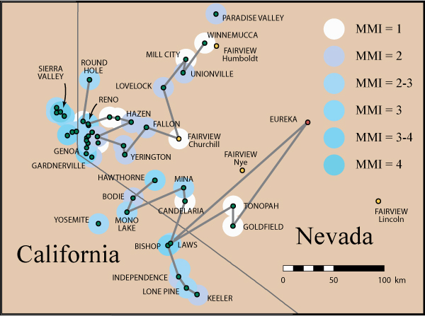
This figure shows the intensity
sites in eastern California and Nevada described in the section "East of
the Sierra Nevada." This section contains separate contributions from G.D.
Louderback and J.A. Reid. The intensity assigned to
the site is indicated by the color of the surrounding dot. The site list in the
Louderback contribution is divided into a northern
and a southern set of sites. Louderback traveled through Nevada and personally
interviewed people in towns from Reno to Winnemucca, in an attempt to determine
the eastern limit of the earthquake felt area. The ordering of the northern set
of intensity sites is indicated by the shaded line that runs from Round Hole to
Winnemucca. The four candidate locations for the Fairview site are shown as
small yellow circles with the county labeled: the location near Fairview Peak
in Churchill County is clearly the most appropriate. The ordering of the
southern set of sites is indicated by the shaded line that runs from Hawthorne to
Keeler. The reports from these sites have been obtained from correspondence
rather than personal interviews. In particular, the report from Eureka was
obtained from correspondence and cannot be corroborated: we have drawn the
shaded line for the southern set of sites through it because it is included in
Lawson’s list, but we have assigned an intensity. J.A. Reid gives felt reports
for 12 sites mostly in Washoe County, but also includes a felt report from
Paradise Valley, 20 miles north of Winnemucca.
Strategies for Locating 1906 Intensity Sites
Many of the sites where shaking
effects are reported in Lawson (1908) and other sources have since disappeared,
been renamed, or been inundated by reservoirs. While the one-time port of Alviso still exists as a backwater town, nearby Jagel Landing and Guth Landing
disappeared when the bay receded. Rural hamlets such as Peachtree, Hames, and Dove lost their Post Offices as farming evolved
and families moved away. Small towns like Elmhurst, Fitchburg, and Decoto were absorbed into larger cities and suburbs. Most
of the mines active at the turn of the century were played out and abandoned
over the next three decades. This physical and economic evolution of the
California landscape turned the problem of locating many sites into historical
puzzles.
Lawson and his co-authors depended
on personal descriptions of the earthquake shaking and effects for many sites
they were unable to visit themselves. Almost all of these descriptions came to
the California Earthquake Commission by post. When he compiled the sections on
the distribution of shaking intensity, Lawson generally used the name of the
post office to identify the site. The detailed 1896 and 1901 Post Office Maps
of California and Nevada that can be accessed on the David Rumsey
Map Collection website became a critical resource for locating the Lawson
sites.
Almost all of the Lawson'
intensity sites are shown on the 1986 or 1901 Post Office maps, with road
distances between post offices indicated. To locate "lost" post
offices such as Uvas, Altruria,
or Mulberry, we used the geographical information available in David Durham’s
comprehensive California’s Geographical Names. A number of sites (the Cantua Creek
landslide, Central San Joaquin County, and two sites with ground cracks around Covelo) were given as section, township, and range: these
sites were readily located on the modern topographic quads. The locations of
only three of the Lawson intensity sites remain uncertain: Junction City (near
San Leandro), Mountain House (near Pacheco Pass), and
Elkhorn Roadhouse (southeast of Paicines).
For areas such as Santa Rosa and
Santa Clara, where the intensity was mapped in detail, but which lie outside of
Map 21, the historical quadrangle maps posted on the Bay Area Regional Database
website were tremendously useful, particularly the 1899 Palo Alto and San Jose
quads. In addition to permitting readers to reconstruct the transits that
Lawson’s co-authors followed, these 15' quadrangle maps give a remarkable sense
of the California landscape at the turn of the century.
Links
David Rumsey
Map Collection [choose the Insight Browser, then search by keywords
"1896" or "1901"]
USGS, Bay Area Regional Database, Historicals Index