Map Showing Nevada and Eastern Sierra
Sites
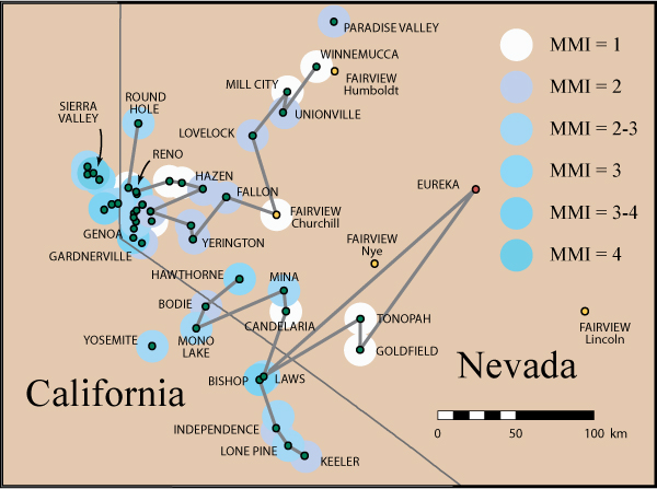
This figure shows the intensity
sites in eastern California and Nevada described in the section "East of the
Sierra Nevada." This section contains separate contributions from G.D.
Louderback and J.A. Reid. The intensity assigned to the site
is indicated by the color of the surrounding dot. The site list in the
Louderback contribution is divided into a northern and a
southern set of sites.
Louderback traveled through Nevada and personally
interviewed people in towns from Reno to Winnemucca, in an attempt to determine
the eastern limit of the earthquake felt area. The ordering of the northern set
of intensity sites is indicated by the shaded line that runs from Round Hole to
Winnemucca. The four candidate locations for the Fairview site are shown as
small yellow circles with the county labeled: the location near Fairview Peak in
Churchill County is clearly the most appropriate. The ordering of the southern
set of sites is indicated by the shaded line that runs from Hawthorne to Keeler.
The reports from these sites have been obtained from correspondence
rather than personal interviews. In particular, the report from Eureka was
obtained from correspondence and cannot be corroborated: we have drawn the
shaded line for the southern set of sites through it because it is included in
Lawson’s list, but we have assigned an intensity. J.A. Reid gives felt reports
for 12 sites mostly in Washoe County, but also includes a felt report from
Paradise Valley, 20 miles north of Winnemucca.