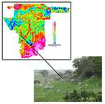
Report Cover Image: Colored apparent resistivity map at 115,000 Hz with highs
shown in warmer colors. Photograph (A.K. Clark, 2003) looking south along
Salado
Creek
at Camp
Bullis training site. The outcropping rocks compose a biostrome in the
upper Glen Rose Limestone (hydrogeologic unit D). The hill in the background
is the earthen dam across Salado Creek. The black line shows approximate
location of the biostrome on the geophysical map.
Version 1.0
|
| Posted June 2005 |
| Part or all of this report is presented in Portable Document Format. The latest version of Adobe Acrobat Reader or similar software is required to view it. If you wish to download the latest version of Acrobat Reader free of charge, click here.
|
Downloading Suggestion:
It is best to download a large PDF file to your hard drive rather than open
it inside your browser. (A standard click may automatically open the PDF file
inside the browser but doing so will result in a very slow load.)
For guidance
on how to do this, go to [http://cpg.cr.usgs.gov/toolbox/download_advice.html]. Downloading the PDF file may take several moments but will be worth the
wait. Once it is downloaded, open the PDF from your hard drive using
Adobe Acrobat—it
will open in a fraction of the time it would take to open the PDF over
the Internet.
|
