
|
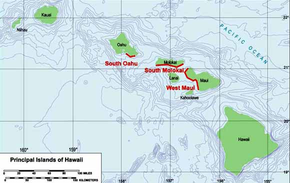
The insular shelves of the southern coasts of the islands of Oahu and Molokai, and the western coast of Maui in the Hawaiian Archipelago were surveyed using ship-towed video between June 26 and July 11, 2002, as part of USGS-CMG cruise A-2-02-HW (Figure 1.1). The goals of the survey were to collect underwater video of the sea floor to: (1) Characterize substrate type and benthic habitat distribution; and (2) Ground-truth recently-acquired data including bathymetric (SHOALS) lidar, side-scan sonar, seismic reflection, and surface texture and grain size. The underwater video also aids in the interpretation and evaluation of Hawaii's benthic habitat maps produced by NOAA and coral reef distribution monitored by the State of Hawaii (Coral Reef Assessment and Monitoring Program - CRAMP; http://cramp.wcc.hawaii.edu/). Additional metadata for this cruise is available at: http://walrus.wr.usgs.gov/infobank/a/a202hw/html/a-2-02-hw.meta.html |
Download this 59-page report as a PDF document (3 MB)
For questions about the content of this report, contact Ann Gibbs
| Help
| PDF help
| Publications main page | Open-File
Reports for 2005 |