Open-File Report 2005-1405
| About USGS / Science Topics / Maps, Products & Publications / Education / Publication: FAQ |
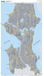
Landforms in Seattle, Washington, that were created primarily by landsliding were mapped using LIDAR-derived imagery. These landforms include landslides (primarily landslide complexes), headscarps, and denuded slopes. Over 93 percent of about 1,300 reported historical landslides are located within the LIDAR-mapped landform boundaries. The spatial densities of reported historical landslides within the LIDAR-mapped landforms provide the relative susceptibilities of the landforms to past landslide activity. Because the landforms were primarily created by prehistoric landslides, the spatial densities also provide reasonable estimates of future landslide susceptibility. The mapped landforms and susceptibilities provide useful tools for landslide hazard reduction in Seattle. |
|
|||||||||||
Part or all of this report is presented in Portable Document Format (PDF); the latest version of Adobe Acrobat Reader or similar software is required to view it. Download the latest version of Acrobat Reader, free of charge. |
||||||||||||
| AccessibilityFOIAPrivacyPolicies and Notices | |
| |
|
