 |
|
Online Only - Version 1.0
Published 2005
|
||||
| U.S. Geological Survey Open-File Report 2005-1407 Online Only - Version 1.0 Published 2005 |
By K.J. McCoy, M.H. Podwysocki, E.A. Crider, and D.J. Weary
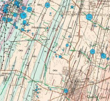
Above: Thumbnail image of a portion of the fracture trace map of Jefferson County, WV. (Data and graphics files below include the entire study area and explanation of map symbols.) |
AbstractThese data contain information on the results of single-well aquifer tests, lineament analysis, and a bedrock geologic map compilation for Jefferson County, West Virginia. Efforts have been initiated by management agencies of Jefferson County in cooperation with the U.S. Geological Survey to further the understanding of the spatial distribution of fractures in the carbonate regions and their correlation with aquifer properties. This report presents transmissivity values from 181 single-well aquifer tests and a map of fracture-traces determined from aerial photos and field investigations. Transmissivity values were compared to geologic factors possibly affecting their magnitude. Data Available in this Report
|
| AccessibilityFOIAPrivacyPolicies and Notices | |
 |
|