U.S. Geological Survey Open-File Report 2005-1428
Digital Mapping Techniques '05—Workshop Proceedings
Geological Survey of Canada,
234B-615 Booth St., Ottawa,
Canada;
Telephone: (613) 992-3562;
e-mail: brodaric@nrcan.gc.ca
In this paper we describe a web application, called Pathways-Phoenix (PX), that facilitates collaboration between scientists, planners, and the public. PX leverages open geospatial standards and technologies for information delivery, and enables users to deliberate about the information in custom designed projects. To demonstrate its re-usability and effectiveness, PX is being tested in Canada and South America by a variety of geoscience agencies.
An increasingly important task faced by geological surveys is the use of geoscience information in non-traditional societal applications such as land-use planning. This non-traditional use often requires the transformation of geoscience information into value-added products that demonstrate the socio-economic value of the underlying information. The creation, evaluation and use of such products often involves multi-disciplinary teams whose members are located in different places, but who share common tasks, plans, information sources, and various software tools. The emergence of geospatial data standards and related technologies makes it possible in theory for team members to share many of these things over the web, but in practice there is a lack of available web applications to facilitate such sharing and to promote collaboration within a team. The Pathways-Phoenix (PX) application is designed to overcome these shortcomings. It is a web application that enables information sharing and collaboration within project teams. It can be used by scientists to share scientific results and to confer about them; it can also be used by decision-makers to communicate amongst themselves and scientists, and by the public to provide feedback on implications of scientific results and on proposals by policy-makers. As such, PX represents a component of a decision-support toolbox—it is the web interface to information products and collaborative project activity.
Geological agencies are increasingly being asked to demonstrate the societal relevance of their work. Many agencies are pursuing a two-pronged strategy for accomplishing this: (1) by making their information and knowledge more widely accessible, and (2) by providing value-added products more tailored to support decision-making on societal problems.
A growing trend in information access is the move away from human-driven data access, where humans go to a web site to access data from proprietary systems, and instead toward web service access, where computers access data by communicating with web servers directly using standard protocols. This trend is reinforced in the geospatial community by the emergence of standards and technologies for accessing geospatial data through such services, and by the commitment of many significant data providers to adopt these standards. The trend signals a need to develop mechanisms for managing networks of data made available via web services. An important component of such strategies are web applications, or 'clients', that serve as human interfaces to the data networks. PX is a client intended to address the problem of managing geospatial and other data distributed over the web. It achieves this by providing an out-of-the-box solution that makes transparent many of the technologic hurdles that must be overcome, such as the installation and configuration of web mapping services and associated technologies.
Once information is available via standard protocols and access is enabled via effective clients such as PX, it becomes important to facilitate transformation of traditional geoscience data, such as geological maps, into derived products that are directly useful to decision-makers, such as risk maps (e.g. of natural hazards, groundwater contamination, etc.). Add to this the fact that the systems involved in the derivation of such value-added products are also migrating to web service interfaces, then two clear needs arise: (1) the need to manage workflows consisting of web service chains that process data into derived products, and (2) the need to develop web applications that enable scientists, decision-makers and the public not only to catalog such services and products, but also to deliberate about their fitness for use in specific societal problems. PX is designed to respond to both needs: it is developing mechanisms for managing human workflows, but not for specifying and executing computational workflows, and it provides a web-based collaboration environment that facilitates deliberation about information sources.
PX is the result of significant collaboration by initiatives from several agencies, including:
PX can trace its technologic roots, and ideological inspiration, to the Georgia Basin Digital Library (Talwar, et al., 2003) and the CordLink Digital Library (Brodaric, et al., 1999), which are its predecessors. Both of these earlier efforts explore web-based management and use of geoscience information, increasingly to augment various decision-making processes.
Standards-driven: access and manipulation of all geospatial data is via OGC web service protocols (http://www.opengis.org/). PX has mechanisms for registering, searching and retrieving geospatial data using such web services, as well as mechanisms for automatically creating web services for geospatial data stored locally by PX. PX currently supports the WMS (Web Mapping Service, for browsing images) and WFS (Web Feature Service, for retrieving and updating vector data) web service standards; support of the WCS (Web Coverage Service, for retrieving raster data) standard is planned. Visualization of data is supported via the SLD (Styled Layer Descriptor) and WMC (Web Map Context) standards, which enable users to select data subsets and assign symbolization to them. PX also manages metadata by using the Z39.50 protocol for information access, and the Canadian Geoscience Knowledge Network metadata content standards, which are a subset of the U.S. Federal Geographic Data Committee specification.
Project-driven: all data and related activities are organized in projects (called workspaces). Projects are managed by administrators, who act as gate-keepers: they decide who has access to the project and they set security levels, thereby determining what actions can be taken by individuals. Projects contain a specific subset of all resources available to PX: e.g., users can register a subset of all available data with a project, manage tasks, post news items, conduct surveys, etc.
User-driven: PX is designed to be configurable and easy to install. PX enables users to design custom user interfaces, such that the look and functionality of PX can differ from one installation to the next, and indeed from one project to the next. Such customization can be accomplished in its basic form without additional programming. Once custom styles are in place, they can be selected from a pull-down menu, resulting in a different screen appearance and potentially different functionality; users can also toggle between the English, French and Spanish languages at any time. Installation is also being designed to insulate users from the complexity of managing web services. The overall notion behind PX is re-usability: it is designed to be a plug-and-play web mapping and collaboration environment that facilitates decision support with geoscience information.
Information management functions: PX enables three types of information to be registered, deleted, somewhat updated and queried within specific folders in a project. These information types include: (1) geospatial layers (such as WMS, WFS, ESRI Shape and raster layers, e.g., a layer containing polygons classified as 'geological units'), (2) combinations of layers called maps, and (3) other documents (such as text documents, spread sheets, databases, etc.). Information can be located remotely, on some distant server, or it can be uploaded to a PX server. Once maps are created from geospatial layers they can be viewed from other systems that support OGC access protocols, such as various GIS systems.
Collaboration functions: PX enables different-time, different-place collaboration. This assumes that users are not co-located (i.e., different-place), and that they do not attempt to create or edit the same resource simultaneously (i.e., different-time). PX enables users to add, edit, delete, and organize a variety of collaboration resources in folders within a project, including: announcements, contacts (e.g., project members), a discussion forum, an email archive, a list of events, a catalog of web links, polls (questions with multiple-choice answers), surveys (questions with free text answers), tasks, weblogs, news feeds, and publication mechanism that allow information to be broadcast outside the project. The intent of the collaboration functions is to enhance communication and interaction amongst project participants.
Project administration functions: these functions enable projects to be created and managed, including (1) configuring a project by changing its visual appearance or by selecting which information and collaboration functions will be made available to project members; (2) adding and deleting project members, and editing their profiles including security levels for accessing and publishing information; and (3) managing project content, including the recycle bin, which enables recovery of deleted items, and project statistics, which summarize project activity.
These three groups of functions are typically made visually available as selections in the user interface, i.e., note in Figure 1 that the column on the left contains links to the information, collaboration, and administration functions.
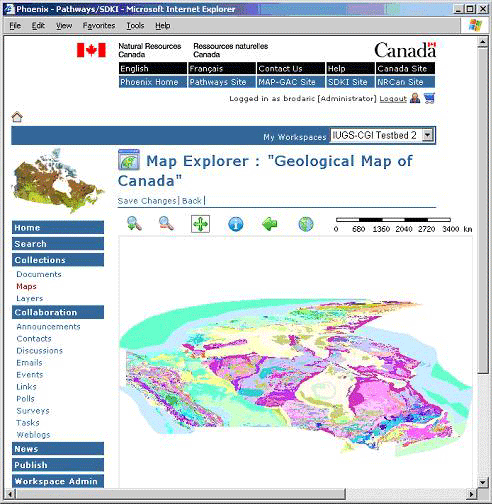
Figure 1. PX's map viewer: note the information, collaboration and administration functions on the left (www.pathways.geosemantica.net).
PX is designed using a three-tiered system architecture, including tiers for: (1) content, (2) business functions, and (3) presentation. The PX user interface components, including customized user content in the form of graphics and text, as well as project contents (e.g., maps) that are displayed and managed by that interface, are all stored in a SQL-Server relational database. Access to the PX elements in the database is enabled by software middleware consisting of functions written in the Microsoft ASP.NET environment. These functions are then used by style sheets in the presentation tier, which expose the functionality to the user via the customizable user interface. Installation of PX on a server requires the SQL-Server relational database to be pre-loaded, and the open-source MapServer software is then semi-automatically loaded during installation. Once a PX server is in place, projects can be easily established. PX is a very thin client—users only require a web browser with the Flash plug-in to be able to work with PX projects.
At the time of this paper, PX is being used mainly by two GSC projects: (1) in the Pathways Project, PX is deployed to increase use of geoscience information in land-use planning, and (2) in the South American-based Multi-Andean Project it is geared toward the management and sharing of natural hazards information amongst six geological survey organizations.
The Pathways project is responding to the perception that regional planners are not often using geoscience information in the development of growth strategies and plans, or are not using it as effectively as they might. To overcome this situation, the Pathways has adopted a risk-based approach in which consecutive modeling steps ultimately lead to the generation of alternative land-use scenarios, with attached socio-economic risk levels, that can be considered by planners. PX is being tested in two ways under this approach: (1) as a means of enabling collaboration amongst a team of water scientists jointly developing hydrogeological models in the Okanagan Basin, and (2) as a means of distributing geospatial information, including model results, to decision-makers, and encouraging web-based deliberation over those results. Figure 2 shows the PX home page for this project, which can be accessed via pathways.geosemantica.net.
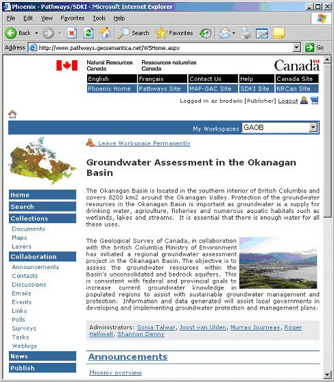
Figure 2. PX home page of the Groundwater Assessment in the Okanagan Basin project.
The Multi-Andean Project aims to decrease the negative impact of natural hazards on communities in six countries (Argentina, Bolivia, Colombia, Chile, Ecuador, Peru, Venezuela) in the South American Andes region. An important component of the work involves the development of an information system, called GeoSemantica, that enables the various agencies to deliver, manage, and share information over the web, including information from joint project work. GeoSemantica is composed of PX installations, called nodes, that are customized for use within individual countries. At this time there exist nodes in Chile, Colombia and Canada, with more to follow soon. These nodes are being heavily used, so much so that they are being adopted in non-geoscience domains by other government agencies and universities. Figure 3 shows the home page for the Canadian node, which can be accessed via http://can.geosemantica.net/—note the customized graphical user interface and its contrast to the user interface adopted by the Canadian Pathways Project, which shown in Figure 2.
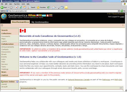
Figure 3. Home page of the Canadian GeoSemantica node.
Pathways-Phoenix (PX) is a web application designed to enable (1) management of geospatial information provided via open geospatial standards and technologies, and (2) deliberation over such information between scientists, policy-makers, and the public to aid in decision support. It is designed to be easily installed on a web server, and can be used in any web browser that has installed the Flash plug-in. PX development is on-going, with v1.0 expected to be released over the web to the public, at no cost, in March 2006. It is currently being tested in Canada and South America in various geoscience projects that require collaboration amongst individuals from various disciplines and jurisdictions. Additional capabilities to be added to PX in the near future include:
Talwar, S., Journeay, M., Harrap, R., Brodaric, B., van Ulden, J., Grant, R., and Denny, S., 2003, The Georgia Basin Digital Library Project: a framework for a place-based exploration of sustainability issues: Geomatica, v.57, no.2, p. 155-164.
Brodaric, B., Journeay, M., and Talwar, S., 1999, Using the Proposed U.S. National Digital Geologic Map Data Model as the Basis for a Web-Based Geoscience Library Prototype, in D.R. Soller, ed., Digital Mapping Techniques '99—Workshop Proceedings: U.S. Geological Survey Open File Report 99-386, p.83-91, available at http://pubs.usgs.gov/of/1999/of99-386/brodaric1.html.

![]() U.S. Department of the Interior |
U.S. Geological Survey
U.S. Department of the Interior |
U.S. Geological Survey
URL: pubsdata.usgs.gov /pubs/of/2005/1428/brodaric/index.html
Page Contact Information: David R. Soller
Page Last Modified: Saturday, 12-Jan-2013 22:05:40 EST
