U.S. Geological Survey Open-File Report 2005-1428
Digital Mapping Techniques '05—Workshop Proceedings
1U.S. Geological Survey,
Florida Integrated Science Center,
600 4th Street South,
St. Petersburg, FL 33701
Telephone: (727) 803-8747 x3029;
Fax: (727) 803-2032;
e-mail: sdadisman@usgs.gov
2U.S. Geological Survey, e-mail: jflocks@usgs.gov
3Computer Sciences Corporation, e-mail: kcalderon@usgs.gov
The Louisiana Sedimentary and Environmental Database (LASED) is the result of combined efforts of the U.S. Geological Survey (USGS) and State and academic cooperators to manage decades of geologic data gathered from the Louisiana coastal zone. The database incorporates a wide range of data types: sediment-sample descriptions and analyses, geophysical profiles, raster-image basemaps, logbooks, etc. The data is integrated with spatial and attribute information to provide processing and visualization capabilities using standard Geographic Information System (GIS) and Internet-browsing tools. The data types are linked so that complex queries and analyses can be performed across datasets. Decades-old to recently acquired analog data are included through the use of new technology and processing techniques. The integrated geodatabase is quickly and easily expanded and serves as a digital archive of almost any type of data. The development of the geodatabase is in response to a growing need for the USGS and collaborators to efficiently access coastal geologic data for shoreline management issues. Full access to LASED data is available to registered users via the Intranet, and public access to view map products and data is available over the Internet.
The coastal region of Louisiana is currently under stress; human impact and natural processes have resulted in severe erosion of the shoreline. Wetland deterioration and land-loss rates due to subsidence, manmade alteration, and tropical storms exceed those found elsewhere in the Gulf of Mexico (Morton and others, 2004). A management plan is needed for long-term shoreline protection of the Louisiana coastline (Louisiana Coastal Wetlands Conservation and Restoration Task Force and the Wetlands Conservation and Restoration Authority, 1998). This plan must be based on a scientific understanding of the geologic history and processes involved in shoreline change, which includes an efficient and comprehensive use of all available scientific information.
The river deltas and barrier-island shorelines that protect wetlands and developed regions of Louisiana are the result of a complex series of fluvial and marine depositional events that have occurred over the past 4,000 years (Frazier, 1967). Identifying the stratigraphic framework of these past events is important to define the regions coastal evolution and to locate adequate resources for coastal management. In response to these needs, the USGS, in cooperation with the Louisiana Geological Survey, Louisiana Department of Natural Resources (LDNR), and University of New Orleans, is actively collecting scientific information associated with near-surface (upper 100 meters) geology and geomorphology of the coastal zone. This information is integrated with geospatial data to produce a geodatabase that includes various forms of georeferenced basemaps, such as digital elevation models (DEMs) and satellite imagery (Figure 1). The geodatabase contains geographic positions and links to attribute information for sediment cores, seismic-reflection profiles, sidescan sonar mosaics, bathymetry, and numerous basemap features. The geodatabase system is dynamic and flexible; a wide variety of data is included on an ongoing basis from both historical and recent sources. The system is highly interactive in that it allows for cross-referencing of different types of data as well as links to displays of the data. LASED is inclusive of the Louisiana coastal zone and a component of a much larger geodatabase system developed by the USGS Florida Integrated Science (FISC), St. Petersburg. Database management and data visualization are actively maintained to keep pace with developing technology. The geodatabase also serves as the infrastructure for a permanent online digital data-archive system and it controls access to all associated information, such as logbooks, photographs, analyses, and publications (Figure 2).
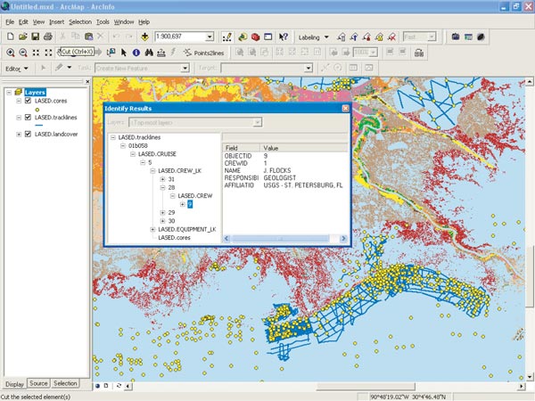
Figure 1. Display of LASED geodatabase using ArcMap. Data layers include seismic-reflection profile locations (lines) and sediment-core sites (dots) along the Louisiana coastal zone. Raster basemap feature is landcover produced by the Louisiana Gap Analysis Project of the USGS Biological Research Divisions National Wetlands Research Center (NWRC) and based partly on Thematic Mapper (TM) satellite imagery. Inset shows an example of the linked crew attribute table information.
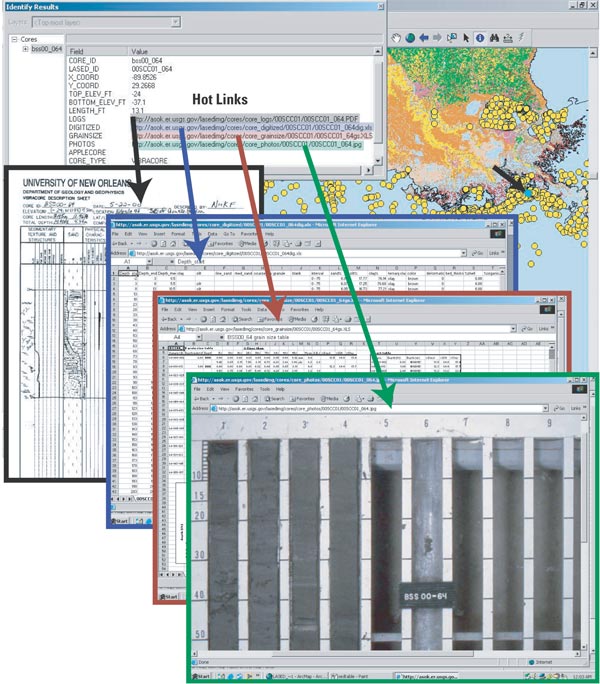
Figure 2. Example of sample information stored in the LASED geodatabase and hot linked to website locations (overlaid boxes) for associated sample data. Hot linked data are (from left to right) scanned core description log, digitized core log, grain size analysis results, and digital core photograph. Together, this information forms a permanent online digital archive of these data. Small arrow on map points to core location.
Although most data currently collected by scientists are in digital format, there is a large repository of information and literature that exists in paper archives. Conversion of this information into standard digital formats accessible by computer applications is often difficult and results in loss or degradation of data. A system developed at the St. Petersburg Office converts traditional paper sediment-core description sheets into digital spreadsheets that capture all of the symbols, text, and quantitative attributes of the sample (Flocks, 2004). Because scientific data are commonly collected in a repetitious, concise matter (i.e., forms, tables, graphs, etc.), these data can be recovered digitally using a translation process that relates the position of an attribute in defined two-dimensional space to the value that the attribute represents (Figure 3). The relations between position and data value is dependent on a key table that is customized to the type and format of data being converted. This system allows the incorporation of a vast amount of previously non-digital scientific data into the geodatabase.
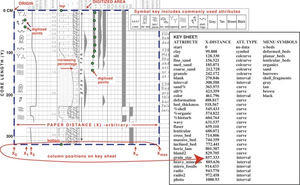
Figure 3. System to convert sediment core information from form-style description sheets into quantitative spreadsheet format: description type (e.g., percent sand) is categorized by the style of data (symbol, curve, etc.). This style determines which subroutine is used to convert the digitized data based on a key sheet annotated by column position. Abundance or presence of attribute is calculated by converting a digitized point to a magnitude value within the column. For more detail refer to Flocks (2004).
Recent advances in technology, like large format scanners and image processing software, now allow shared access through LASED to decades-old legacy datasets. Digital scans of thousands of feet of analog seismic-reflection profiles and new image-processing software permit conversion of the resulting digital images into industry-standard format for further processing and enhancement. Additional software converts the processed data into an interactive seismic-reflection profile webpage that allows the viewer to find a geographic location and depth for a cursor position on the interactive profile using a web browser (Figure 4). These new tools provide improved visualization and use of these legacy datasets, and LASED serves as the "search engine" for locating these data spatially or by attribute.
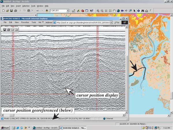
Figure 4. Display of an interactive seismic-reflection profile webpage (produced by Chesapeake Technology Inc., SonarWeb software) with ArcGIS. Seismic-profiles (double gray lines) are displayed atop the NWRCs landcover basemap. Selected seismic-profile line (bold black) is displayed in a web browser inset. Position of cursor on profile image is tracked with geographic coordinates (latitude/longitude and Universal Transverse Mercator (UTM)) and depth (meters and milliseconds) in status bar at base of browser window.
Finally, the development of standardized logs, acquisition parameters, and naming conventions has enabled rapid processing of newly acquired digital data. Use of standardized methods and formats makes population of the geodatabase and associated published data archives routine. The rapid population of the geodatabase provides instant feedback to project planners. For example, a comprehensive display of all available data shows a roadmap of where data are lacking. Since all data stored or linked to the geodatabase are in digital format, distribution of the data can be accomplished electronically. The geodatabase is a powerful analysis tool. Using standard ArcGIS software, complex multivariate statistical analysis can be applied to produce new datasets and customized map products.
Two Oracle 9i databases managed by Environmental Systems Research Institutes (ESRI) ArcSDE (Spatial Database Engine) 9.0 server software form the core of the FISC-St. Petersburg geodatabase system. The databases reside on a Sun Enterprise E250 running Solaris 8 with a directly-attached Sun D2 Array. Detailed summaries of the computing platform and disk architecture are shown in Table 1. The other main components of the geodatabase system are an Apache web server and an ArcIMS (Internet Map Server) (Figure 5).
| Geodatabase Server Platform | |
| Hardware: | Sun Enterprise E250 with a directly attached Sun D2 Array |
| Operating System: | Solaris 8 |
| Memory: | 2 GB RAM |
| CPU Speed: | 2 x 300 MHz UltraSparc-II |
| Disk Space: | 378 GB raw disk capacity |
| Server Disk Management | |
| Management Software: | Solaris Disk Suite v4.2.1 |
| Operating System: | Mirrored on 2 x 9 GB disks |
| Oracle & ArcSDE software: | Mirrored on 2 x 36 GB disks |
| Oracle Data: | RAID 5 system on 5 x 36 GB disks, with 1 hot spare 36 GB disk |
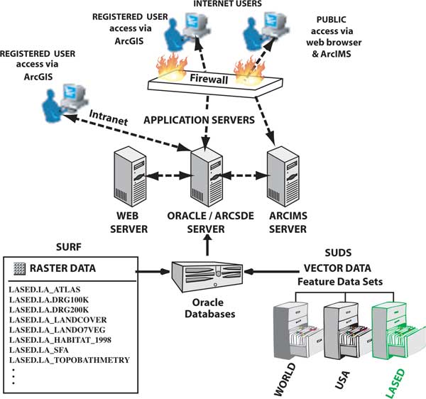
Figure 5. Schematic of the USGS FISC-St. Petersburg geodatabase system showing the relationships between the users, applications servers, databases, and the LASED raster and vector components.
ArcSDE management of the Oracle databases is similar to a personal or "unshared" geodatabase in that there is straightforward access by means of standard ArcGIS desktop software. However, ArcSDE management offers several advantages including multi-user editing, versioning, raster storage, and an unlimited database size (Environmental Systems Research Institute, 2002).
The St. Petersburg Office has two geodatabase instances so that different data types can be stored optimally; they are the Spatially United Data Sets (SUDS) and the Spatially United Raster Features (SURF). SUDS stores exclusively vector data (survey tracklines, laboratory analyses, etc.) whereas SURF stores raster data (remote sensing imagery, elevation maps, etc.). Vector and raster data are divided into two separate databases for organization, speed, tuning, and to facilitate backups. Oracle database software was chosen because it is compatible with ArcSDE software and the FISC-St. Petersburg Solaris/Linux computing environment, is easily expanded, and is reasonably priced through government contracts. ArcSDE software was selected because it is the standard USGS geodatabase solution and is widely deployed.
Within the St. Petersburg geodatabase system, LASED encompasses a schema made up of a feature dataset, tables, relationship classes, and raster datasets that together store, organize, link, and serve Louisiana coastal data to USGS scientists and collaborators (Figure 5). LASED data is incorporated within both Oracle databases (SUDS/vector and SURF/raster). Within SUDS, the LASED feature dataset currently consists of 29 feature classes and 4 relationship classes. Locating data into one feature dataset facilitates data organization and read-and-write permissions. There are also 7 LASED tables and 4 LASED relationship classes outside of the feature dataset (Figure 6). In addition, there are 70 Louisiana basemap feature classes within SUDS to which LASED users have access. Within SURF, naming conventions are used to organize approximately 40 LASED raster datasets, and read-and-write permissions are managed individually for each layer. All SUDS and SURF layers have Federal Geographic Data Committee (FGDC) compliant metadata.
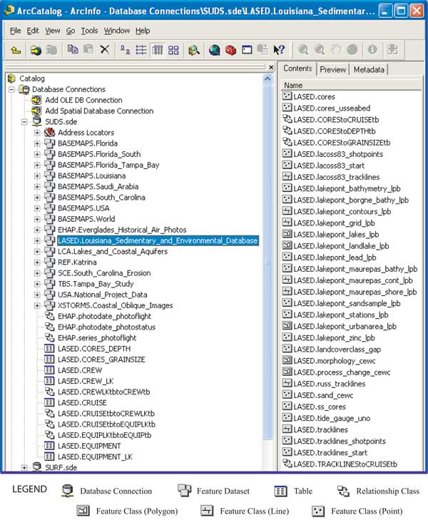
Figure 6. ArcCatalog display of the hierarchical structure of LASED data in the SUDS vector geodatabase. Icons are defined in legend.
The LASED schema is based on ESRIs Marine Data Model, or ArcMarine (Wright and others, in press), which attempts to spatially integrate the many data types that are unique to the marine realm (Figure 7), and considers how coastal and marine scientific data can be more effectively integrated into 3-D space and time series. Currently, LASED contains a wide variety of data including bathymetry, sediment-core data, seafloor-change images, seismic- reflection tracklines, and sidescan-sonar mosaics. Building on an established data model like ArcMarine has two major advantages: 1) for the GIS user, the model provides a template for the geodatabase structure that promotes networking and data sharing through established standards, formats, and relationships; and 2) for the developer, the model provides a basic framework for writing program code that can be used by a wider audience (ArcMarine Working Group, written comm. 2005, Figure 7). As more users build on this data model, additional tools to analyze or visualize these unique data types should evolve.
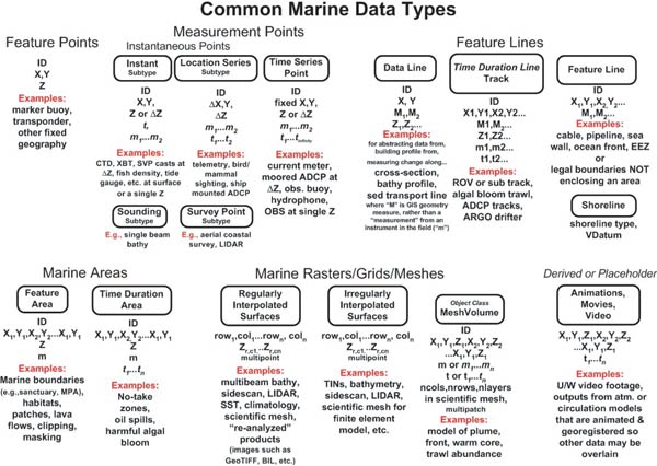
Figure 7. Diagram of common marine data types included in the Marine Data Model (from Wright and others, in press). Figure shows examples of common types of marine data and the relationships they share with geospatial information and features. For detailed explanation refer to http://dusk2.geo.orst.edu/djl/arcgis/index.html.http://dusk2.geo.orst.edu/djl/arcgis/index.html
The FISC-St. Petersburg geodatabases exist on an internal network protected by commercial firewall products. Direct access to the geodatabases through standard ArcGIS products, such as ArcCatalog and ArcMap, is allowed only to registered users. All accounts are password protected, and permission to load data into the geodatabases is limited to privileged users. LASED data and products can also be viewed over the Internet via an ArcIMS located at http://coastal.er.usgs.gov/lased/.
The St. Petersburg geodatabase backup plan consists of running both databases in ARCHIVELOG mode and using Oracles Recovery Manager (RMAN) utility to do monthly full backups and daily incremental backups. The backups are copied to tapes which are then rotated offsite. RMAN has many advantages over user-managed backups that use operating system utilities: for example, the ability to perform incremental backups, a simplified procedure for backing up an open database, corrupt block detection, automated backups, backup catalogs (metadata), backup validation, automated management of backup files, and automated recovery (Oracle, 2005). The St. Petersburg Office also maintains on a second server duplicate development databases that can quickly be pressed into service to ensure minimal user interruption should the production databases require downtime for any reason. The development databases are also used for testing purposes.
The disk management system is shown in Table 1. The UNIX operating system, Oracle software, and ArcSDE software are mirrored on separate drives. If a disk failure occurs, the mirrored drive will take its place with no downtime. The data is stored in a RAID5 configuration with one hot swap disk. If one disk fails, a new disk can be brought online and the RAID5 system will repopulate the new disk automatically.
LASED is more than just a geodatabase; it also forms the backbone of a permanent online digital data-archive system. Seamless interaction between published data archives (e.g., Calderon and others, 2003) and the geodatabase allows for rapid dispersion of data to collaborators. The system takes full advantage of ArcGIS information tools and a web server. The data files are linked either spatially or by attribute and provide to the remote user digital representations of almost any combination of data. Data types, such as sediment-core analyses, descriptions, and photographs, are dynamically linked to cruise information, equipment information, scanned field logbooks, processed and analog seismic-reflection profiles, and related publications and websites. As an example, the linked tables allow any user with standard ArcGIS tools and a web browser to identify on a map where a core was taken, see a digital image of the original core log, view a core photograph (Figure 2), query grain-size analyses (Figure 8), and find out when the core was taken, by whom, and where it is stored. LASED currently holds data for 20 cruises that include 750 seismic-reflection profiles covering about 6,500 kilometers (4,000 miles) and 1,150 cores.
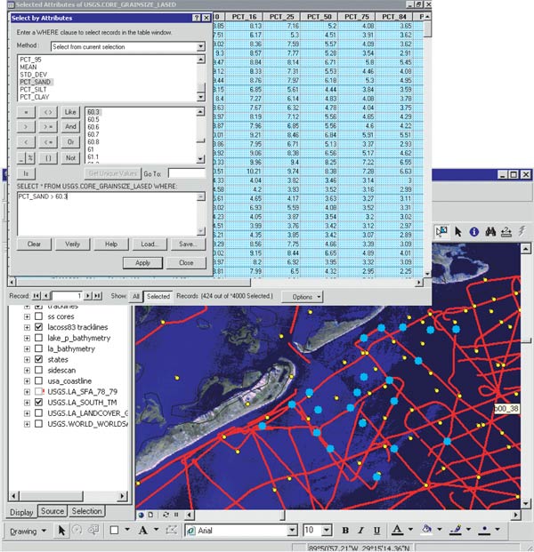
Figure 8. Example of a data query of sediment-core grain-size analyses with greater than 60 percent sand. Background map shows query results highlighted as large dots. Raster basemap features LANDSAT Thematic Mapper (TM) satellite imagery.
A wealth of geologic data exists for the Louisiana coastal zone. There is a critical need for a long-term data management plan that provides data access for researchers and planners who are combating wetland loss and shoreline change. The USGS and Louisiana State cooperators have joined forces to address this need and have launched an aggressive effort to assemble all existing geologic and geomorphic data from the Louisiana coastal zone.
A substantial repository of information and literature exists in paper archives. Systems developed at the St. Petersburg Office convert traditional paper descriptions, logs, and profiles into digital format and allow the distribution of a vast amount of previously non-digital scientific data. New technology and software permit processing and computer-assisted visualization of data in ways that allow direct spatial interaction with the information. Finally, the use of standardized logs, acquisition parameters, and naming conventions permits rapid processing of newly acquired digital data and prompt distribution to researchers and project planners.
The St. Petersburg Office has organized the stockpile of data and all associated metadata into a comprehensive geodatabase system. LASED is a component of the St. Petersburg geodatabase system and is geographically focused on the Louisiana coastal zone. Two Oracle databases form the core of the geodatabase system and are managed by ArcSDE software. Advantages for managing the data with ArcSDE include multi-user editing, versioning, raster storage, and an unlimited database size. The other main components of the geodatabase system are a web server and an Internet Map Server. The geodatabase is highly interactive in that it allows the display of a wide variety of data that can be cross-referenced by geographic position or attribute. Direct access to the geodatabases is allowed only to registered users via the Intranet and permission to read or load data into the geodatabases is limited to certain users. Access to LASED data is also available over the Internet via an ArcIMS.
LASED is based on ESRIs Marine Data Model, or ArcMarine, which attempts to spatially integrate the many data types that are unique to the marine realm. Currently, LASED contains a wide variety of data including bathymetry, sediment-core data, seafloor change images, seismic-reflection tracklines, and sidescan-sonar mosaics. LASED also forms the backbone of a permanent online digital data-archive system that currently holds information for 20 research cruises.
The Coastal and Marine Geology Program of the USGS, the U.S. Army Corps of Engineers, the University of New Orleans, and the LDNR provided funding and/or support for this project. We thank Jack Kindinger for his support and guidance and Heather Mounts for implementing SUDS and SURF and the prototype of LASED. This document was improved by the reviews of Robert Wertz and Barbara Poore of the USGS in St. Petersburg, Florida.
Calderon, K., Dadisman, S.V., Kindinger, J.L., Perry, G.M., Flocks, J.G., Wiese, D.S., Kulp, M., Penland, S., Britsch, L.D., and Brooks, G.R., 2003, Archive of boomer seismic-reflection data collected during USGS cruises 00SCC02 and 00SCC04, Barataria Basin, Louisiana, May 12-31 and June 17-July 2, 2000: U.S. Geological Survey Open-File Report 03-402, DVD (1 disc), available at http://pubs.usgs.gov/of/2003/of03-402/.
Environmental System Research Institute (ESRI), 2002, Working with the Geodatabase: Powerful multiuser editing and sophisticated data integrity: ESRI white paper, 9 p. available at http://www.esri.com/library/whitepapers/pdfs/arcgis_geodb_multiuser.pdf.
Flocks, J., 2004, Converting analog interpretive data to digital formats for use in database and GIS applications: U.S. Geological Survey, Open-File Report, 2004-1070, 21 p.
Frazier, D., 1967, Recent deltaic deposits of the Mississippi River: Their development and chronology: Gulf Coast Association of Geological Societies, Transactions, v. 17, p. 287-315.
Louisiana Coastal Wetlands Conservation and Restoration Task Force and the Wetlands Conservation and Restoration Authority, 1998, Coast 2050: Toward a Sustainable Coastal Louisiana: Baton Rouge, La., Louisiana Department of Natural Resources, 161 p., available at http://www.coast2050.gov/2050reports.htm.
Morton, R., Miller, T., and More, L., 2004, National assessment of shoreline change: Part 1 Historical shoreline changes and associated coastal land loss along the U.S. Gulf of Mexico: U.S. Geological Survey Open-File Report 2004-1043, 42 p.
Oracle, 2005, Oracle 9i backup and recovery concepts: Oracle software manual, available at http://www.stanford.edu/dept/itss/docs/oracle/9i/server.920/a96519/toc.htm.
Wright, D.J., Halpin, P.N., Blongewicz, M.J., and Breman, J.B., in press, ArcMarine: GIS for a Blue Planet: Redlands, California, ESRI Press, http://dusk2.geo.orst.edu/djl/arcgis/index.html.
ApacheApache HTTP Server project, http://httpd.apache.org/.
ArcGIS, ArcIMS, ArcMap, ArcCatalog, ArcSDEEnvironmental Systems Research Institute (ESRI), Inc., 380 New York St., Redlands, CA, 92373-8100 USA, (909) 793-2853, http://www.esri.com/.
ArcMarineArcMarine: The ArcGIS Marine Data Model, http://dusk2.geo.orst.edu/djl/arcgis/index.html.
OracleOracle Corp., 500 Oracle Parkway, Redwood City, CA 94065 USA, (800) ORACLE-1, http://www.oracle.com/.
SonarWebChesapeake Technology Inc. Chesapeake Technology, Inc. (CTI), 1146 Kathy Way, Mountain View, CA 94040, USA, (650) 967-2045, http://www.chesapeaketech.com/.

![]() U.S. Department of the Interior |
U.S. Geological Survey
U.S. Department of the Interior |
U.S. Geological Survey
URL: pubsdata.usgs.gov /pubs/of/2005/1428/dadisman/index.html
Page Contact Information: David R. Soller
Page Last Modified: Saturday, 12-Jan-2013 22:05:52 EST
