U.S. Geological Survey Open-File Report 2005-1428
Digital Mapping Techniques '05—Workshop Proceedings
In 1997, at the first Digital Mapping Techniques workshop, in Lawrence, Kansas, the Idaho Geological Survey (IGS) described their map production techniques. Since then, the IGS has published about one hundred geologic maps. This report will update how those maps, and the data behind the maps, are produced, published, and delivered online.
The Idaho Geological Survey is housed on the University of Idaho campus in Moscow, 300 miles from the capital, Boise. There currently are 10 full-time state-funded staff, half of whom are geologists. Geologic mapping is the IGS's largest mission. The IGS has published nearly 400 geologic maps, many of which are page-sized figures in bulletins or pamphlets as part of mining reports. The IGS in 1989 began operating a full-time map production facility, which from the start was a "digital" shop that used inexpensive Computer Aided Design (CAD) software. In 1992, IGS began to use AutoCAD software to capture geologic map data in a GIS-compatible format. In 1992 the IGS published its first full color, press-run geologic map using digital processes to make map separates. Our methods of publication have changed dramatically in the last ten years (see Figures 1 and 2). At the time of our first DMT presentation, in 1997, most maps were published in black-and-white, Xerographically. To publish a map in color before 1998 required a printing press. Then and now, there was little money in the budget for expensive press runs. Beginning in 1998, all maps published by the IGS were produced in color using methods discussed in this paper. Maps were design to be printed-on-demand using ink-jet, large-format print technology. Beginning in 2001, all newly published maps became available online free as Acrobat Reader files (PDF format).
 |
 |
|
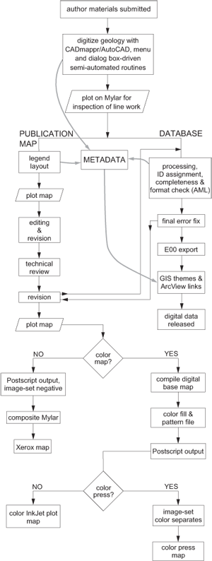
Figure 1. Chart showing map production workflow in 1997. |
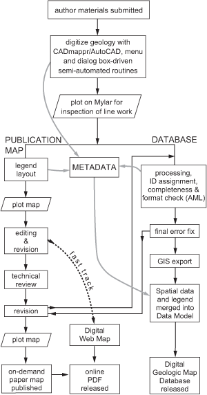
Figure 2. Chart showing map production workflow today. |
Over the past 10 years the IGS Digital Mapping Lab has prepared more than 100 geologic maps for publication, which is more than one-fourth of all maps produced since establishment of the Idaho Geological Survey (Figure 3). Currently the Digital Mapping Lab has two full-time and two part-time employees. It is responsible for producing published maps, managing all data generated from mapping projects, producing digital geologic map databases, managing the local network and file server, and maintaining the IGS web site.
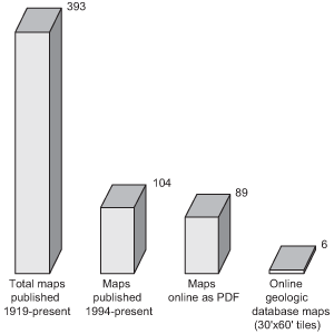
Figure 3. Chart showing geologic map publication statistics for the Idaho Geological Survey.
The staff at the Idaho Geological Survey find it more productive and efficient for the geologists to do the science and the cartographers to make the maps. The geologists do all the fieldwork and draw lines on Mylar overlays or on greenlines and prepare all other relevant materials. The IGS's Digital Mapping Lab takes these materials and captures the data for publication as a geologic map and as a database.
Geologic data capture is done in AutoCAD r 14 with CADmappr, an AutoCAD plug-in developed in-house. Data is digitized or captured in real coordinates, specifically Idaho state plane feet. This "real units" map is the database version of the map in which all geologic objects are captured, geologically attributed, and given a source identifier. All subsequent changes are made to the database map, which is ultimately released as part of a GIS data set (see Figure 2). Digitizing is usually done on large digitizing tablets with programmable 16-button cursors. To begin the process, the map is aligned on the digitizing tablet. The mapping to be captured is either on a stable base with a Mylar overlay registered to it, or on a greenline. The map is taped to the digitizing table, then the corner tics of the map are aligned to the on-screen tics. The on screen tics for a 7.5-minute quadrangle are placed at 2.5-minute intervals for the latitude and longitude extent of the map. Once the map is aligned with sufficiently low error (RMS 10 or less), we begin by digitizing the geologic contacts.
Once a contact is digitized, a dialog box pops up with the list of units, line types, and whether its a contact, fault, or hidden contact. After picking the units that lie on either side of the line, the screen returns to the map and the topology is chosen for the two units by pointing to the correct contact side for each segment. Map unit topology is stored with each contact (AutoCAD extended entity data) and also in the layer-naming format for each contact. To make PostScript polygon fill files, all similar map unit layers are combined automatically. For example, all "Qal" polygons can be shown by turning on all layers with "Qal" in their name. GIS polygons are only generated after exporting a specialized ArcInfo interchange file (E00) from AutoCAD to ArcGIS using routines that combine layers as above with a centroid label for each polygon. This process is repeated until all contacts and faults are captured. Contacts and faults that also serve as geologic contacts are digitized first, then "dangling" fault lines are added. Each contact segment is digitized once. If the contact happens to be a fault, it is still only digitized once. Separate geologic layers or themes (e.g., all faults) can easily be generated at any time by running a query or simply turning AutoCAD layers on or off using custom tools.
Next, bedding attitude and other symbols are digitized. Again, a series of custom tools along with the programmed 16-button cursor make this task relatively simple and efficient. Finally, text labels for units and objects (e.g., fault names) are added to the map database.
When digitizing is complete a check plot is made. Check plots are done on the lab's beloved 15-year-old HP pen plotter to make sure everything that should be on the map is indeed on the map and spatially correct. Lab staff checks the plot against the geologist's line work and makes any corrections. Geologists are encouraged to also use this check plot to find errors. Geologic source attributes are then added to all geologic objects on the map (Table 1). Next, a series of quality control checks verify the maps completeness. A series of manual checks and software routines check for polygon closure, fault type and movement direction, and topology of contacts. Polygon topology need not be checked, because if all contacts are correct then polygons have to be correct. Polygons are only generated outside of the AutoCAD drawing for two purposes; the first is when PostScript color file files are generated for FreeHand or Illustrator, and the second is to check for missing unit labels in ArcGIS. The map is then ready to save as the "pub" version.
| Geologic Object Attribute | Description |
|---|---|
| Line type | Certainty and relationship |
| Unit to Left and Right of line | Topology |
| Fault type | Normal, thrust, etc. |
| Movement | Direction of fault movement relative to first vertex |
| Source | Geologic reference |
| Map code | Quadrangle or map name |
| Tile code | 30' x 60' minute tile name |
| Object name | Fault name or contact name |
To expedite map layout in FreeHand or Illustrator, the CadMappr plug-in includes an entire module for exporting PostScript files from AutoCAD. First, the pub version is made by reducing the database map to the appropriate publication scale using a custom tool. Once at publication scale the map is ready for final steps before export. Color and pattern selection for each map unit is the most time intensive of these steps. A lookup table holds the values for color and pattern type. This table is used to generate color fills and patterns when the AutoCAD unit polygons are exported as PostScript files. Another lookup table is used to control line weights and the PostScript output order for line and symbol objects when they are exported. In PostScript, one map object, then the next object, and so on, are written to the print file; if two objects occupy the same map area, the object written to the file first will be physically covered by the object written later. If it is desired that a red symbol be shown under black geologic contacts, the PostScript coding for the symbol must be written before the contact information. In this way, PostScript files for various layers of geology are generated for layout (Figure 4).
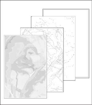
Figure 4. EPS/PS layers from AutoCAD, for layout in FreeHand or Illustrator. From front to back, the layers are: color fill, geologic contacts, geologic symbols, and alignment boxes.
AutoCAD and CADmappr allows the Idaho Geological Survey's Digital Mapping Lab to be productive while attributing each geologic object (Table 1). These geologic attributes are designed for export to ArcInfo and ArcGIS. For example, the movement direction for faults is stored while digitizing. This attribute follows ArcInfo rules for right-left side relative to the beginning node or first vertex. Separate geologic layers are easily created for export by running a query.
Either FreeHand or Adobe Illustrator can be used for the final geologic map layout. PostScript (PS) files can be imported directly into Illustrator. Before import into FreeHand, the PostScript layers are processed by a conversion program called Transverter Pro and turned into EPS files; EPS files work better in FreeHand, whereas PS files work better in AI. Once the PostScript files from AutoCAD are imported (or placed), the layout procedures described below are essentially the same for either FreeHand or Illustrator.
The first step in map layout is to open a neat line template. This template also contains various "boilerplate" information including cartographic and author credits, scale, declination, and title blocks, which can be modified. Then, the PostScript layers generated in AutoCAD are imported and aligned to a specially created alignment layer in FreeHand (the "backmost" layer in Figure 4). Next, the scanned image of the stable film base map is rectified and imported where it is also aligned. In Illustrator, all layers are brought in and aligned to the base map visually, and patterns are added manually from the USGS pattern set (U.S. Geological Survey, 1999). Once all map layers are imported and aligned, all other parts of the map are imported and manipulated to create an aesthetically pleasing map. These remaining parts include cross-sections and correlation charts which are created in AutoCAD using the same procedures as for the geologic map. If the map sheet includes tables, these are imported from Microsoft Excel and formatted to a template. Text is imported from WordPerfect and formatted to a standard style. If a booklet is required, it is laid out in FreeHand.
Once laid out, the completed map is printed in color on an ink-jet printer. The authors check this first plot, and corrections are made accordingly. Necessary corrections to the geology are made in the database version of the map and are exported again. At this point the map author decides whether the map is either "fast-tracked" (IGS Open-File) and published online as a Digital Web Map, or sent on for technical (scientific) review. Finally, after technical review and review by the IGS publications editor, the map is edited as necessary and prepared for publication in one of the IGS's map series (Table 2). All geologic map data captured is eventually compiled, with other mapping, into a 30' x 60' tile and released as a geologic map database.
| Publication Series | Description | Online free (pubs since 1998) |
Paper Print Available | Average Time to Publish |
|---|---|---|---|---|
| Geologic Map | External technical review; review by IGS editor; PDF and print-on-demand | yes | yes | 2.5 years |
| Surficial Geologic Map | External technical review; review by IGS editor; PDF and print-on-demand | yes | yes | 2.5 years |
| Technical Report | Possible external technical review; possible review by IGS editor; PDF and print-on-demand | yes | yes | 1.5 years |
| Digital Web Map | Review by authors; open-file PDF and print-on-demand | yes | yes | 60 days |
| Digital Geologic Map Database | External technical review; review by IGS editor; GIS data set with data model | yes | no | 3.5 years |
In our experience, FreeHand has been easier to learn, is easier to use, and has better text editing and search capabilities. FreeHand can handle booklet layout. It is easier to precisely align layers in FreeHand. On the other hand, Adobe Illustrator is generally a more powerful map layout environment. It is more compatible with other software, especially Microsoft products. The USGS standard patterns can be imported and used in Illustrator. Superior transparency control means that Illustrator is preferred for making shaded relief illustrations and maps.
The Idaho Geological Survey maintains a sales office at its Moscow offices on the University of Idaho campus. All IGS publications plus many map publications pertinent to Idaho are sold at the office. Historically, the biggest sales items have been topographic maps. As many of these products have become more readily available on the Web, the number of walk-in customers has decreased. At the same time, the IGS's web site has seen a steady increase in the number of downloads of PDF maps, reports, and geologic map databases. While it is important to maintain a sales office to manage the distribution of traditional publications, the Web will increasingly be the best avenue for reaching the public.
Since 2001, when the IGS began posting PDF maps, nearly 90 maps have been placed online. Most of these maps are in full color and all are available free of charge. A new publication category, Digital Web Map (DWM), was created in 2003 especially for web distribution of geologic maps. Digital Web Maps are an open file or preliminary version of the geology designed to make the science available in the most timely manner possible.
Paper copies of most older (pre-1998) IGS map publications are still only available as black and white photocopies. However, nearly all IGS maps produced after 1997 are available by print-on-demand. The printing of these maps is contracted to an on-campus imaging service.
As described earlier in this paper, IGS collects spatial data and attributes about geologic object on geologic maps. When the spatial components of a map are linked or combined with map legend data from the same geologic map, in a systematic framework, a data model is created. The IGS developed a geologic map data model design to provide a framework for storing the spatial, legend, and metadata components of its geologic maps (Stanford and MacKubbin, 2000; also see http://www.idahogeology.com/Lab/datamodel.htm). Since 2003, six data sets have been created and released in the IGS's Digital Geologic Map Database series.
Map information in our standard data model are released in two formats, and are designed to be used together in a GIS. The spatial components are in ArcInfo coverage format, and the legend and metadata tables are in Microsoft Access format. These data sets are available for free download or can be purchased on CDROM. If properly designed and maintained, this data model framework also provides a mechanism to manage geologic map data for the long-term. Currently, the IGS data model is being redesigned to work with the ArcGIS Geodatabase model. The hope is that data will be easier to distribute and manage over time in this environment.
The Idaho Geological Survey divides the labor of capturing and publishing geologic maps along traditional lines while using new and old digital tools to get the job done. The IGS mapping lab continues to use AutoCAD as its chosen geologic map capture software. The easy editing environment combined with a series of customized tools and plug-ins make this platform a productive tool for map data capture and publication. FreeHand and Adobe Illustrator are used to lay out the digitized geology and print the final map publication (a summary of hardware and software used by the IGS is provided in Tables 3 and 4).
The Web is a vital to the distribution of IGS products. All newly published maps are available as PDF files, at no cost, and can also be ordered as paper prints.
| Hardware | Specs | Comments |
|---|---|---|
| Digitizing Table | GTCO 36 x 48 back lighted/ 16 button puck | 2 years old |
| Digitizing Table | GTCO 36 x 48 /16 button puck | 5 years old |
| Digitizing Table | 40 x 60 Calcomp/16 button puck | 13 years old / Works only with NT |
| Pen Plotter | HP Draft Master I | 15.5 years old and still working |
| Ink Jet Plotter | HP 2500 /36 inch | IGS contracts out color plotting to campus media center |
| Large Format Scanner | 54 inch 400 dpi optical | IGS buys access to this device |
| XP Work Stations | 1-1.5 GB RAM/large monitors | |
| NT Work Stations | Large monitor | Old machine for old digitizing tablet |
| IGS File Server | Small server for map production file serving and backup | |
| IGS Web Server | Development and production machines |
| Software | Purpose | Comments |
|---|---|---|
| AutoCAD r14 | Capture/design/layout | Good for digitizing, editing/large learning curve |
| Cadmappr | Capture/Postscript/GIS | AutoCAD plug-in, developed in-house |
| AutoDesk Map 5 | Export/import | |
| ArcGIS 8.x | Distribution/import/export/GIS | |
| IGS tools /ArcInfo 8 | Conversion tools for Acad r14 map data | Developed in-house |
| Adobe Acrobat | PDF making/converting | |
| Transverter Pro | Pre-Press/PostScript conversion software | Good RIP/Plot file pre-viewer |
| Adobe Photo Shop | Image editing | |
| Paint Shop Pro | Image editing | |
| Adobe Illustrator 10 | Map layout | More compatible than FreeHand/harder to use/cannot do booklets |
| FreeHand 10 | Map layout/booklet layout | Easier to use than AI but limited features |
| WordPerfect | Word processing/pre-layout | Use as little as possible |
| Microsoft Word | Word processing/pre-layout | Use as little as possible |
| Microsoft Access | Databases/metadata/data model | |
| Microsoft SQL Server | Databases | Future SDE/IMS? |
| Microsoft Excel | Spread sheet/table import | |
| Text Pad | Text editing/simple programming/data editing |
U.S. Geological Survey, 1999, Public Review DraftDigital Cartographic Standard for Geologic Map Symbolization (PostScript Implementation): U.S. Geological Survey Open-File Report 99-430, available at http://pubs.usgs.gov/of/1999/of99-430/.
Stanford, L.R., and MacKubbin, V.T., 2000, Application of a Digital Geologic Map Data Model in ArcView GIS, in D.R. Soller, ed., Digital Mapping Techniques '00Workshop Proceedings: U.S. Geological Survey Open-File Report 00-325, p. 55-56, available at http://pubs.usgs.gov/of/2000/of00-325/stanford.html.

![]() U.S. Department of the Interior |
U.S. Geological Survey
U.S. Department of the Interior |
U.S. Geological Survey
URL: pubsdata.usgs.gov /pubs/of/2005/1428/freed/index.html
Page Contact Information: David R. Soller
Page Last Modified: Saturday, 12-Jan-2013 22:06:01 EST
