U.S. Geological Survey Open-File Report 2005-1428
Digital Mapping Techniques '05—Workshop Proceedings
1Geological Survey of Canada, 601 Booth Street, Ottawa, ON, K1A 0E8, e-mail:hrussell@nrcan.gc.ca
2Minnesota Geological Survey, 2642 University Ave. W., St Paul, MN, USA, 55114-1057
3Illinois State Geological Survey, Department of Natural Resources, 615 Peabody Drive, Champaign, Il, USA, 61820-6964
In 2001 a workshop on three-dimensional (3-D) geological mapping was convened in conjunction with the Geological Society of America North-Central Sectional meeting in Normal, Illinois (Berg and Thorleifson, 2001). The purpose of the workshop was to provide a reference point for state, provincial, and federal government geologists involved in 3-D mapping for groundwater applications and to broadly discuss a host of geological issues pertaining to urbanization. The initial workshop was followed on an 18-month schedule by three workshops (Thorleifson and Berg, 2002; Berg et al., 2004; Russell et al., 2006a).
This document provides an overview of the workshop contents as well as issues and progress that participants have made in 3-D geological mapping (Table 1). It attempts to synthesize the 97 presentations made in the four workshops within five thematic groups: (i) basin analysis, (ii) data sets and data management, (iii) modeling, (iv) groundwater, and (v) communication (Table 2). Information on the workshops is available at the workshop website (http://www.isgs.uiuc.edu/3DWorkshop/nu_3d_welcome.html), where all the abstracts and some of the PowerPoint presentations can be found.
| Issue | Location | Sample reference |
|---|---|---|
| Transportation | Illinois | (Berg et al., 2002) |
| Vulnerability | South Carolina | (Shafer et al., 2002) |
| Resource assessment | Michigan | (Stone et al., 2002) |
| Hydrogeological framework model | Nevada & California | (Sweetkind et al., 2002) |
| Landuse planning | Ontario, Canada | Logan et al., 2004 |
| Groundwater exploration | Ontario, Canada | (Russell et al., 2004) |
| Urban hazard mitigation | Seattle, Washington | (Troost et al., 2001) |
| Aquifer recharge | Finland | (Artimo et al., 2002) |
| Brownfields development | Manchester, Great Britain | (Bridge et al., 2004) |
| Geothermal resources | Poland | (Malolepszy, 2006) |
| National framework | Netherlands, England, | (Gunnink, 2006; Kessler et al., 2006) |
| Theme | 2001 | 2002 | 2004 | 2005 |
|---|---|---|---|---|
| Basin Analysis | 4 | 5 | 5 | 4 |
| Data Sets and Data Management | 2 | 1 | 2 | 2 |
| 3-D modeling | 17 | 12 | 11 | 16 |
| Groundwater studies | 1 | 3 | 3 | 1 |
| Communication | 2 | 4 | 4 | 2 |
| Miscellaneous | 1 | 1 | 0 | 3 |
The objective of the four workshops involved the development of interagency collaboration and improved methodologies. This parallels recommendations by the U.S. National Research Council (2000) for Investigating Groundwater Systems on Regional and National Scales. The National Research Council review highlights two important needs that connect geology and hydrogeology.
Regional Aquifer Systems Analysis (RASA) studies completed in the USA are one example, on a national scale, of a multi-agency approach to investigating groundwater (Sun and Johnson, 1994). On a more regional scale, the Central Great Lakes Geologic Mapping Coalition was formed between the geological surveys of four upper Midwestern states and the U.S. Geological Survey, with the intent of developing 3-D geologic models to address groundwater considerations (Berg et al., 1999). In Canada, a more recent attempt to foster and develop such an approach is illustrated by Rivera et al. (2003) in the Canadian Framework for Collaboration on Groundwater.
The organizers of the initial workshop (Berg and Thorleifson, 2001) recognized that there was a wealth of 3-D geological modeling knowledge developed by the mining and petroleum industries (e.g. Hughes, 1993; Houlding, 1994; Yarus and Chambers, 1994), but that there was considerably less such experience and knowledge reported for shallow glacial basins and comparable settings. As highlighted by Anderson (1989), it was apparent that many geologists working in glaciated basins were facing unique challenges in the construction of numeric 3-D models, and that much of the data was synthesized in geological models that are difficult to integrate into numeric groundwater flow models. This problem was exacerbated by the lack of geological collaboration and lack of integration of geological complexity in many groundwater models, a problem succinctly highlighted by Fogg (1986).
The first workshop was convened by the Illinois State Geological Survey and the Geological Survey of Canada, to encourage broader collaboration and knowledge transfer between geological surveys, industry, and academia. During the workshop it was apparent that many participants, while actively engaged in developing 3-D conceptual models, were doing so independently and were not aware that colleagues in other organizations were working to develop similar models. Successive workshops maintained the central theme of encouraging collaboration and knowledge transfer; however, the focus changed in response to the demands and expectations of the participants, as well as new technological innovations for managing data, portraying 3-D geology, and constructing derivative products tailored to specific needs of users.
Attendees at the workshops have been predominantly government survey scientists (e.g., state, provincial, federal) involved in geological mapping of surface and subsurface glacial sediment. To foster improved collaboration and information transfer between application (government surveys) and research (universities), each workshop included a number of academic researchers. Attendance has been predominantly from the northern American states and central Canada. Successive workshops, however, have had progressively more participation by Europeans (Finland, Great Britain, The Netherlands, Poland). The 2005 workshop also included non-presenting attendees from Korea, Pakistan, and China.
The separate workshop presentations are grouped under five thematic headings (Table 2). First, basin analysis provided the framework for guiding the context of many of the workshop presentations. Presentations addressed data collection using geophysics, hydrochemistry, sedimentology, and the role of geological models. Second, although data management was an important element of many talks, and is considered absolutely essential for a viable 3-D mapping program; it was nevertheless the focus of relatively few presentations. Third, and dominating the workshop proceedings, were studies that focused on the generation of 3-D stratigraphic and hydrostratigraphic models. Workshop organizers emphasized to presenters the importance of discussing the building of internally consistent and fully integrated 3-D geologic solids models that represent the geometry, stratigraphy, hydrostratigraphy, and sedimentology of aquifer and aquiclude units. Proportionally fewer studies emphasized volume models and their population with physical parameter data. Fourth, to maintain connection with the needs of the groundwater community, there were a number of groundwater modeling presentations, and most emphasized that improved 3-D geological conceptual models were a necessity prior to groundwater modeling. Lastly, many presentations advocated the importance of 3-D models as visualization tools to improve communication between inter-disciplinary scientists, and most importantly between geologists and the user-community.
The importance of basin analysis as a framework for 3-D model construction was enunciated in workshop introductions (e.g. Thorleifson and Berg, 2002) and by Sharpe et al.(2002). A key theme of the presentation by Sharpe et al. was the need for new data to provide reliable benchmarks for understanding less reliable archival data. The core message, however, was the need for data that permit the geological history of the basin to be interpreted. It is only through understanding of the depositional environments and processes that acted in the basin that any predictive ability can be developed. This hypothesized framework is then available to guide additional data collection and to provide verification of the stratigraphic model. Sharpe presented a system for applying basin analysis techniques to ground water studies that progresses stepwise from database development to quantitative understanding of the flow system (Figure 1). Intermediate steps in this progression involve development of three stages of models - geological, hydrostratigraphic, and groundwater flow. This progression is similar to the workflow model of an ASTM standard for groundwater investigations (ASTM, 1998). It also echoes comments of LeGrand and Rosen (1998), who stress the need for development of first order, exploratory geological models before embarking on expensive data collection programs for site investigations.
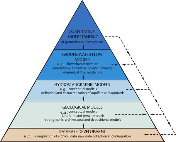
Figure 1. Simplified basin analysis approach used for regional hydrogeology analysis (Sharpe et al., 2002). The approach leads progressively from database development early in a study (base of figure) to quantitative understanding of groundwater flow systems as the study matures (top of figure).
Most presentations addressed the exploitation of common data sets that included digital elevation models (DEM), geological maps, borehole information, and geophysical data. Only a few presentations, however, (Table 2) really focused on this issue. In a few studies, geochemical, hydrochemical, and hydraulic data were incorporated. In many cases, the geologic data were archival. Archival data generally refers to data previously collected by persons other than trained geologists, such as: water well records, geotechnical data, and data from hydrogeological studies. Archival data generally do not contain adequate geological detail to infer geological processes. This is also commonly true of core descriptions from hydrogeological studies that commonly use the Universal Soil Classification, which does not capture salient, essential geological information (e.g. Fogg et al., 1998). By comparing archival data to key stratigraphic control borings and/or seismic data, particularly in areas of sparse data, some inferences and correlations can be made (Russell et al., 2006a). This is essential for improving data coverage of large study areas. Table 3 summarizes key data sets used by various studies, and illustrates how these data were used to enhance model development.
| Category | Data set | Comments |
|---|---|---|
| Map or surface | DEM | Surface relief, model elevation datum |
| Bedrock geology maps | Along with outcrop locations this data control structural surfaces | |
| Surficial geology maps | Surface control on model units, length and width scales of geological features | |
| Stratigraphic | Subsurface units, pre-interpreted model layers | |
| Archival | Waterwell records | Stratigraphy, screen intervals |
| Geotechnical | Shallow stratigraphy, physical characteristics | |
| Hydrogeological | Physical characteristics, accompanied by hydrogeological data | |
| Borehole | Continuous core | Sedimentological detail, physical characteristics |
| Petroleum wells | Bedrock stratigraphic picks | |
| Hydro-geological | Hydrochemistry | Major and trace element, CFC, stable isotopes (Tritium, oxygen, . . . ) |
| Hydraulic | ||
| Geophysics | Downhole | Gamma, conductivity, magnetic susceptibility, p and s-wave, neutron, . . . |
| Seismic reflection | High resolution shallow seismic | |
| Marine seismic | Digital and analogue high resolution |
Data management and standardization issues are central to the development of 3-D models, and more critically, to institutional progress in 3-D model development. Much of the effort in model construction goes toward data collation, preparation, standardization, and error checking (including data location verification). Development of robust, efficient data handling protocols is, consequently, essential to the cost-effective and timely delivery of individual models and institutional objectives (Gunnink, 2006; Kessler et al., 2006). A number of presentations alluded to these issues and the general workflow descriptions of model development (e.g., Figure 2).
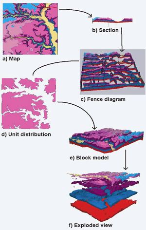
Figure 2. GSI3D (modeling software name) workflow (from Kessler et al., 2006).
The issue of data management is highlighted by the number of borehole records used in some of the regional models. For example, the Oak Ridges Moraine study has data from >100, 000 water well, geotechnical, hydrogeological, and shallow field mapping sites. In addition, continuous cored boreholes of up to 200 m can have more than 2000 logged units, 100's of grain-size and water content samples, complemented by 100s of digital images (e.g. Logan et al., 2004). Geophysical surveys, particularly in lacustrine or marine environments, can generate 10's to 1000's of kilometers of digital and analogue seismic reflection data (e.g. Thorleifson et al., 2001). At national levels, the scale of data management issues can be proportionally greater (Gunnink, 2006; Kessler et al., 2006). Fortunately, most national, state and provincial geological surveys are involved in various data standards exercises that are establishing standards from which individual studies are able to benefit (e.g. Soller, 2004; Soller and Berg, 2006).
Once data are formatted in a data structure, the work of data assessment, verification and standardization remains. In many cases, the most problematic data are the ubiquitous water well records. Issues of location accuracy are a common problem, and verification is a first step in using the data. Three different approaches were discussed, reflecting different reporting protocols (cadastral, geographic, postal address) in different jurisdictions - Illinois (Barnhardt et al., 2001), Manitoba (Thorleifson et al., 2002), and Ontario (Kenny et al., 1997).
Part of the process of "cleaning" data sets is the standardization of material descriptions to a common scheme with a limited number of unique descriptions. Once a standardized material coding scheme has been applied, all data records can be stratigraphically coded manually or programmatically. This issue was addressed in a variety of ways (Arnold et al., 2001; Ross et al., 2001; Logan et al., 2004).
Presentations at the four workshops have undergone a transition from a focus on data management issues to presentations on 3-D models, 3-D modeling software, and applications of 3-D modeling (e.g. Datamine, ; gOcad, ; Rockworks, ; Shafer et al., 2006). There was also an increase in the number of presentations that focused on the construction of small-scale regional models of large jurisdictional areas (Figure 3). These regional models address an important issue raised by LeGrand and Rosen (1998), regarding the need for regional context prior to embarking on site-specific data collection.
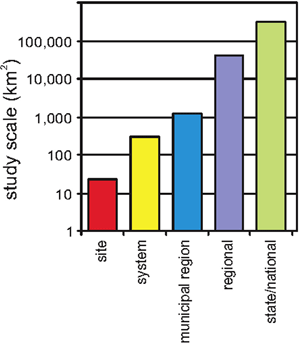
Figure 3. Summary of scale of models presented in the 2005 workshop.
3-D models have been presented for a range of study area scales and a variety of geological basins and depositional environments. Most of these studies have been regional in nature. Only a few studies have focused on modeling bedrock units (Arthur et al., 2002; Sweetkind et al., 2002) or constructing a model depicting both sediment and undeformed sedimentary rock strata (Ross et al., 2001; Thorleifson et al., 2001). A few studies have focused on specific depositional settings or landforms, for example eskers (e.g. Artimo et al., 2002; Bolduc et al., 2006).
Many studies have not clearly elucidated the approach to geological model development. Nevertheless a number of papers raise various philosophical and procedural issues regarding modeling. Philosophical issues of modeling pertain to the need for improved geological realism in models that lack adequate data support. This illustrates the difference between purely data-driven models (Logan et al., 2006) and intermediate models with an interpretive element imbedded via a synthetic data set (Soller et al., 1999; Kassenaar et al., 2004; Keller et al., 2006).
Kassenaar et al. (2004) presented one perspective on the capture of geological interpretation by blending hand drawn interpretations with on-screen stratigraphic assignments. This is an approach that has similarities with the method employed in the Red River area of Manitoba and Minnesota (Thorleifson et al., 2001; Thorleifson et al., 2002; Keller et al., 2006; Thorleifson et al., 2006). In these studies, synthetic stratigraphic picks were generated from vector surfaces along a series of cross-sections. By contrast Logan et al. (2006) used an iterative rules-based approach that stratigraphically coded archival data in a two-step process using a training data set and training surfaces. This approach has similarities to that employed in the Netherlands. Gunnink (2006) discussed an iterative process of model development where control surfaces and synthetic data are integrated into smaller scale models based on scaling of modeled features from larger scale models or by sampling earlier iterations of the model.
Many studies discussed the construction of 2.5-D models, with data management in a relational database and 2-D GIS software such as ArcInfo or MapInfo. These models build structural surfaces of unit tops and then calculate isopachs of unit thicknesses. In some cases these 2.5-D models were imported into 3-D software and converted to volume models for visualization and analysis. In 2005, many studies were using 3-D software packages to generate complete volume models (e.g. Keller et al., 2006; Malolepszy, 2006; Ross et al., 2006; Thorleifson et al., 2006; Figure 4). An important aspect of modeling is the geostatistical realization of model surface or unit heterogeneity (Ritzi, 2002; Weissemann, 2006). This was most clearly enunciated by Weissemann in a presentation on the integration of geological map data and the subsequent conditional simulation of lower resolution subsurface data.
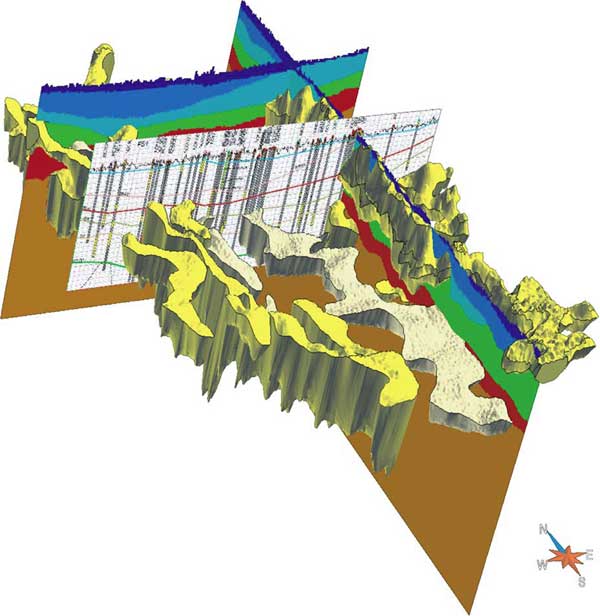
Figure 4. 3-D geology was interpreted on cross sections that were scanned in 3D space and utilized to construct 3-D solids; this example (Thorleifson et al., 2006) shows thick glacial lake clay in blue in the Fargo, North Dakota, area, and a thinner clay cover above a major aquifer in the eastern portion of that area, to the right. Note the north-south valley fills of sand interpreted as tunnel valleys.
The application of geological models to hydrogeology is the raison detre of all four workshops. The workshop organizers stressed the importance of integrating increased geological knowledge in groundwater models. A 3-D geological conceptual model based on the best available data, predictive sedimentological models, and representing the geometry and stratigraphy of all materials, can only result in improved groundwater models. Presentations on the subject of hydrogeology described methods to regionalize physical property data, transform geological model grids to hydrogeological grids, integrate geological models, and develop database-supported flow mapping. These presentations touched on a range of societal issues dealing with groundwater: potable water supply, industrial extraction, energy supply, contaminant mitigation, and radioactive waste disposal. An integration of geology, hydrostratigrahy, flow modeling and database management was presented by Shafer et al. (2006) for Coastal Plain sediment in Beaufort, South Carolina.
The value of geological mapping has only rarely been quantified (Bhagwat and Ipe, 2000). A number of presentations addressed different aspects of the societal value and economic benefit of geological mapping (Hanmer, 2004; Jackson, 2004; Troost and Booth, 2006). Troost and Booth provided a perspective on the economic cost and value of geological mapping in the Seattle area, where they illustrated the need for renewed mapping as technology changes and societal needs and expectations within densely populated urban areas increase. They highlighted, the difference between the 1962 and 2005 geological maps of the area. Differences in surface sediment types and thicknesses can have significant implications for landuse planners, zoning regulations, and for framing site investigations. To illustrate the cost effectiveness of geological mapping, Troost and Booth compared the cost of mapping a 1:12,000-scale quadrangle with other activities of similar cost ($500,000) undertaken by municipal authorities. From this analysis, they showed that the cost of 3-D mapping is comparable to a single lawsuit, 3 ground water modeling studies, or 2 reconnaissance-level route selection studies.
Recently there have been enormous developments in the promotion of geographic data through online programs such as Google Earth (http://earth.google.com). Also the British Geological Surveys national Lithoframe model (Table 4) and The Netherlands 3-D modeling program, illustrate approaches for 3-D geological mapping on national scales. Google Earth, and perhaps examples of large-scale 3-D models, will hopefully capture the imagination of viewers and serve valuable public outreach purposes. Early developments in the web-enabling of 3-D models are illustrated by links provided in Table 4. Berg and Soller (2006) demonstrated a web-enabled borehole tool for querying stacked-layer maps online. As highlighted at the third workshop by Jackson (2004) of the British Geological Survey, the fundamental purpose of national geological surveys (and state and provincial surveys as well) is serving public need. Google Earth has demonstrated that there is an overwhelming public interest in geospatial data when linked to issues or themes with which the public can identify, and in an interface that is easy to manage.
| Jurisdiction | Site Information | URL |
|---|---|---|
| Great Britain | Lithoframe; national model of Great Britian | http://www.bgs.ac.uk/science/3Dmodelling/lithoframe1M.html |
| Netherlands | National model of Netherlands | http://www.nitg.tno.nl/ned/projects_new/pdf_s/2_09eng.pdf |
| Manitoba | 3-D Model of Manitoba | http://www.gov.mb.ca/iedm/mrd/geo/3dmodel/index.html#introduction |
| Illinois | East-central 3-D model | http://ngmdb.usgs.gov/ecill/ |
| Seattle | GeoMapNW | http://geomapnw.ess.washington.edu/ |
Conflicting land use and urbanization problems stimulate interest for generating 3-D models for groundwater studies. Often in jurisdictions with abundant water, the resource is not equally distributed or accessible. Furthermore, dwindling aggregate resources, increasing practice of industrial agriculture, and the demand for alternative energy supplies (geothermal, coal bed methane, heavy oil) will ensure that groundwater resource and protection issues remain a central theme. Geologists need to embrace other disciplines (geostatistics, hydrochemistry, hydrogeology) as they attempt to move beyond first-order stratigraphic models to more complete models of the basin subsurface. It is evident that geologists have responded to a central recommendation of Anderson (1989), because many are now indeed familiar with 3-D numeric model construction, and can synthesize data in conceptual geological models and integrate data into flow models. It is also apparent that it is not only geologists in the USA and Canada who are grappling with this issue; it is of interest in many countries (e.g., Culshaw, 2005). Through the development of GIS-based digital geological models, geologists are becoming better positioned to support hydrogeological flow modeling exercises.
Reviews at the GSC by R. Knight and at the ISGS by J. Goodwin are much appreciated.
Anderson, M.P., 1989, Hydrogeologic facies models to delineate large-scale spatial trends in glacial and glaciofluvial sediments: Geological Society of America Bulletin, v. 101, p. 501-511.
ArcInfo,http://www.esri.com/.
Arnold, T.L., Friedel, M.J., and Warner, K.L., 2001, Hydrogeological inventory of the upper Illinois River BasinCreating a large database from well construction records, in Berg, R.C., and Thorleifson, L.H., eds., Geological Models for Groundwater Flow Modeling, 35th annual meeting, north-central section GSA: Bloomington-Normal, Illinois, Illinois State Geological Survey, Open File Series 2000-1, p. 1-5.
Arthur, J.D., Cichon, J., Baker, A., Marquez, J., Rudin, A., and Wood, A., 2002, Hydrogeological mapping and aquifer vulnerability modeling in Florida: 2D and 3D data analysis and visulaization, in Thorleifson, L.H., and Berg, R.C., eds., Three-Dimensional Geological Mapping for Groundwater Applications: Workshop Extended Abstracts: Ottawa, Ontario, Geological Survey of Canada, Open File 1449, p. 1-4.
Three-dimensional geological modeling of the Virttaankangas aquifer, southwestern Finland, in Thorleifson, L.H., and Berg, R.C., eds., Three-Dimensional Geological Mapping for Groundwater Applications: Workshop Extended Abstracts: Ottawa, Ontario, Geological Survey of Canada, Open File 1449, p. 5-7.
ASTM, 1998, Standard guide for conceptualization and characterization of ground-water systems, D 5979-96, American Society for Testing Materials (ASTM) standards on design, planning, and reporting of ground water and vadose zone investigations, 2nd edition (Second Edition ed.): West Conshohocken, PA, ASTM, p. 278-284.
Barnhardt, M.L., Hansel, A.K., and Stumpf, A.J., 2001, Developing the database for 3-D modeling: aquiring, assembling, verifying assessing, interpreting and integrating source data, in Berg, R.C., and Thorleifson, L.H., eds., Geological Models for Groundwater Flow Modeling, 35th annual meeting, north-central section GSA: Bloomington-Normal, Illinois, Illinois State Geological Survey, Open File Series 2000-1, p. 6.
Berg, R.C., Bleuer, N.K., Jones, B.E., Kincare, K.A., Pavey, R.R., and Stone, B.D., 1999, Mapping the glacial geology of the central Great Lakes region in three-dimensionsa model for State-Federal cooperation: U.S. Geological Survey, Open-File Report 99-349.
Berg, R.C., McKay, E.D., Keefer, D.A., Bauer, R.A., Johnstone, P.D., Stiff, B.J., Pugin, A., Weibel, C.P., Stumpf, A.J., Larson, T.H., Su, W.J., and Homrighous, G.T., 2002, Three-dimensional geological mapping for transportation planning in central-northern Illinois: Data selectioin, map construction, and model development, in Thorleifson, L.H., and Berg, R.C., eds., Three-Dimensional Geological Mapping for Groundwater Applications: Workshop Extended Abstracts: Ottawa, Ontario, Geological Survey of Canada, Open File 1449, p. 13-17.
Berg, R.C., Russell, H.A.J., and Thorleifson, L.H., 2004, Three-dimensional geological mapping for groundwater applications: Illinois State Geological Survey, Open File Series 2004-8.
Berg, R.C., and Soller, D.R., 2006, Toward a goal of a "Super" three-dimensional geological map, in Russell, H.A.J., Berg, R.C., and Thorleifson, L.H., eds., Three-dimensional geological mapping for groundwater applications, Geological Survey of Canada, Open File 5048, p. 11-16.
Berg, R.C., and Thorleifson, L.H., 2001, Geological Models for Groundwater Flow Modeling: Illinois State Geological Survey, Open File Series 2000-1.
Bhagwat, S.B., and Ipe, V.C., 2000, Value of geological quadrangle maps of Kentucky: Illinois State Geological Survey, Special Report 3.
Bridge, D.M., Hough, E., Kessler, H., Lelliott, M., Price, S.J., and Reeves, H.J., 2004, Integrating modelling of geoscience information to suport sustainable urban planning, Greater Manchester Area, Northwest England, in Berg, R.C., Russell, H.A.J., and Thorleifson, L.H., eds., Three-dimensional geological mapping for groundwater applications, Illinois State Geological Survey, Open File Series 2004-8, p. 16-19.
Culshaw, M.G., 2005, From concept toward reality: developing the attributed 3D geological model of the shallow subsurface: Quarterly Journal of Engineering Geology and Hydrogeology, v. 38, p. 231-284.
Datamine, http://www.datamine.co.uk/.
Fogg, G.E., 1986, Groundwater flow and sand body interconnectedness in a thick multiple-aquifer system: Water Resources Journal, v. 22, p. 679-694.
Fogg, G.E., Noyes, C.D., and Carle, S.F., 1998, Geological based model of heterogeneous hydraulic conductivity in an alluvial setting: Hydrogeology Journal, v. 6, p. 131-143.
gOcad, 2005, http://www.earthdecision.com/.
Google Earth, http://earth.google.com.
Gunnink, J.L., 2006, Geological mapping in the Netehrlands: The case of the shallow subsurface (-550 m), in Russell, H.A.J., Berg, R.C., and Thorleifson, L.H., eds., Three- dimensional geological mapping for groundwater applications: Workshop Extended Abstracts, Geologial Survey of Canada, Open File 5048, 104 p, p. 26-29.
Hanmer, S., 2004, Cooperative geological mapping strategies across Canada: What relevance for groundwater?, in Berg, R.C., Russell, H.A.J., and Thorleifson, L.H., eds., Three-dimensional geological mapping for groundwater applications, Illinois State Geological Survey, Open File Series 2004-8, p. 21-22.
Houlding, S.W., 1994, 3D Geoscience Modeling, Computer Techniques for Geological Characterization, Springer Verlag, 309 p.
Hughes, J.D., 1993, GEOMODEL; an expert system for modeling layered geological sequences applied to the assessment of coalfields, in Kirkham, R.V., Sinclair, W.D., Thorpe, R.I., and Duke, J.M., eds., Mineral Deposit Modeling, Geological Association of Canada, Special Paper 40, p. 707-734.
Jackson, I., 2004, Communicating the Vision?, in Berg, R.C., Russell, H.A.J., and Thorleifson, L.H., eds., Three-dimensional geological mapping for groundwater applications, Illinois State Geological Survey, Open File Series 2004-8, p. 32-34.
Kassenaar, D., Gerber, R., and Holysh, S., 2004, Merging conceptual insight and secondary indicators into the hydrogeological modeling process: Examples from the Oak Ridges Moraine, southern Ontario, in Berg, R.C., Russell, H.A.J., and Thorleifson, L.H., eds., Three-dimensional geological mapping for groundwater applications, Illinois State Geological Survey, Open File Series 2004-8, p. 35-39.
Keller, G.R., Matile, G.L.D., Thorleifson, L.H., and Malolepszy, Z., 2006, 3D geological model of the Red River Valley, central North America, in Russell, H.A.J., Berg, R.C., and Thorleifson, L.H., eds., Three-dimensional geological mapping for groundwater applications, Geological Survey of Canada, Open File 5048, p. 34-37.
Kenny, F.M., Chan, P., and Hunter, G., 1997, Quality control of the Positional Accuracy of Records in Ontarios Water well database using automated GIS techniques, in Conference Proceedings Geomatics in the Era of RADARSAT GER 97, Ottawa, May 24-30, 1997, http://gsc.nrcan.gc.ca/hydrogeo/orm/pdf/kenny_et_al_1997.pdf.
Kessler, H., Lelliott, M., Bridge, D.M., Ford, J., Sobusch, H.-G., Mathers, S., Price, S., Merritt, J., and Royse, K., 2006, 3D Geoscience models and their delivery to customers, in Russell, H.A.J., Berg, R.C., and Thorleifson, L.H., eds., Three-dimensional geological mapping for groundwater applications, Geological Survey of Canada, Open File 5048, p. 38-41.
LeGrand, H.E., and Rosen, L., 1998, Putting hydrogeological site studies on track: Ground Water, v. 36, p. 193-194.
Logan, C., Russell, H.A.J., and Sharpe, D.R., 2004, A stratigraphic database approach to 3-D modelling in the Oak Ridges Moraine Area, southern Ontario, in Berg, R.C., Russell, H.A.J., and Thorleifson, L.H., eds., Three-dimensional geological mapping for groundwater applications, Illinois State Geological Survey, Open File Series 2004-8, p. 45-47.
Logan, C., Russell, H.A.J., Sharpe, D.R., and Kenny, F.M., 2006, The role of expert knowledge, GIS and geospatial data management in a basin analysis, Oak Ridges Moraine, southern Ontario, in Harris, J., ed., GIS Applications in the Earth Sciences, Geological Association of Canada, p. 523-545.
Malolepszy, Z., 2006, Three-dimensional geological model of Poland and its application to geothermal resource assessment, in Russell, H.A.J., Berg, R.C., and Thorleifson, L.H., eds., Three-dimensional geological mapping for groundwater applications, Geological Survey of Canada, Open File 5048, p. 45-48.
MapInfo, http://www.mapinfo.com/.
National Research Council, 2000, Investigating groundwater systems on regional and national scales: Committee on USGS Water Reources Research, Water Science and Technology Board: Washington, DC., National academy Press, National Research Council.
Ritzi, R.W.J., 2002, Three-dimensional aquifer mapping using indicator geostatistics, in Thorleifson, L.H., and Berg, R.C., eds., Three-Dimensional Geological Mapping for Groundwater Applications: Workshop Extended Abstracts: Ottawa, Ontario, Geological Survey of Canada, Open File 1449, p. 51.
Rivera, A., Crowe, A., Kohut, A., Rudolph, D., Baker, C., Pupek, D., Shaheen, N., Lewis, M., and Parks, K., 2003, Canadian framework for collaboration on groundwater: Ottawa, Ontario, Geological Survey of Canada, 55 p.
Rockworks, 2006, http://www.rockware.com/set.html.
Ross, M., Aitssi, L., Martel, R., and Parent, M., 2006, From geological to groundwater flow models: an example fo inter-operability for semi-regular grids, in Russell, H.A.J., Berg, R.C., and Thorleifson, L.H., eds., Three-dimensional geological mapping for groundwater applications, Geological Survey of Canada, Open File 5048, p. 62-64.
Ross, M., Parent, M., Michaud, M., Boisvert, E., and Girard, F., 2001, On the construction of 3D geological models for applicatioins in regional hydrogeology in complex Quaternary terrains of eastern Canada, in Berg, R.C., and Thorleifson, L.H., eds., Geological Models for Groundwater Flow Modeling, 35th annual meeting, north-central section GSA: Bloomington-Normal, Illinois, Illinois State Geological Survey, Open File Series 2000-1, p. 34-37.
Russell, H.A.J., Berg, R.C., and Thorleifson, L.H., 2006, Three-dimensional geological mapping for groundwater applications: Geological Survey of Canada, Open File 5048.
Russell, H.A.J., Pullan, S.E., Hunter, J.A., Sharpe, D.R., and Holysh, S., 2004, Buried-valley aquifers: Delineation and characterization from reflection seismic and core data Caledon East, Ontario, in Berg, R.C., Russell, H.A.J., and Thorleifson, L.H., eds., Three-dimensional geological mapping for groundwater applications, Illinois State Geological Survey, Open File Series 2004-8, p. 73-76.
Shafer, J.M., Covington, E., Rine, J.M., and Berg, R.C., 2006, Incorporation of groundwater flow into traditional sensitivity analysis of a southeast coastal plain layered aquifer system, in Russell, H.A.J., Berg, R.C., and Thorleifson, L.H., eds., Three-dimensional geological mapping for groundwater applications, Geological Survey of Canada, Open File 5048, p. 70-74.
Shafer, J.M., Rine, J.M., Waddell, M.G., and Berg, R.C., 2002, 3D hydrogeological characterization of the marine corps air station at Beaufort, South Carolina for aquifer vulnerability analysis and groundwater flow and transport modeling, in Thorleifson, L.H., and Berg, R.C., eds., Three-Dimensional Geological Mapping for Groundwater Applications: Workshop Extended Abstracts: Ottawa, Ontario, Geological Survey of Canada, Open File 1449, p. 58-61.
Sharpe, D.R., Hinton, M.J., Russell, H.A.J., and Desbarats, A.J., 2002, The need for basin analysis in regional hydrogeological studies: Oak Ridges Moraine, Southern Ontario: Geoscience Canada, v. 29, no. 1, p. 3-20.
Soller, D.R., 2004, Facillitating 3-D analysis with standardization Information - The role of the National Geological Map Database, in Berg, R.C., Russell, H.A.J., and Thorleifson, L.H., eds., Three-dimensional geological mapping for groundwater applications, Illinois State Geological Survey, Open File Series 2004-8, p. 85-88.
Soller, D.R., and Berg, R.C., 2006, The national geological map database project: Overview and progress, in Soller, D.R., ed., DMT03 - Digital Mapping techniques Proceedings, U.S. Geological Survey, Open-file Report 03-471.
Soller, D.R., Price, S.D., Kempton, J.P., and Berg, R.C., 1999, Three-dimensional geological maps of Quaternary sediments in east-central Illinois, USGS I-Map 2669, Three atlas sheets.
Stone, B.A., Kincare, K.A., and OLeary, D.W.O., 2002, Glacial geology mapping in Barrien County, Michigan: Resolving the third dimension for increasing the accuracy of resource assessment, in Thorleifson, L.H., and Berg, R.C., eds., Three-Dimensional Geological Mapping for Groundwater Applications: Workshop Extended Abstracts: Ottawa, Ontario, Geological Survey of Canada, Open File 1449, p. 67-70.
Sun, R.J., and Johnson, R.H., 1994, Regional Aquifer-Systems Analysis Program of the U.S. Geological Survey, 1978-92: U.S. Geological Survey, Circular 1099.
Sweetkind, D.S., Belcher, W.R., and Faunt, C.C., 2002, Hydrogeological framework construction, using an example from the Death Valley ground-water flow system, Nevada and California, USA, in Thorleifson, L.H., and Berg, R.C., eds., Three-Dimensional Geological Mapping for Groundwater Applications: Workshop Extended Abstracts: Ottawa, Ontario, Geological Survey of Canada, Open File 1449, p. 71-74.
Thorleifson, L.H., Berg, J.A., Tipping, R., G, Harris, K.L., Lusardi, B.A., Setterholm, D.R., Malolepszy, Z., and Anderson, F.J., 2006, 3D geological modeling in support of groundwater inventory in the Fargo-Moorhead region, Minnesota and North Dakota, in Russell, H.A.J., Berg, R.C., and Thorleifson, L.H., eds., Three-dimensional geological mapping for groundwater applications, Geological Survey of Canada, Open File 5048, p. 92-95.
Thorleifson, L.H., and Berg, R.C., 2002, Three-Dimensional Geological Mapping for Groundwater Applications: Workshop Extended Abstracts: Geological Survey of Canada, Open File 1449.
Thorleifson, L.H., Matile, G.L.D., Keller, G.R., and Pyne, D.M., 2002, Construction of a geological model for southern Manitoba for groundwater modelling, in Thorleifson, L.H., and Berg, R.C., eds., Three-Dimensional Geological Mapping for Groundwater Applications: Workshop Extended Abstracts: Ottawa, Ontario, Geological Survey of Canada, Open File 1449, p. 75-78.
Thorleifson, L.H., Matile, G.L.D., Pyne, D.M., and Keller, G.R., 2001, Construction of a geological model of the Winnipeg region for groundwater modeling, in Berg, R.C., and Thorleifson, L.H., eds., Geological Models for Groundwater Flow Modeling, 35th annual meeting, north-central section GSA: Bloomington-Normal, Illinois, Illinois State Geological Survey, Open File Series 2000-1, p. 52-54.
Troost, K.G., Booth, D.A., Shimel, S.A., and ONeal, M.A., 2001, The Seattle-area geological mapping project and the geological framework of Seattle, in Berg, R.C., and Thorleifson, L.H., eds., Geological Models for Groundwater Flow Modeling, 35th annual meeting, north-central section GSA: Bloomington-Normal, Illinois, Illinois State Geological Survey, Open File Series 2000-1, p. 58-61.
Troost, K.G., and Booth, D.B., 2006, Cost of 1:12,000-scale geological map; $500,000: Cost of 3D data, priceless, in Russell, H.A.J., Berg, R.C., and Thorleifson, L.H., eds., Three-dimensional geological mapping for groundwater applications: Workshop Extended Abstracts, Geologial Survey of Canada, Open File 5048, p. 96-99.
Weissemann, G., 2006, Application of transition probability geostatistics in a detailed stratigraphic framework, in Russell, H.A.J., Berg, R.C., and Thorleifson, L.H., eds., Three-dimensional geological mapping for groundwater applications: Workshop Extended Abstracts, Geologial Survey of Canada, Open File 5048, p. 100-103.
Yarus, J.M., and Chambers, R.L., eds., 1994, Stochastic modeling and geostatistics: principles, methods, and case studies: AAPG Computer Applications in Geology, no 3, The American Association of Petroleum Geologists, 379 p.

![]() U.S. Department of the Interior |
U.S. Geological Survey
U.S. Department of the Interior |
U.S. Geological Survey
URL: pubsdata.usgs.gov /pubs/of/2005/1428/russell/index.html
Page Contact Information: David R. Soller
Page Last Modified: Saturday, 12-Jan-2013 22:05:12 EST
