link to main US Geological Survey website
U.S. Geological Survey
Open-File Report 2005-1444
Version 1.0

Gravity and Ground Magnetic Data from Selected Traverses in the Amargosa Desert and Vicinity, Nevada and California

By Edward A. Mankinen, Donald S. Sweetkind, Edwin H. McKee, and Robert L. Morin

2005

map showing location of study area.  Nevada-California state line runs through the middle, Death Valley to the west, Nevada Test Site to the northeast.  Las Vegas off the map to the southeast.  Rock types are colored as Cenozoic sedimentary rocks in putty, Cenozoic volcanic rocks in tan, Mesozoic and Cenozoic intrusive rocks in red, Mesozoic sedimentary rocks in green, Paleozoic siliciclastic rocks in olive, Paleozoic carbonate rocks in blue, and Late Proterozoic to Early Cambrian metamorphic and silciclastic rocks in brown
Index map showing location of Amargosa Desert basin study area (outlined) and distribution of main geologic units of the surrounding region (from figure 1)

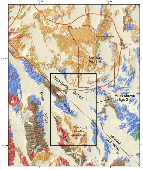
High-resolution aeromagnetic surveys of the Amargosa Desert region have revealed many magnetic anomalies of varying character. High-amplitude anomalies in the northern part of the region are produced by the volcanic rocks of the southern Nevada volcanic field (SNVF). Contrasted with these are low-amplitude anomalies over a broad area in the southern and southwestern part of the aeromagnetic survey that reflect pre-Cenozoic, largely nonmagnetic basement rocks exposed in the different ranges. More subtle, isolated anomalies are distributed throughout the region and indicate sources that are overlain by, or included within, the alluvial deposits. We have investigated some of the latter low-amplitude anomalies using gravity and magnetic techniques in an attempt to help characterize their causative bodies. Our depth-to-magnetic-source calculations indicate that the anomalies investigated have sources within the alluvial fill and agree well with results from similar studies in the region. Possible source rocks include Miocene tuff of the SNVF and/or Tertiary rocks of the Death Valley volcanic field.

Download this report as a 43-page PDF document (of2005-1444.pdf; 21.9 MB)

GIS data (shapefile): 2005-1444.zip
Metadata (text): metadata.met

For questions about the content of this report, contact Ed Mankinen.

Version history


Download a current version of Adobe Reader for free

| Help | PDF help | Publications main page | Open-File Reports for 2005 |
| Privacy Statement | Disclaimer | Accessibility |
| Geologic Division | Geophysical Unit of Menlo Park, Calif. (GUMP) |

This report is available only on the Web


| Department of the Interior | U.S. Geological Survey |
URL of this page: http://pubs.usgs.gov/of/2005/1444/
Maintained by: Michael Diggles
Date created: February 18, 2006
Date last modified: June 5, 2008 (jmw)