|
Introduction
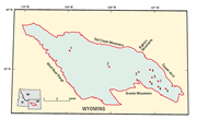
The Wind River Basin is a large Laramide (Late Cretaceous
through Eocene) structural and sedimentary basin that
encompasses about 7,400 mi2 in central Wyoming. The
basin boundaries are defined by fault-bounded Laramide uplifts
that surround it, including the Owl Creek and Bighorn Mountains
to the north, Wind River Range to the west, Granite Mountains
to the south, and Casper Arch to the east. The purpose of this report is
to present new vitrinite reflectance data to be used in support of
the U.S Geological Survey assessment of undiscovered oil and
gas resources of the Wind River Basin.
One hundred and nineteen samples were collected from
Jurassic through Tertiary rocks, mostly coal-bearing strata, in an effort to better understand and characterize
the thermal maturation and burial history of potential source
rocks.
|

