Skip Links

USGS - science for a changing world

Open-File Report 2006–1017

Earthquakes in Virginia and Vicinity 1774 − 2004

By Arthur C. Tarr and Russell L. Wheeler

Thumbnail of and link to report PDFAbstract

This map summarizes two and a third centuries of earthquake activity. The seismic history consists of letters, journals, diaries, and newspaper and scholarly articles that supplement seismograph recordings (seismograms) dating from the early twentieth century to the present. All of the pre- instrumental (historical) earthquakes were large enough to be felt by people or to cause shaking damage to buildings and their contents. Later, widespread use of seismographs meant that tremors too small or distant to be felt could be detected and accurately located.

Earthquakes are a legitimate concern in Virginia and parts of adjacent States. Moderate earthquakes cause slight local damage somewhere in the map area about twice a decade on the average. Additionally, many buildings in the map area were constructed before earthquake protection was added to local building codes. The large map shows all historical and instrumentally located earthquakes from 1774 through 2004.

First posted April 2006

For additional information:

U.S. Geological Survey Earthquake Hazards Program

http://earthquake.usgs.gov/

The site contains regional, national, and global earthquake information and links to other sites.

Part of this report is presented in Portable Document Format (PDF); the latest version of Adobe Reader or similar software is required to view it. Download the latest version of Adobe Reader, free of charge.


Suggested citation:

Tarr, Arthur C., and Wheeler, Russell L., 2006, Earthquakes in Virginia and vicinity 1774 - 2004: U.S. Geological Survey Open-File Report 2006–1017.
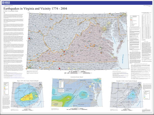


Contents

Earthquakes

Eastern U.S. Earthquakes

Earthquakes in and Near Virginia

Seismic Hazard

Abbreviated Modified Mercalli Intensity Scale

Intensity and Magnitude

Technical Notes

A Note on the Intensities of the 1897 Giles County Earthquake

Community Internet Intensity Map

Significant Seismic Events 1774-2004 Virginia and Vicinity

Information Sources on the Web

Data Sources

References Cited and Additional Scientific Articles


Accessibility FOIA Privacy Policies and Notices

Take Pride in America logo USA.gov logo U.S. Department of the Interior | U.S. Geological Survey
URL: http://pubsdata.usgs.gov/pubs/of/2006/1017/index.html
Page Contact Information: GS Pubs Web Contact
Page Last Modified: Saturday, 12-Jan-2013 21:03:03 EST