|
|
|
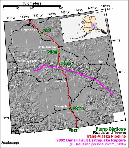
In September, 2003, the Alyeska Pipeline Service Company (APSC) and the U.S. Geological Survey (USGS) embarked on a joint effort to extract, test, and calibrate the accelerometers, amplifiers, and bandpass filters from the earthquake monitoring systems (EMS) at Pump Stations 09, 10, and 11 of the Trans-Alaska Pipeline System (TAPS). These were the three closest strong-motion seismographs to the Denali fault when it ruptured in the MW 7.9 earthquake of 03 November 2002 (22:12:41 UTC). The surface rupture is only 3.0 km from PS10 and 55.5 km from PS09 but PS11 is 124.2 km away from a small rupture splay and 126.9 km from the main trace. Here we briefly describe precision calibration results for all three instruments. Included with this report is a link to the seismograms reprocessed using these new calibrations: http://nsmp.wr.usgs.gov/data_sets/20021103_2212_taps.html Calibration information in this paper applies at the time of the Denali fault earthquake (03 November 2002), but not necessarily at other times because equipment at these stations is changed by APSC personnel at irregular intervals. In particular, the equipment at PS09, PS10, and PS11 was changed by our joint crew in September, 2003, so that we could perform these calibrations. The equipment stayed the same from at least the time of the earthquake until that retrieval, and these calibrations apply for that interval. |
Download this publication as a PDF file (of2006-1028.pdf; 55 pages, 14.4 MB)
We have also provided individual files for the figures and tables as well as .zip files of the entire collection of figures of tables:
Go to the Figures folder (31 figures that total 17 MB or one .zip file that is 9.5 MB)
Go to the Tables folder (14 tables that total 440 KB or one .zip file that is 80 KB)
For questions about the content of this report, contact John Evans
| Help
| PDF help
| Publications main page
| Open-File
Reports for 2006
|
This report is available only on the web.