|
|
|
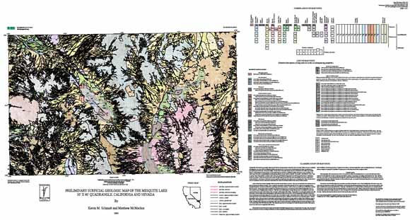
The Quaternary surficial geologic map of the Mesquite Lake, California-Nevada 30'X60' quadrangle depicts deposit age and geomorphic processes of erosion and deposition, as identified by a composite of remote sensing investigations, laboratory analyses, and field work, in the arid to semi-arid Mojave Desert area, straddling the California-Nevada border. Mapping was motivated by the need to address pressing scientific and social issues such as understanding and predicting the effects of climate and associated hydrologic changes, human impacts on landscapes, ecosystem function, and natural hazards at a regional scale. As the map area lies just to the south of Las Vegas, Nevada, a rapidly expanding urban center, land use pressures and the need for additional construction materials are forecasted for the region. The map contains information on the temporal and spatial patterns of surface processes and hazards that can be used to model specific landscape applications. Key features of the geologic map include: (1) spatially extensive Holocene alluvial deposits that compose the bulk of Quaternary units (~25%), (2) remote sensing and field studies that identified fault scarps or queried faults in the Kingston Wash area, Shadow Mountains, southern Pahrump Valley, Bird Spring Range, Lucy Gray Mountains and Piute Valley, (3) a lineament indicative of potential fault offset is located in Mesquite Valley, (4) active eolian dunes and sand ramps located on the east side of Mesquite, Ivanpah, and Hidden Valleys adjacent to playas, (4) groundwater discharge deposits in southern Pahrump Valley, Spring Mountains, and Lucy Gray Mountains and (5) debris-flow deposits spanning almost the entire Quaternary period in age. |
Download this ReadMe file for this publication as a 13-page PDF document (ReadMe_of06_1035.pdf; 272 KB)
Download this ReadMe file for this publication as an ASCII document (ReadMe_of06_1035.txt; 40 KB)
Download this map as a 72" x 36" PDF document (of06_1035_3a.pdf; 9.6 MB)
Download the pamphlet as an 89-page PDF document (of06_1035_3a.pdf; 7.8 MB)
Download the metadata in HTML form (of06_1035_1a.html; 64 KB)
Download the metadata in ASCII form (of06_1035_1a.txt; 64 KB)
Download the data as a .zip file (of06_1035.zip; 24.3 MB that opens into a 40.7-MB folder)
For questions about the content of this report, contact Kevin Schmidt.
| Help
| PDF help
| Publications main page | Open-File
Reports for 2006 |