|
|
|
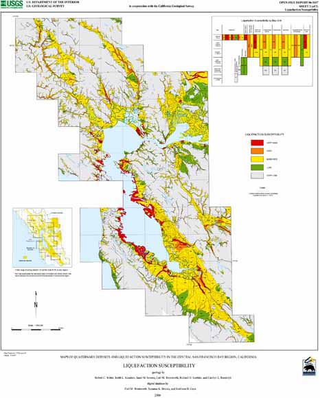
This report presents a map and database of Quaternary deposits and liquefaction susceptibility for the urban core of the San Francisco Bay region. It supercedes the equivalent area of U.S. Geological Survey Open-File Report 00-444 (Knudsen and others, 2000), which covers the larger 9-county San Francisco Bay region. The report consists of (1) a spatial database, (2) two small-scale colored maps (Quaternary deposits and liquefaction susceptibility), (3) a text describing the Quaternary map and liquefaction interpretation (part 3), and (4) a text introducing the report and describing the database (part 1). All parts of the report are digital; part 1 describes the database and digital files and how to obtain them by downloading across the internet. The nine counties surrounding San Francisco Bay straddle the San Andreas fault system, which exposes the region to serious earthquake hazard (Working Group on California Earthquake Probabilities, 1999). Much of the land adjacent to the Bay and the major rivers and streams is underlain by unconsolidated deposits that are particularly vulnerable to earthquake shaking and liquefaction of water-saturated granular sediment. This new map provides a consistent detailed treatment of the central part of the 9-county region in which much of the mapping of Open-File Report 00-444 was either at smaller (less detailed) scale or represented only preliminary revision of earlier work. Like Open-File Report 00-444, the current mapping uses geomorphic expression, pedogenic soils, inferred depositional environments, and geologic age to define and distinguish the map units. Further scrutiny of the factors controlling liquefaction susceptibility has led to some changes relative to Open-File Report 00-444: particularly the reclassification of San Francisco Bay mud (Qhbm) to have only MODERATE susceptibility and the rating of artificial fills according to the Quaternary map units inferred to underlie them (other than dams ? adf). The two colored maps provide a regional summary of the new mapping at a scale of 1:200,000, a scale that is sufficient to show the general distribution and relationships of the map units but not to distinguish the more detailed elements that are present in the database. The report is the product of cooperative work by the National Earthquake Hazards Reduction Program (NEHRP) and National Cooperative Geologic Mapping Program of the U.S. Geological Survey, William Lettis and & Associates, Inc. (WLA), and the California Geological Survey. An earlier version was submitted to the U.S. Geological Survey by WLA as a final report for a NEHRP grant (Witter and others, 2005). The mapping has been carried out by WLA geologists under contract to the NEHRP Earthquake Program (Grant 99-HQ-GR-0095) and by the California Geological Survey. |
|
File
name
|
Description
|
File
size
|
|
1. Open-File Text
|
||
| of06-1037_1a.txt | ASCII file |
72 KB
|
| of06-1037_1b.eps | Postscript file |
112 KB
|
| of06-1037_1c.pdf | PDF file |
84 KB
|
|
2. Revision List
|
||
| of06-1037_2a.txt | ASCII file |
48 KB
|
|
3. Quaternary Deposits and Liquefaction Description
|
||
| of06-1037_3a.txt | ASCII file |
124 KB
|
| of06-1037_3b.eps | Postscript file |
248 KB
|
| of06-1037_3c.pdf | PDF file |
3.2 MB
|
|
4. Quaternary Deposits Database
|
||
| of06-1037_4a.e00.zip | Quaternary deposits - compressed ArcInfo export coverage |
9.6 MB
|
| of06-1037_4b.shp.zip | Quaternary deposits - ArcMap line and polygon shape files bundled as one compressed zip file |
16.5 MB
|
|
5. Quaternary Deposits Map (image)
|
||
| of06-1037_5a.eps.zip | Postscript file, compressed |
11.9 MB
|
| of06-1037_5b.pdf.zip | PDF file, compressed |
12.1 MB
|
|
6. Liquefaction Susceptibility Map (image)
|
||
| of06-1037_6a.eps.zip | Postscript file, compressed |
11.8 MB
|
| of06-1037_6b.pdf.zip | PDF file, compressed |
12.1 MB
|
|
7. Database Package
|
||
| of06-1037_7a.zip | ARC version: Assembled text (parts 1, 2, 3, 9), ArcInfo export databases (part 4), and import.aml, bundled as one compressed zip file |
12.4 MB
|
| of06-1037_7b.zip | ArcView version: Assembled text (parts 1, 2, 3, 9) and ArcMap database shape files (part 4), bundled as one compressed zip file |
19.4 MB
|
|
8. Plotfile Package
|
||
| of06-1037_8a.zip | Postscript version: plot files for the Quaternary deposits map (part 5) and the liquefaction susceptibility map (part 6) bundled as one compressed zip file |
23.7 MB
|
| of06-1037_8b.zip | PDF version: plot files for the the Quaternary deposits map (part 5) and the liquefaction susceptibility map (part 6) bundled as one compressed zip file |
24.3 MB
|
|
9. Metadata for spatial database
|
||
| of06-1037_9.meta.txt | ASCI file |
52 KB
|
For questions about the content of this report, contact Carl Wentworth
| Help
| PDF help
| Publications main page
| Open-File
Reports for 2006
|
This report is available only on the web.