U.S. Geological Survey
Open-file Report 2006-1081
Geologic Characteristics of Benthic Habitats in Glacier Bay, Southeast AlaskaVersion 1.0 By Jodi N. Harney1, Guy R. Cochrane1, Lisa L. Etherington2, Pete Dartnell3, Nadine E. Golden1, and Hank Chezar3 |
||||||||||
|
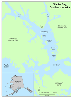
Figure 1. Location map of Glacier Bay National Park and Preserve, southeast Alaska. To view a large version of Figure 1 in a new window, click on the image above. AbstractIn April 2004, more than 40 hours of georeferenced submarine digital video was collected in water depths of 15-370 m in Glacier Bay to (1) ground-truth existing geophysical data (bathymetry and acoustic reflectance), (2) examine and record geologic characteristics of the sea floor, and (3) investigate the relation between substrate types and benthic communities, and (4) construct predictive maps of seafloor geomorphology and habitat distribution. Common substrates observed include rock, boulders, cobbles, rippled sand, bioturbated mud, and extensive beds of living horse mussels and scallops. Four principal sea-floor geomorphic types are distinguished by using video observations. Their distribution in lower and central Glacier Bay is predicted using a supervised, hierarchical decision-tree statistical classification of geophysical data. Citation: Harney, J.N., Cochrane, G.R., Etherington, L.L., Dartnell, P., Golden, N.E., and Chezar, H., 2005, Geologic characteristics of benthic habitats in Glacier Bay, southeast Alaska. U.S. Geological Survey Open-File Report 2006-1081. Available online at http://pubs.usgs.gov/of/2006/1081/. IntroductionGeologic substrates of the sea floor in southeast Alaska provide benthic habitats for recreationally and commercially important species, including halibut, rockfish, shrimp, and king, Dungeness, and Tanner crabs. The study of benthic habitat structure, function, and change is particularly important in high latitudes, where fisheries and complex food webs serve as a global resource, and where signs of climate change are more conspicuous than in other parts of the world. In Glacier Bay, historical rates of glacier retreat are among the highest documented worldwide: more than 45 km (28 miles) since 1899. Recent work with NASA LandSat7 imagery (http://landsat.gsfc.nasa.gov) revealed that Muir Glacier, at the head of the bay's east arm, retreated more than 7 km in the last 25 years (Hall et al. 1995). Large volumes of fine sediment associated with glacier meltwater can result in rapid proglacial sedimentation. For example, in front of Muir Glacier, the average rate of sediment accumulation between 1900 and 1979 was 37 mm/y (Koppes and Hallet, 2002). These data suggest that some sediment deposits that are meters thick can accumulate on the seafloor on decadal timescales. The effect of such substrate changes on the structure and function of benthic communities is not well understood, nor are the rates at which these processes and responses occur. We use geophysical data, underwater video, and sedimentologic tools to understand the geologic characteristics of the seafloor and the present distribution of benthic communities in Glacier Bay. Seafloor morphologic features and sediment texture are revealed in high-resolution, multibeam bathymetry and acoustic reflectance (backscatter) data previously collected in lower Glacier Bay (Carlson et al. 2002, 2003). Observations of seafloor video were logged real-time in the field by a team of geologists and biologists who examined areas of transition between contrasting substrate types, resolved and characterized unique seafloor features, and linked the geology and biology of benthic environments (Etherington et al. 2006; Harney et al. 2006). Common substrates observed include unsorted glacial till (boulders, cobbles, and sand), bioturbated mud, channelized mud, and rippled, coarse-grained sand. Common subtidal biota observed include benthic and demersal fish (including halibut, flounder, sole, pollock, cod, rockfish, and sculpin), several species of crabs, numerous shrimp, high-biomass beds of horse mussels and scallops, and sessile/less mobile invertebrates such as gorgonians, sea pens, echinoderms, anemones, sponges, and urchins. Bathymetry and acoustic backscatter data were compiled with geologic and biologic video observations in an ESRI Geographic Information Systems database (ArcGIS) and used to construct maps of geologic substrate and habitat distribution in Glacier Bay. These maps are products that enable scientists, parks, and resource managers to better understand benthic habitat characteristics. This information is increasingly important in making decisions about the management of critical environments and resources, the design and utility of marine reserves, and policies on tourism and development. The integrated tools and techniques developed in Glacier Bay also serve as models to study other regions experiencing change on scales relevant to resource management and the function of benthic habitats. The purpose of this report is to make these data and imagery available for public use. Revisions and UpdatesThis GIS compilation may be revised and updated as new data become available, and changes will be posted online. Subsequent versions will be available at http://walrus.wr.usgs.gov/nearshorehab. Changes to the GIS will be described in the Revision History. section. The hosting site could change. If there is no forwarding link, go the USGS home page (usgs.gov) and search for keywords "Glacier Bay habitat." File and Data FormatsText files (.txt) on the web site may be viewed without special software. Hypertext mark-up language files (.html) require a browser such as Netscape Navigator or Internet Explorer. JPEG (.jpg) or TIFF (.tif) images may be viewed by many common image software packages. The data files require ESRI ArcExplorer, ArcView, or ArcInfo. ArcExplorer is an application that ESRI licenses without charge for Windows operating systems. ArcView and ArcInfo are licensed applications that must be purchased. Please note that any use of trade, product, or firm names is for descriptive purposes only and does not imply endorsement by the U.S. Government. The data were compiled in ArcInfo (versions 8.0.2 and 9.0; ESRI 1982-2004), a commercial GIS, in the UTM Zone 8 coordinate system with datum NAD83. Raster data layers are in ArcInfo GRID format or are registered TIFF images. Point, line and polygon features are in ESRI shapefile format. Shapefiles were generated in geographic coordinates with datum NAD83. Each data layer is accompanied by Federal Geographic Data Committee (FGDC) compliant metadata and an overview map. AcknowledgmentsThe authors would like to thank ecologists Jennifer Mondragon and Alex Andrews of the USGS Alaska Science Center (Juneau, AK) who contributed biological expertise during data collection in the field. Jim de La Bruere of the USGS Glacier Bay Field Station expertly skippered the R/V Alaskan Gyre. We thank Jim Taggart for supporting these individuals in our project. We appreciate the lodging and field support provided by the Glacier Bay National Park Service. Kevin O'Toole, Mike Boyle, Jerry O'Brien, Gerry Hatcher, and others at the USGS Marine Facility (Redwood City, CA) contributed equipment and provided logistical support. Gerry Hatcher wrote G-Nav software while supported by the Monterey Bay Aquarium Research Institute (MBARI). Student assistants Janine Bird and Angela Lam (Santa Cruz, CA) contributed to laboratory and GIS analyses. We also thank Paul Carlson (USGS Emeritus) for sharing his regional expertise and for his efforts in the field. This publication benefited from technical review by James E. Conrad and John L. Chin. ReferencesAnderson, T.J., Cochrane, G.R., Roberts, D.A., Chezar, H., and Hatcher, G., A systematic real-time method to characterize seafloor habitats and benthic macro-organisms: Habitat mapping with a side-scan sonar and towed camera-sled, in press. Proceedings, Geohab Conference, Victoria, British Columbia, 4-7 May 2005. Carlson, P.R., Hooge, P.N., and Cochrane, G.R., 2005, Discovery of 100-160 year-old iceberg gouges and their relation to halibut habitat in Glacier Bay, Alaska. In: Barnes, P.W., and J.P. Thomas (eds.). Benthic Habitats and the Effects of Fishing. Proceedings of the American Fisheries Society Symposium 41, Tampa FL, Nov. 12-14, 2002. 890 p. Carlson, P.R., Hooge, P.N., Cochrane, G.R., Stevenson, A. J., Dartnell, P., and Lee, K, 2002, Multibeam bathymetry and selected perspective views of main part of Glacier Bay, Alaska: USGS Open-File Report 02-391. Available online at http://geopubs.wr.usgs.gov/open-file/of02-391. Carlson, P.R., Hooge, P.N., Cochrane, G.R., Stevenson, A.J., Dartnell, P., and Stone, J.C., 2003, Multibeam bathymetry and selected perspective views of Glacier Bay, Alaska: U.S. Geological Survey Water Resources Investigation Report 03-4141 (2 map sheets). Chavez, P.S., Jr., 1984, U.S. Geological Survey mini image processing system (MIPS): U.S. Geological Survey Open-File Report 84-880, 12 p. Cochrane, G.R., Carlson, P.R., Boyle, M.E., Gabel, G.L., and Hooge, P.N., 2000, Physical characteristics of Dungeness crab and halibut habitats in Whidbey Passage, Alaska: U.S. Geological Survey Open-File Report 00-032. Available online at http://geopubs.wr.usgs.gov/open-file/of00-032/. Cochrane, G.R., Carlson, P.R., Denny, J.F., Boyle, M.E., Taggart, S.J., and Hooge, P.N., 1998, Physical characteristics of Dungeness crab and halibut habitats in Glacier Bay, Alaska: U.S. Geological Survey Open-File Report 98-791. Available online at http://geopubs.wr.usgs.gov/open-file/of98-791. Dartnell, P., and Gardner J.V., 2004, Predicting seafloor facies from multibeam bathymetry and backscatter data: Photogrammetric Engineering and Remote Sensing, v.70, no. 9, p. 1081-1091. ERDAS Field Guide, 1999, ERDAS Inc., Atlanta, Georgia. p. 672 Etherington, L.L., Cochrane, G.R., Harney, J.N., Taggart, J., Mondragon, J., Andrews, A., Madison, E., Chezar, H., and de La Bruere, J., Glacier Bay seafloor habitat mapping and classification: first look at linkages with biological patterns. 2006. In: Piatt, J.F., and S.M. Gende (eds.). Proceedings of the Fourth Glacier Bay Science Symposium, Juneau, Alaska, October 2004. U.S. Geological Survey Scientific Investigation Report USGS/BRD/SIR-2006, Washington DC, 9 p. Etherington, L.L., Hooge, P.N., and Hooge., P.N., 2004, Factors affecting seasonal and regional patterns of surface water oceanographic properties within a fjord estuarine system: Glacier Bay, AK. U.S. Geological Survey, Alaska Science Center, Anchorage, AK, p. 79. Greene, G.H., Yoklavich, M.M, Starr, R.M., O’Connell, V.M., Wakefield, W.W., Sullivan, D.E., McRea, J.E., and Cailliet, G.M., 1999, A classification scheme for deep seafloor habitats: Oceanologica Acta, v. 22, p. 663-678. Hall, D.K., Benson, C.S., and Field, W.O.,1995, Changes of glaciers in Glacier Bay, Alaska, using ground and satellite measurements: Physical Geography, 16(1):27-41. Harney, J.N., Cochrane, G.R., Etherington, L.G., Dartnell, P., and Chezar, H., Geologic characteristics of benthic habitats in Glacier Bay, Alaska, derived from geophysical data, videography, and sediment sampling. 2006. In: Piatt, J.F., and S.M. Gende (eds.). Proceedings of the Fourth Glacier Bay Science Symposium, Juneau, Alaska, October 2004. U.S. Geological Survey Scientific Investigation Report USGS/BRD/SIR-2006, Washington DC, 9 p. Koppes, M.N., and Hallet., B., 2002, Influence of rapid glacial retreat on the rate of erosion by tidewater glaciers: Geology v. 30, no. 1, p. 47-50. *Any use of trade, product, or firm names is for descriptive purposes only and does not imply endorsement by the U.S. Government. For more information, contactGuy R. Cochrane |
Project Description
|
|||||||||
|
||||||||||
Accessibility
|
FOIA
| Privacy
|
Policies and Notices
U.S. Department of the Interior
U.S. Geological Survey
URL: http://walrus.wr.usgs.gov/2006/1081
maintained by Michael Diggles
last modified April 4, 2006 (mfd)