Open-File Report 2006–1120
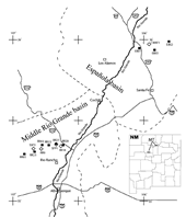 
The Santa Fe region is growing rapidly. The Santa Fe Group aquifer in the Española Basin is the main source of municipal water for the region, and water shortfalls could have serious consequences. Future growth and land management in the region depend on accurate assessment and protection of the region’s ground-water resources. An important issue in managing the ground-water resources is a better understanding of the hydrogeology of the Tertiary Santa Fe Group. The Santa Fe Group includes the sedimentary deposits that fill the Rio Grande rift and contain the principal ground-water aquifers. The U.S. Geological Survey (USGS) is conducting a series of multidisciplinary studies of the Española Basin in northern New Mexico. Detailed geologic mapping, high-resolution airborne magnetic surveys, electromagnetic surveys, and hydrologic, lithologic, and hydro-geochemical data are being...>>MORE |
Version 1.0 Posted May 2006
|
Part or all of this report is presented in Portable Document Format (PDF); the latest version of Adobe Acrobat Reader or similar software is required to view it. Download the latest version of Acrobat Reader, free of charge or go to access.adobe.com for free tools that allow visually impaired users to read PDF files.
