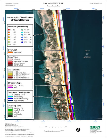
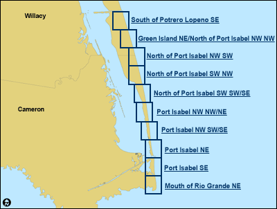
Link to USGS home page Link to USGS home page
Coastal and Marine Geology Program
Coastal & Marine Geology Program > Coastal Classification Mapping Project > Open File Report 2006-1133

Coastal Classification Atlas

South Texas Coastal Classification Maps - Mansfield Channel to the Rio Grande

USGS Open File Report 2006-1133

Robert A. Morton, Russell L. Peterson

Report Home Maps Overview Mapping Methods Coastal Classifications Geologic Setting Coastal Processes Coastal Vulnerability Classification Summary References
Introduction || City: Mouth of Rio Grande | Port Isabel | North of Port Isabel | Green Island/North of Port Isabel | South of Potrero Lopeno

Coastal Classification Map Introduction

Each map shows an area with the coastal classifications marked as color bars along the shoreline. Below is an example map of Port Isabel NW SW/SE. To find out more about how the classification system works, see the Coastal Classifications section. At the bottom of the page is a clickable index map that will take you to the other maps.

Example Coastal Classification map for Port Isabel Northwest Southwest/Southeast.
Example Coastal Classification map for Port Isabel NW SW/SE.

Index map.
Clickable Index Map. Use the index map above to navigate to the different coastal areas.

Coastal & Marine Geology Program > Coastal Classification Mapping Project > Open File Report 2006-1133


Mouth of Rio Grande NortheastPort Isabel SoutheastPort Isabel NortheastPort Isabel Northwest Southwest/SoutheastPort Isabel Northwest Northwest/NortheastNorth of Port Isabel Southwest Southwest/SoutheastNorth of Port Isabel Southwest NorthwestNorth of Port Isabel Northwest SouthwestGreen Island Northeast/North of Port Isabel Northwest NorthwestSouth of Potrero Lopeno Southeast
FirstGov button  Take Pride in America button