Open-File Report 2006–1138
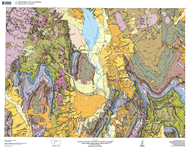 
The geologic map of the Townsend quadrangle, scale 1:100,000, was made as part of the Montana Investigations Project to provide new information on the stratigraphy, structure, and geologic history of this geologically complex area in west-central Montana. The quadrangle encompasses about 4,200 square km (1,640 square mi). PurposeThe geologic map of the Townsend quadrangle, Montana, provides a summary of new and selected existing geologic information for public use and use by Federal, State, and local governmental agencies for land-use planning, including assessment of natural resources and natural hazards and recreational potential, and for land-use management. The geologic map is an element in the cooperative program between the State of Montana and the U.S. Geological Survey to produce 1:100,000-scale geologic map coverage for the entire State. |
Version 1.0 Posted May 2006
|
Part or all of this report is presented in Portable Document Format (PDF); the latest version of Adobe Acrobat Reader or similar software is required to view it. Download the latest version of Acrobat Reader, free of charge or go to access.adobe.com for free tools that allow visually impaired users to read PDF files.
