CASANC - Boundaries for the Monterey Bay, Cordell Bank, and Gulf of the Farallones National Marine Sanctuaries

CASANC - Boundaries for the Monterey Bay, Cordell Bank, and Gulf of the Farallones National Marine Sanctuaries

Metadata also available as

Frequently-anticipated questions:


What does this data set describe?

Title:
CASANC - Boundaries for the Monterey Bay, Cordell Bank, and Gulf of the Farallones National Marine Sanctuaries
Abstract:

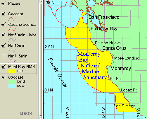
CASANC is a polygon coverage showing the offshore boundaries of the national marine sanctuaries (NMS) off central California: Monterey Bay NMS, Cordell Bank NMS, and Gulf of the Farallones NMS and the adjacent coastline.

This is one of a collection of digital files of a geographic information system of spatially referenced data related to the USGS Coastal and Marine Geology Program "Monterey Bay National Marine Sanctuary Project" <http://walrus.wr.usgs.gov/mbms>. The data were collected and analyzed between 1994 and 2000.

  1. How should this data set be cited?

    Hamer, Michael R. , and Wong, Florence L. , 2001, CASANC - Boundaries for the Monterey Bay, Cordell Bank, and Gulf of the Farallones National Marine Sanctuaries:.

    Online Links:

    This is part of the following larger work.

    Wong, F.L., and Eittreim, S.E., 2001, Continental Shelf GIS for the Monterey Bay National Marine Sanctuary: U.S. Geological Survey Open-File Report 01-179, U.S. Geological Survey, Menlo Park, CA.

    Online Links:

  2. What geographic area does the data set cover?

    West_Bounding_Coordinate: -123.64961319
    East_Bounding_Coordinate: -121.03339135
    North_Bounding_Coordinate: 38.33459951
    South_Bounding_Coordinate: 35.54617104

  3. What does it look like?

    <http://geopubs.wr.usgs.gov/open-file/of01-179/images/basemaps.gif> (GIF)
    location map of casanc

  4. Does the data set describe conditions during a particular time period?

    Calendar_Date: 1998
    Currentness_Reference: Ground Condition

  5. What is the general form of this data set?

    Geospatial_Data_Presentation_Form: map

  6. How does the data set represent geographic features?

    1. How are geographic features stored in the data set?

      This is a Vector data set. It contains the following vector data types (SDTS terminology):

      • Point (4287)
      • String (4426)
      • GT-polygon composed of chains (4288)

    2. What coordinate system is used to represent geographic features?

      Grid_Coordinate_System_Name: Universal Transverse Mercator
      Universal_Transverse_Mercator:
      UTM_Zone_Number: 10
      Transverse_Mercator:
      Scale_Factor_at_Central_Meridian: 0.9996
      Longitude_of_Central_Meridian: -123.00000
      Latitude_of_Projection_Origin: 0.00000
      False_Easting: 500000.00
      False_Northing: 0.00

      Planar coordinates are encoded using coordinate pair
      Abscissae (x-coordinates) are specified to the nearest 103.9406942649
      Ordinates (y-coordinates) are specified to the nearest 103.9406942649
      Planar coordinates are specified in Meters

      The horizontal datum used is North American Datum of 1983.
      The ellipsoid used is GRS1980.
      The semi-major axis of the ellipsoid used is 6378137.0.
      The flattening of the ellipsoid used is 1/298.257.

  7. How does the data set describe geographic features?

    Entity_and_Attribute_Overview:

     The polygons in the coverage CASANC are identified
     in the attributes SANC_ID and SANC_NAME:
    
     SANC_ID is a 2-letter code for sanctuary polygons
          cb = Cordell Bank
          fi = Gulf of the Farallones
          mb = Monterey Bay
    
     SANC_NAME is the full sanctuary name
          Cordell Bank National Marine Sanctuary
          Gulf of the Farallones National Marine Sanctuary
          Monterey Bay National Marine Sanctuary
    
     The lines in the coverage CASANC are identified in
     the attribute LTYPE:
    
     LTYPE =  'coast' for coastline arcs; 'sanc' for sanctuary boundary
    
    Entity_and_Attribute_Detail_Citation: none


Who produced the data set?

  1. Who are the originators of the data set? (may include formal authors, digital compilers, and editors)

  2. Who also contributed to the data set?

  3. To whom should users address questions about the data?

    Florence L. Wong
    United States Geological Survey (USGS)
    Geologist, GIS Coordinator
    USGS, MailStop 999, 345 Middlefield Road
    Menlo Park, CA 94025-3561
    USA

    (650) 329-5327 (voice)
    (650) 329-5190 (FAX)
    fwong@usgs.gov


Why was the data set created?

These data are intended for science researchers, students, policy makers, and the general public. The data can be used with geographic information systems (GIS) software to display geologic and oceanographic information about the shallower areas of the Monterey Bay National Marine Sanctuary.


How was the data set created?

  1. From what previous works were the data drawn?

    NOAA (1992) (source 1 of 2)
    NOS, NOAA, 1992, Monterey Bay National Marine Sanctuary Bathymetry.

    Type_of_Source_Media: paper
    Source_Contribution: list of coordinates

    Hall (1998) (source 2 of 2)
    Hall, R.K., 1998 or earlier, Boundaries of Gulf of the Farallones NMS and Cordell Bank NMS.

    Type_of_Source_Media: electronic
    Source_Contribution: boundary lines

  2. How were the data generated, processed, and modified?

    Date: 1998 (process 1 of 2)
    Michael Hamer generated Monterey Bay NMS boundary from coordinates published in NOAA (1992). Appended data for Gulf of the Farallones NMS and Cordell Bank NMS. Appended CACOAST and built polygons.

    Date: 28-Mar-2001 (process 2 of 2)
    First draft of metadata created by F.L. Wong using a modified version of FGDCMETA.AML on ARC/INFO data set CASANC

  3. What similar or related data should the user be aware of?


How reliable are the data; what problems remain in the data set?

  1. How well have the observations been checked?

  2. How accurate are the geographic locations?

  3. How accurate are the heights or depths?

  4. Where are the gaps in the data? What is missing?

    Complete

  5. How consistent are the relationships among the observations, including topology?

    Polygon and chain-node topology present.


How can someone get a copy of the data set?

Are there legal restrictions on access or use of the data?

Access_Constraints: None
Use_Constraints:
Please recognize the U.S. Geological Survey (USGS) as the source of this information.

Although these data have been used by the U.S. Geological Survey, U.S. Department of the Interior, no warranty expressed or implied is made by the U.S. Geological Survey as to the accuracy of the data.

The act of distribution shall not constitute any such warranty, and no responsibility is assumed by the U.S. Geological Survey in the use of this data, software, or related materials.

This information is not intended for navigational purposes.

Any use of trade, firm, or product names is for descriptive purposes only and does not imply endorsement by the U.S. Government.

  1. Who distributes the data set? (Distributor 1 of 1)

    United States Geological Survey (USGS)
    c/o Florence L. Wong
    Geologist, GIS Coordinator
    USGS, MailStop 999, 345 Middlefield Road
    Menlo Park, CA 94025-3561
    USA

    (650) 329-5327 (voice)
    (650) 329-5190 (FAX)
    fwong@usgs.gov

  2. What's the catalog number I need to order this data set?

    USGS Open-File Report 01-179

  3. What legal disclaimers am I supposed to read?

    Please recognize the U.S. Geological Survey (USGS) as the source of this information.

    Although these data have been used by the U.S. Geological Survey, U.S. Department of the Interior, no warranty expressed or implied is made by the U.S. Geological Survey as to the accuracy of the data.

    Any use of trade, product, or firm names is for descriptive purposes only and does not imply endorsement by the U.S. Government.

    The act of distribution shall not constitute any such warranty, and no responsibility is assumed by the U.S. Geological Survey in the use of this data, software, or related materials.

  4. How can I download or order the data?


Who wrote the metadata?

Dates:
Last modified: 29-Mar-2001
Last Reviewed: May-2001
Metadata author:
United States Geological Survey (USGS)
c/o Florence L. Wong
Geologist, GIS Coordinator
USGS, MailStop 999, 345 Middlefield Road
Menlo Park, CA 94025-3561
USA

(650) 329-5327 (voice)
(650) 329-5190 (FAX)
fwong@usgs.gov

Metadata standard:
Content Standard for Digital Geospatial Metadata ("CSDGM version 2") (FGDC-STD-001-1998)


Generated by mp version 2.8.6 on Thu Dec 08 11:22:48 2005