|
Metadata also available as - [ Outline] - [ Parseable text] - [ XML]
Frequently-anticipated questions:
- Title:
-
Digital single-channel seismic-reflection data from Western Santa Monica Basin
- Abstract:
-
During a collaborative project in 1992, a Canadian Geological Survey cruise obtained about
850 line-km of high-quality boomer and sleeve-gun reflection profiles across Hueneme, Mugu
and Dume submarine fans, Santa Monica Basin, off southern California. The goals of this work
were to better understand the processes that lead to the formation of sandy submarine fans and
the role of sea-level changes in controlling fan development.
This report includes a trackline map of the area surveyed, as well as images of the sleeve-gun
profiles and the opportunity to download both images and digital data files (SEG-Y) of all the
profiles.
- Supplemental_Information:
-
Additional information for this USGS Coastal and Marine Geology field activity is available
online at <http://walrus.wr.usgs.gov/infobank/p/p192sc/html/p-1-92-sc.meta.html>.
- How should this data set be cited?
Normark, William R. , Piper, David J.W. , Sliter, Ray W. , Triezenberg, Peter, and Gutmacher, Christina E. , 2006, Digital single-channel seismic-reflection data from Western Santa Monica Basin: USGS Open-File Report USGS OFR 2006-1180, United States Geological Survey, Menlo Park, California.
Online Links:
- What geographic area does the data set cover?
- West_Bounding_Coordinate: -119.50000
- East_Bounding_Coordinate: -118.50000
- North_Bounding_Coordinate: +34.16667
- South_Bounding_Coordinate: +33.50000
- What does it look like?
- <http://pubs.usgs.gov/of/2006/1180/map/parizeau.svg> (SVG)
-
Index map of tracklines covered in this report.
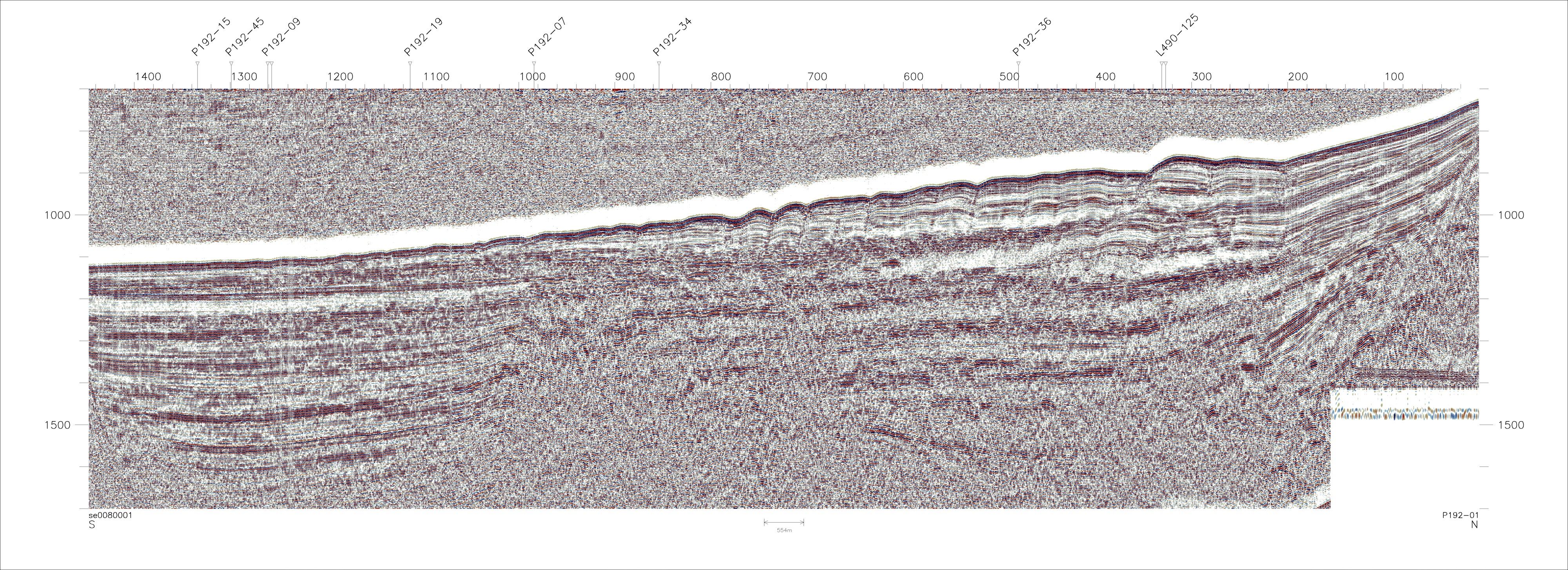
- <http://pubs.usgs.gov/of/2006/1180/jpg/se100/p1se0001.jpg> (JPEG)
-
Example of sleeve-gun seismic data accessible via this report.
- Does the data set describe conditions during a particular time period?
- Beginning_Date: 30-Jan-1992
- Ending_Date: 04-Feb-1992
- Currentness_Reference: Time span of data collection (GSC).
- What is the general form of this data set?
- Geospatial_Data_Presentation_Form:
-
Text report containing graphical map images and geophysical data images (no spatial
referencing).
- How does the data set represent geographic features?
- How are geographic features stored in the data set?
- What coordinate system is used to represent geographic features?
- Grid_Coordinate_System_Name: Universal Transverse Mercator
- Universal_Transverse_Mercator:
-
- UTM_Zone_Number: 11
- Transverse_Mercator:
-
- Scale_Factor_at_Central_Meridian: 0.9996
- Longitude_of_Central_Meridian: -117.0
- Latitude_of_Projection_Origin: 0.0
- False_Easting: 500000
- False_Northing: 0
Planar coordinates are encoded using coordinate pair
Abscissae (x-coordinates) are specified to the nearest 25
Ordinates (y-coordinates) are specified to the nearest 25
Planar coordinates are specified in Meters
The horizontal datum used is North American Datum of 1983.
The ellipsoid used is GRS1980.
The semi-major axis of the ellipsoid used is 6378206.4.
The flattening of the ellipsoid used is 1/294.98.
- How does the data set describe geographic features?
- Entity_and_Attribute_Overview:
-
Locations of data profiles are shown as a map image at an unspecified projection
and scale. This Scalable Vector Graphics (SVG) map allows mouse over trackline
details and links to profile displays. The images of the reflection profiles are
rendered in TIFF and JPEG image formats. Links are provided to the SEG-Y digital
data for each line.
- Entity_and_Attribute_Detail_Citation: none
- Who are the originators of the data set? (may include formal authors, digital compilers, and editors)
- William R. Normark
- David J.W. Piper
- Ray W. Sliter
- Peter Triezenberg
- Christina E. Gutmacher
- Who also contributed to the data set?
Peter Triezenberg produced the interactive web pages for this report.
- To whom should users address questions about the data?
Ray W. Sliter
United States Geological Survey (USGS)
Geophysicist
USGS, Mail Stop 999, 345 Middlefield Road
Menlo Park, CA 94025-3561
USA
(650) 329-5194 (voice)
rsliter@usgs.gov
These sleeve-gun data were collected as part of a project investigating deep-sea fans. They have
subsequently become useful to a current project working to identify the active fault systems in the
southern California coastal zone, including the continental shelf and adjacent deep basins,
that pose the greatest potential seismic hazards for the most populated urban corridor along
the U.S. Pacific margin. See <http://walrus.wr.usgs.gov/cabrillo/tierra/index.html> for more
information. This report is prepared to make these data available to science researchers,
students, and other interested parties.
- From what previous works were the data drawn?
- How were the data generated, processed, and modified?
- Date: 2004 (process 1 of 4)
-
Refer to report sections "Data acquisition method" and "Data processing" for details
of geophysical data acquisition and processing sequence used for data in this report.
Ray W. Sliter
- Date: 2005 (process 2 of 4)
-
Plotted shot point map of cruises using GMT <http://gmt.soest.hawaii.edu/> to create sub-maps.
Converted plots to TIFF and JPEG files to provide format options for downloading data.
Ray W. Sliter
- Date: 2006 (process 3 of 4)
-
Used GEODAS (GEOphysical DAta System) to create a custom bathymetric and topographic grid
for the southern California region covered by the cruise index map.
The website is: <http://www.ngdc.noaa.gov/mgg/geodas/geodas.html>.
The parameters used are as follows:
Grid database: US Coastal Relief Model Grids
Lat/Lon Area Bounds: 34.16667 N to 33.50000 N, 119.50000 W to 118.50000 W
Grid Cell Size: 3 seconds
Grid Cell Value Parameters: 4-byte integers, 10ths of meters
Grid Format: xyz (lon, lat, depth) format, no header, space-delimited, exclude empty cells.
Peter Triezenberg
- Date: 2006 (process 4 of 4)
-
Plotted tracklines of seismic reflection profiles using GMT <http://gmt.soest.hawaii.edu/>
to create maps. Created Scalable Vector Graphics (SVG) map to allow mouse-over of trackline
details and links to profile displays.
Peter Triezenberg
- What similar or related data should the user be aware of?
- How well have the observations been checked?
Data have not been independently verified.
- How accurate are the geographic locations?
Shot point numbers in the data files correspond to those in the navigation files. The
horizontal positional accuracy of the seismic data thus linked to ship's position is
estimated to be within 30 meters. See Appendix for details of navigational system used.
- How accurate are the heights or depths?
Depths shown in the seismic data files are in milliseconds (round trip travel time) and
are referenced to sea level.
- Where are the gaps in the data? What is missing?
Reference the full report for a description of data coverage. All sleeve-gun data collected
on the referenced cruise have been included in this report. Some seismic profiles have gaps
in them due to system crashes or hardware maintenance.
- How consistent are the relationships among the observations, including topology?
Undetermined.
Are there legal restrictions on access or use of the data?
- Access_Constraints: None
- Use_Constraints:
-
These data are not intended for navigational purposes.
Please recognize the U.S. Geological Survey (USGS) as the source of this information.
- Who distributes the data set? (Distributor 1 of 1)
Ray W. Sliter
United States Geological Survey (USGS)
USGS, Mail Stop 999, 345 Middlefield Road
Menlo Park, CA 94025-3561
USA
(650) 329-5194 (voice)
rsliter@usgs.gov
- What's the catalog number I need to order this data set?
United States Geological Survey Open-File Report 2006-1180 This report is distributed on-line only. Access it at <http://pubs.usgs.gov/of/2006/1180/>.
- What legal disclaimers am I supposed to read?
Please recognize the U.S. Geological Survey (USGS) as the source of this information.
Although these data have been used by the U.S. Geological
Survey, U.S. Department of the Interior, these data and
information are provided with the understanding that they
are not guaranteed to be usable, timely, accurate, or
complete. Users are cautioned to consider carefully
the provisional nature of these data and information
before using them for decisions that concern personal or
public safety or the conduct of business that involves
substantial monetary or operational consequences.
Conclusions drawn from, or actions undertaken on the basis
of, such data and information are the sole responsibility
of the user.
Neither the U.S. Government nor any agency thereof, nor any
of their employees, make any warranty, express or implied,
nor assume any legal liability or responsibility for the
accuracy, completeness, or usefulness of any data, software,
information, apparatus, product, or process disclosed, nor
represent that its use would not infringe on privately owned
rights.
Trade, firm, or product names and other references to
commercial products and services are provided for information
only and do not constitute endorsement or warranty, express
or implied, by the USGS, USDOI, or U.S. Government, as to their
suitability, content, usefulness, functioning, completeness,
or accuracy.
- How can I download or order the data?
- Dates:
- Last modified: 26-Jun-2006
- Metadata author:
-
Ray W. Sliter
United States Geological Survey (USGS)
Geophysicist
USGS, Mail Stop 999, 345 Middlefield Road
Menlo Park, CA 94025-3561
USA
(650) 329-5194 (voice)
rsliter@usgs.gov
- Metadata standard:
- Content Standard for Digital Geospatial Metadata ("CSDGM version 2") (FGDC-STD-001-1998)
Generated by mp version 2.8.11 on Wed Jun 28 13:19:09 2006
|
|
