Data Catalog
The data supplied on this CD-ROM are made available with geographic coordinates to allow the data to be incorporated into a Geographic Information System (GIS). The data layers along with additional base map layers have been compiled into an Environmental Systems Research Institute (ESRI) project file (Sed_Archive.apr), which is located at the top-level directory of this publication. The project file serves to provide an example of how the data can be displayed in a GIS. A variety of basemap layers that can be used to accompany these data can be found on the Coastal and Marine Geology Program's Internet Map Server. Several have been included below and are used in the project file.
The project Sed_Archive.apr is setup to "hotlink" to online descriptions of the samples in the WHSC's archives. The EvokeBrowser extension provided by Flat World Technologies must be loaded for this to work. This extension will be loaded by default within the project file.
For those who do not have the ESRI software or a compatible GIS data browser available on their computer, a free viewer, ArcExplorerTM, is available from ESRI. The ArcExplorerTM software is available for both Microsoft Windows and Mac OSX operating systems.
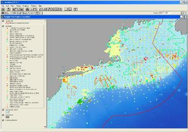
Example of geographic display of the Sediment Archive database, with classification of sample points based on the type of collection device used. Click here for larger image. |
Clicking on the layer name under the column header "Data Layer Name & Description" in the table below will open a new window with a graphical representation of that layer. Federal Geographic Data Committee (FGDC) metadata are included with data layers in three formats in the table below: (HTML, FAQ, and text).
A downloadable zip archive file containing the elements that comprise the ESRI shapefile for each data layer is also provided. Each zip file includes:
- ESRI shapefile for each layer (with associated files)
- Comma-delimited text version of the data file
- All three standard versions of the metadata
- Browse graphic of the data layer
The zip files were created using WinZip v. 8.1. Users may obtain a free copy of the software from WinZip. In addition to the sed_archive ESRI shapefile, the archive database is available in Microsoft Excel workbook, and an ASCII text format as alternate ways to view and examine the data set. The first record of the ASCII file contains the name of the data fields for that file.
Data Files
The data and basemaps provided below may be entered into a GIS to gain a visual perspective of the distribution of collection sites, and links to images and associated data, information and descriptions, where available.
The Database
| Data Layer Name & Description |
Metadata |
Files |
File Size |
| sed_archive - The WHSC Sediment Archive's sample database, including collection metadata, storage information and links to relevant materials |
HTML
FAQ
txt |
sed_archive.zip |
3.12 MB |
Basemap Layers
|

