Surficial sediment character of the Louisiana offshore continental shelf region: A GIS Compilation
|
|
Browse MapsOverview
For this section of the publication, we have chosen to focus on Extracted and Parsed data within the usSEABED collection. Extracted data: those data from strictly performed, lab-based, numeric analyses. The _EXT file is based on rigorous lab-determined values and forms the most reliable data sets. Numeric data obtained from verbal logs from core descriptions, shipboard notes, and (or) photographic descriptions are held in the parsed data set (_PRS). The input data are maintained using the terms employed by the original researchers and are coded using phonetically sensible terms for easier processing by dbSEABED. For expanded definition of these data sets, please consult the section of this publication. |
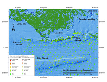
The map below highlights mean grain size character of the Isles Dernieres shoreline and the inner shelf region, including Ship Shoal, a major marine sand body. Ship Shoal, a drowned barrier island, is one of several marine sand bodies being considered as a source of sand for barrier restoration. Within the usSEABED data set, mean grain size represents the calculated average phi size from standard lab-based sample methods (extracted data) and word-based (parsed data) observational data.
. |
|
 |
|||
Images are best viewed at full size. The images included in this publication are designed to be printed on 8.5" x 11" sheets of paper, and therefore are best viewed on screen at full resolution.
 |
Map of the primary sedimentary provinces offshore Louisiana based on the sea floor morphology, underlying framework geology and sedimentary features comprising the sea floor. The shelf is mostly featureless except for the four major marine sand bodies shown. The Mississippi Valley transects the outer shelf and slope and likely serves as a conduit for moving sediments to deeper parts of the Basin. |
|
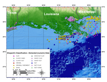 |
Map of surficial sediment distribution based on Shepard' 1954 sediment classification showing extracted (numeric) data only. NOTE: For many of the samples identified as containing gravel, the gravel consists of shells and shell fragments. Users are encouraged to thoroughly investigate and understand all data on a sample before accepting these designations. | |
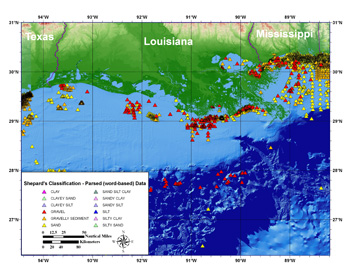 |
Map of surficial sediment distribution based on Shepard' 1954 sediment classification showing parsed (word-based) data only. Inclusion of parsed data greatly increases the amount of available data and overall geographical coverage. NOTE: For many of the samples identified as containing gravel, the gravel consists of shells and shell fragments. Users are encouraged to thoroughly investigate and understand all data on a sample before accepting these designations. | |
 |
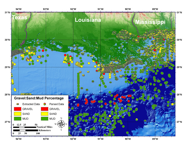
Map of gravel-sand-mud percentages of the surficial sediment. Map view symbols represent the parsed data, while oblique view symbols represent the extracted data. This type of a display offers more insight into the overall sediment composition than the simplified view of mean grain size. This is often most useful for fish-habitat studies, where sea floor composition is more important than generalized or averaged sediment information. | |
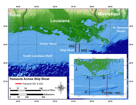 |
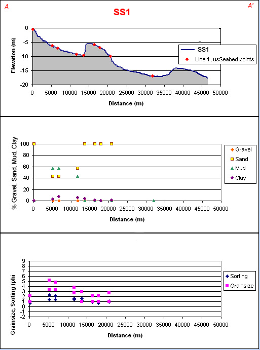
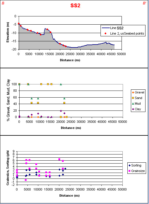
Example of two shore-normal transects from the Isles Dernieres to Ship Shoal, where usSEABED data may be displayed superimposed on high resolution NOAA bathymetry. Click the image for a larger view, or click the line to bring up the transect details. | |
| Screen Size | Full Size | pdf Version | Transect 1 (html) (jpeg) (pdf) | Transect 2 (html) (jpeg) (pdf) | |
||
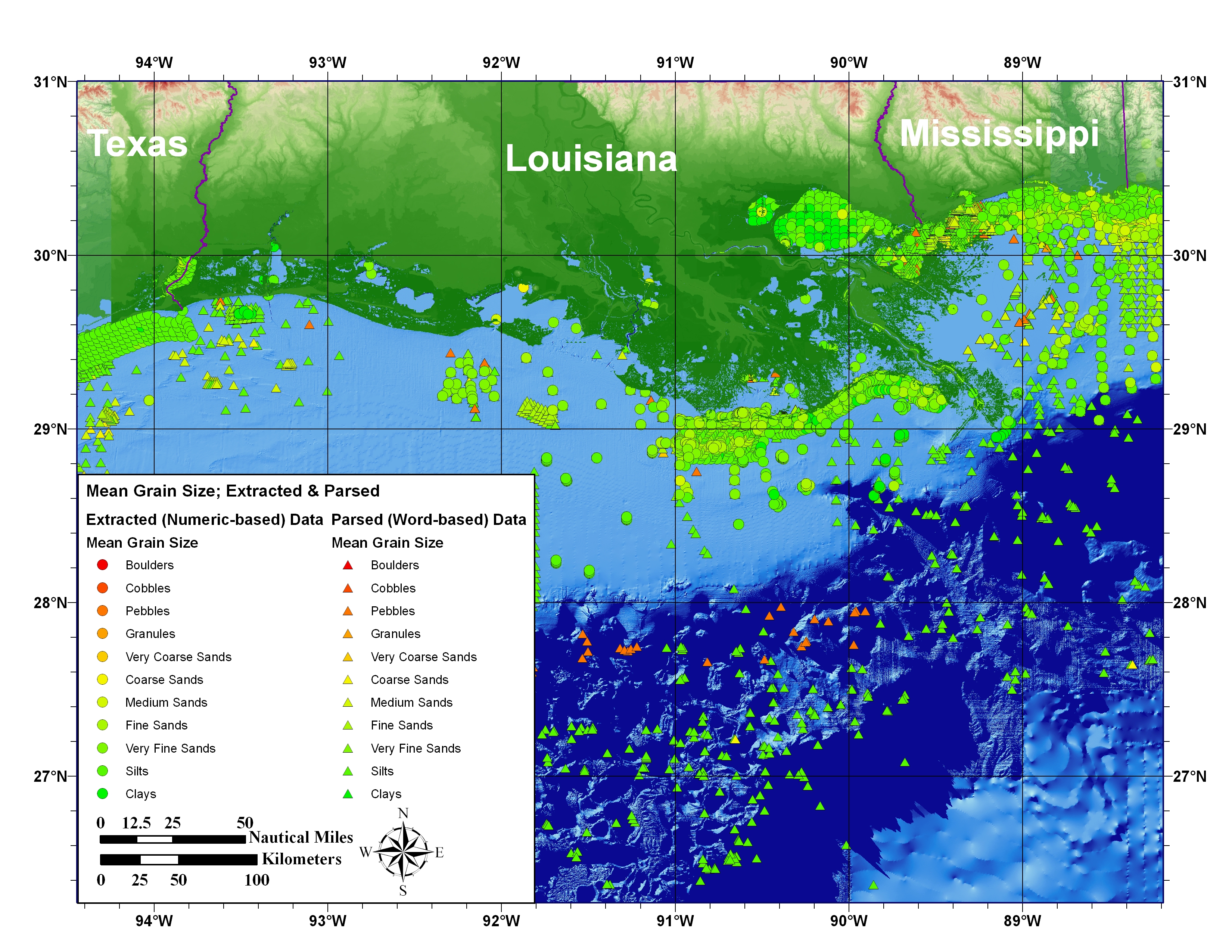 |
Map of mean grain size of surficial sediment based on both extracted and parsed data in usSEABED. | |
 |
Map of sediment sorting of extracted and parsed data (over 29,000 samples for the Louisiana region). NOTE: Values of moment sorting are simply passed through to output. Graphical measures of sorting such as those of Inman and Folk are not generally compatible with moment measures and at present do not contribute to outputs. For additional information, visit the usSEABED Web Page. | |
![]() To view files in PDF format, download free copy of Adobe Reader.
To view files in PDF format, download free copy of Adobe Reader.
Main Menus
OFR 2006-1195 Home | Introduction | Nomenclature | Coastal Change | Data Dictionary | Data Catalog | Browse Maps | References | Related Web Sites | For Educators | Acknowledgments | Contacts | Disclaimer| README
Sub-Menus
Browse Maps | Sediment Character Examples

![]() U.S. Department of the Interior |
U.S. Geological Survey
U.S. Department of the Interior |
U.S. Geological Survey
URL: http://pubsdata.usgs.gov/pubs/of/2006/1195/htmldocs/browse_maps.htm
Page Contact Information: Publishing Services
Page Last Modified: Saturday, 12-Jan-2013 22:32:25 EST
