 |
|
|
||||
| Grand Canyon Monitoring and Research Center |
|
|
|
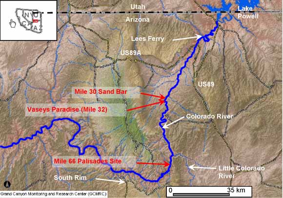
Introduction In November 2004, an experimental high flow release of water from Glen Canyon Dam into the Colorado River through Grand Canyon National Park in Arizona was conducted. The goal of the experiment was to evaluate the use of high flow events as a management tool for the preservation and restoration of natural resources in the Colorado River below Glen Canyon Dam. The U.S. Geological Survey (USGS), Grand Canyon Monitoring and Research Center (GCMRC) located in Flagstaff, Arizona performed oversight of all aspects of scientific data collection including suspended sediment transport studies, biological population variations, effects on archaeological resources, and morphological studies of river sand bars. As part of the experimental high flow studies, the USGS Coastal and Marine Geology (CMG) team was invited to participate to test the effectiveness of utilizing terrestrial LIDAR technology for gathering morphological data on sand bars, biological habitats, and archaeological sites. The CMG is equipped with a terrestrial LIDAR unit and has used the technique in a variety of terrains to gather high-resolution morphological data. A three-member team from CMG participated in the experiment, joining a GCMRC team on a river trip from November 18 to November 21, 2004. This report begins with a brief description of the LIDAR technique and then outlines the data collected, processing required, and results for three study areas located within the Grand Canyon. Specifically, studies were performed at the Mile 30 Sand Bar, at Vaseys Paradise (Mile 32), and at the Mile 66 Palisades Archaeological Site. Conclusions and recommendations for utilizing terrestrial LIDAR for future studies at each of these sites are also included. |
Download Open-File Report 2006-1198 as a 32-page PDF file (7.9 MB)
For questions about the content of this report, contact Brian Collins
Download a current version of Adobe Reader for free
| Help
| PDF help
| Western reports main page | Open-File Reports for 2006 |
| Privacy
Statement | Disclaimer
| Accessibility |
| Geologic
Division | Coastal and Marine Geology Program
|