Geophysical Unit of Menlo Park, Calif.
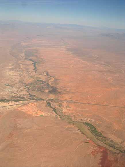
Oblique aerial view, looking north, of Muddy River (bottom third of image) and Meadow Valley Wash (top two-thirds). Interstate 15 crosses the image in its bottom half.
Gravity and seismic data from Tule Desert, Meadow Valley Wash, and California Wash, Nevada, provide insight into the subsurface geometry of these three basins that lie adjacent to rapidly developing areas of Clark County, Nevada. Each of the basins is the product of Tertiary extension accommodated with the general form of north-south oriented, asymmetrically-faulted half-grabens. Geophysical inversion of gravity observations indicates that Tule Desert and Meadow Valley Wash basins are segmented into subbasins by shallow, buried basement highs. In this study, “basement” refers to pre-Cenozoic bedrock units that underlie basins filled with Cenozoic sedimentary and volcanic units. In Tule Desert, a small, buried basement high inferred from gravity data appears to be a horst whose placement is consistent with seismic reflection and magnetotelluric observations. Meadow Valley Wash consists of three subbasins separated by basement highs at structural zones that accommodated different styles of extension of the adjacent subbasins, an interpretation consistent with geologic mapping of fault traces oblique to the predominant north-south fault orientation of Tertiary extension in this area. California Wash is a single structural basin. The three seismic reflection lines analyzed in this study image the sedimentary basin fill, and they allow identification of faults that offset basin deposits and underlying basement. The degree of faulting and folding of the basin-fill deposits increases with depth. Pre-Cenozoic units are observed in some of the seismic reflection lines, but their reflections are generally of poor quality or are absent. Factors that degrade seismic reflector quality in this area are rough land topography due to erosion, deformed sedimentary units at the land surface, rock layers that dip out of the plane of the seismic profile, and the presence of volcanic units that obscure underlying reflectors. Geophysical methods illustrate that basin geometry is more complicated than would be inferred from extrapolation of surface topography and geology, and these methods aid in defining a three-dimensional framework to understand groundwater storage and flow in southern Nevada.
Download this report as a 44-page PDF file (of2006-1396.pdf; 10.7 MB).
Open the Readme file for the gravity data (of2006-1396_readme.txt; 56 KB).
Download the gravity data as a comma-separated-value (CSV) ASCII file (of2006-1396_gravity.csv; 248 KB). This file contains principal facts of 3435 gravity stations within the study area.
For questions about the content of this report, contact Dan Scheirer
Download a copy of the latest version of Adobe Reader for free.
|
Help |
PDF help |
Publications main page |
| Western Open-File Reports for 2006 |
| Geologic Division |
Geophysical Unit of Menlo Park, Calif. (GUMP)
|

![]() U.S. Department of the Interior | U.S. Geological Survey
U.S. Department of the Interior | U.S. Geological Survey
URL: http://pubs.usgs.gov/of/2006/1396/
Page Contact Information: Michael Diggles
Page Last Modified: January 30, 2007